A dynamic storm cycle is making its mark across multiple regions this week and weekend, bringing a mix of rain, heavy snow, and fluctuating temperatures. While some areas will see wet and heavy snow initially, colder air moving in will improve conditions, setting us up for some deep days. From the Wasatch to the San Juans and Canada), there's a lot going on this week as the season draws near.
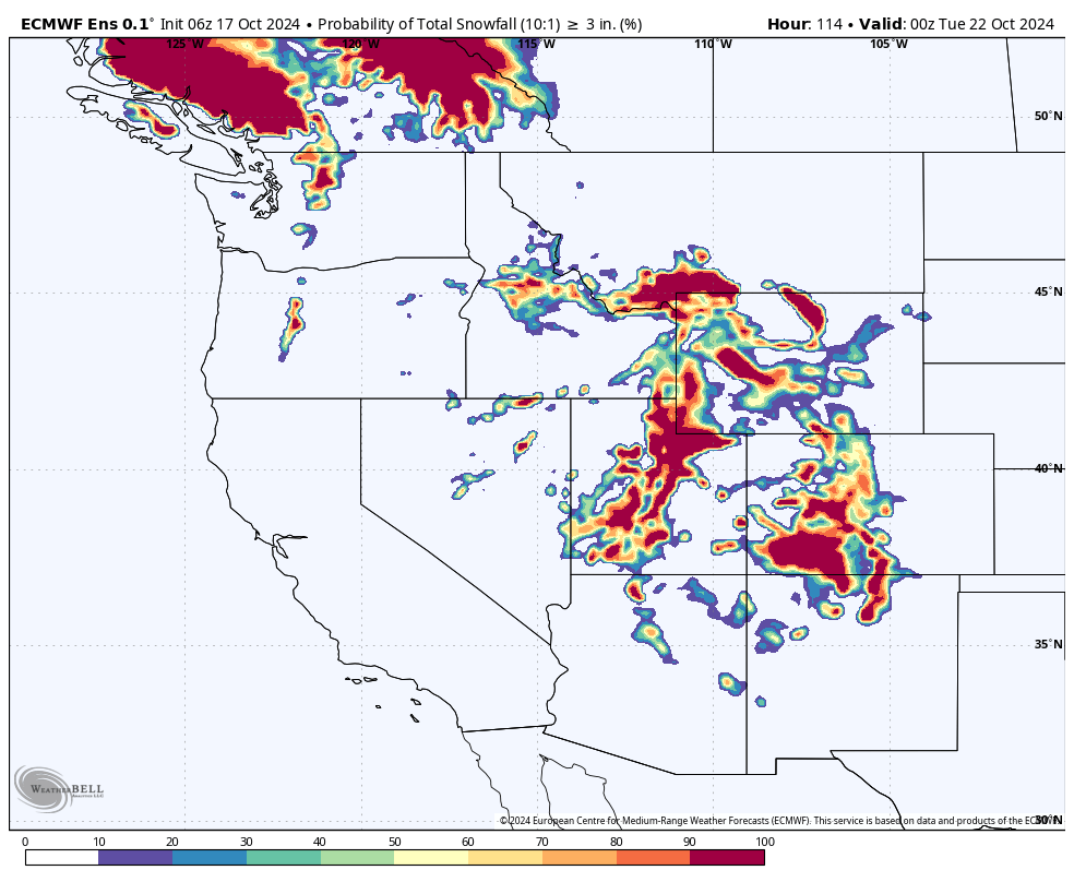
Below: Low pressure races down from Canada impacting BC and Alberta initially (5-10 inches), focusing on Montana (Big Sky should do well)Thursday-Friday, Utah late Thursday to Friday, and Colorado by Friday-Sunday. The low gets cutoff and stalls over Arizona this weekend pushing moisture north into the San Juan range this weekend.

Utah

Rain transitioned to snow this morning at many Utah resorts, and we can expect temperatures to steadily drop throughout the storm. By Friday morning, temperatures will bottom out in the low 20s, setting the stage for some great snow conditions. During this storm, snowfall will initially be dense, with a snow-liquid ratio (SLR) between 6:1 and 8:1 on Thursday, but it will become fluffier overnight, reaching around 16:1 by Friday morning.
Snow levels will be between 9,000-10,000 feet for much of the storm's initial precipitation. By early Friday morning, they will drop to as low as 5,500 feet. Winds will gust up to 30-35 mph from the southwest on Thursday, shifting to westerly by Thursday night, and calming to around 20 mph as the wind direction changes to come from the north by Friday morning.
Snowfall rates will initially peak around 9 a.m. on Thursday at about a third of an inch per hour before decreasing throughout the day. A second wave of snowfall will arrive Thursday evening, increasing snowfall rates to 0.5-1 inch per hour overnight.
Storm Totals at Mid-Mountain:
-
Cottonwood Canyon Resorts: 8-14"
-
Park City: 4-8"
-
Powder Mountain: 2-4"
-
Beaver Mountain: 2-4"
Colorado

The first wave of precipitation will arrive in Colorado on Thursday morning, primarily hitting the southwest and west-central mountains. There won't be much of a break between the first and second waves, with the second wave intensifying by midday Friday, dumping snow in the western mountains to start and moving east over the following hours. The storm will linger into Monday morning, with a significant surge of moisture and snowfall from the south and southeast arriving on Sunday afternoon.
Temperatures will decrease steadily throughout the storm, reaching their lowest point on Monday morning. Snow levels will start around 11,000 feet, dropping to 8,000 feet by the storm's end. Big diurnal swings could lead to warmer temperatures during the day, causing rain or mixed precipitation at mid-to-lower resort elevations.
Winds will remain fairly light for most of the storm.
Storm Totals at Mid-Mountain: Southern Colorado will be hit hardest due to the precipitation placement and favorable southwest winds. Snow moves further north by Sunday.
-
Steamboat: 3-5" (mostly rain during the storm)
-
Winter Park: 5-8"
-
Summit County Resorts: 6-10"
-
I-70 Resorts: 3-6"
-
Aspen/Snowmass: 4-8"
-
Telluride: 12-18"
-
Silverton: 24-32"
-
Wolf Creek: 24-32"
Much of Colorado will focus on the southern Mountains initially with a band moving into the I-70 corridor on Sunday.
Below: Sunday surge of moisture from the south will likely impact the I-70 corridor.

Pacific Northwest and Canada
The Pacific Northwest will see an active weekend, with precipitation starting midday Friday and continuing through Monday morning. Models are still uncertain about the exact totals, but we can expect a fairly warm storm system with relatively small snow totals at resorts.
Canada will do better with 5-10 inches likely for western BC and the Alberta areas. Higher amounts are possible in the north coast area Heli operations in northern BC.
Snow levels will start extremely high, ranging from 9,000-10,500 feet at the beginning of the storm. By the end of the storm, snow levels are expected to drop to around 3,000 feet. Most resorts will see predominantly rain, even at higher elevations. Resorts like Crystal Mountain will only see a few inches late in the weekend as the storm tails off. Below is the ECMWF showing a big push of all rain on Sunday evening:

Looking Ahead
Looking ahead, we're eyeing a storm around Saturday, October 26. This storm has the potential to affect the PNW and possibly California before working its way into the intermountain west. While it's still early and there are a lot of variables at play, there's definitely potential for another round of significant snowfall. We'll be keeping a close watch on this system as it develops, so stay tuned for more updates. If things come together as they could, we might be in for another snowy weekend!
Please support Powderchasers with a donation, Merch purchase, or sign up for our custom Concierge Powder Forecast Package where we provide 1:1 phone and email support to keep you in the deepest locations possible. Outside Magazine listed Powderchasers as in the top 3 sites with the custom concierge program. This supports us.


