The relentless hot temperatures in the west with wildfires still burning in many areas will take a back seat later this week with much colder temps and much needed precipitation. This is our first decent storm that will overspread much of British Columbia, Alberta and push south into the Rockies.
Some ski resorts may see an excess of 12-15 inches at the summits by the weekend. Snow levels will initially be very hight (9-10K midweek with very strong winds. Very cold air will infiltrate behind the low with snow levels crashing as low as 5,000 feet (Snow in some valley locations), especially by Thursday night into Friday. The coldest air will eventually reach southern Colorado, Arizona and New Mexico this weekend pushing snow levels below the summits.
Below: Main low pushing down from Canada into the Pacific Northwest Wednesday/Thursday reaches the Rockies Thursday and the southern San Juan Range by Friday-Saturday.

Below: The main low pushes east over Canada with a secondary low pushing south over Montana, Idaho, Utah by Thursday/Friday.

Below: Low pressure is centered over the 4 corners by this upcoming weekend. This might stall and linger through Sunday.

Below: Cold front races into the PNW, Sierra, and Rockies from Thursday to Saturday. The main impacts for the PNW come Thursday with the bulk of the northern and central Rockies on Thursday night and Friday. The 4 corners nab the colder temps by Friday/Saturday. (Date and time stamp are on the right upper section of this map).

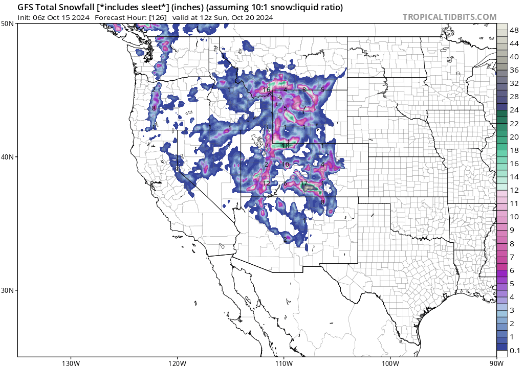
Below: Total snowfall in the west through early Saturday. We have high confidence in double digits for the northern coast ranges of BC, Moderate totals for Whistler (Higher elevations) with slightly less over Alberta and the BC interior (3-7).
The Pacific Northwest favors Mt Baker initially Wednesday with SW winds, however a shift to the west, and NW will push light to moderate totals into the central and southern Cascades of WA and Oregon by Thursday (2-7). The snow levels in the PNW crash to below pass levels. Cold air might formulate some convergence zones over Stevens Pass or Snoqualmie with westerly flow (Upside totals at the peaks).
Models are consistent in the southern Montana zones being favored with perhaps 6-12 inches over Big Sky and less for the Wyoming zones near Jackson (2-5). Other winners will likely be the Wasatch Range in Utah extending east into the Uinta Mountains by Friday morning (6-12). Some models for the summits of the Wasatch show upwards of 15 inches at upper elevations through Saturday (Thursday tease at the summit- Friday-Colder and snowing to the bases to 5500 feet- Saturday- Light snow). Southern Utah should top out with decent totals extending into northern Arizona resorts.
The 4 corners will see the heaviest snow from Friday to Saturday favoring areas that do well with Southerly flow (Purgatory). Wolf Creek is a wildcard who normally does best with SW versus S or SE winds), Red Mountain Pass. Telluride is a wildcard (unfavorable wind direction however with the low sitting overhead surprises can happen). Arizona Snowbowl will also grab moderate snowfall by Friday and Saturday. A few model runs show upwards of 12-18 inches for the summits of the southern San Juan Range in Colorado (Peaks).

Below: Closer view of totals per the American Model through Friday night. The wildcard in our eyes is the Wasatch with good confidence east of the Wasatch (Uinta Range) above 7000 feet. SW flow dominates this storm early followed by NW flow Friday morning (Better for LCC, and the Canyons side of PCMR). Winds shift more northerly Friday afternoon and Saturday (NE) which might limit snowfall on the western side of the Wasatch range. Elevations above 9500 will see the higher totals in the Wasatch. The ranges of totals at Alta should be from 6-16 inches with the lower elevation snow coming for Friday morning under NW flow. That wind shift to the N or NE might limit totals later Friday or Saturday.

Bottom Line: Major pattern shift later this week for much of the west with colder temps. Moderate snowfall over a wide range of the Rockies including Canada at upper elevations. Potential for double digits at some spots in Montana, Utah and southern Colorado (Upper elevations). Wildfires will be suppressed by Friday in Utah. Pacific Northwest grabs light to moderate snow Wednesday/Thursday (WA, OR).
SNOW TIRE ALERT: Please support our long term sponsor "Tire Rack" with some specials listed here There are multiple rebates on both all season and winter specific tires from this link. This might be a good time to put your snow tires on. Tire Rack partners with Discount Tire where your tires and wheels can be shipped.
Please support Powderchasers with a donation, Merch purchase, or sign up for our custom Concierge Powder Forecast Package where we provide 1:1 phone and email support to keep you in the deepest locations possible. Outside Magazine listed Powderchasers as in the top 3 sites with the custom concierge program. This supports us.
The extended period looks active in week #2 with a possible storm moving into the Sierra and a wide area of the Rockies.


