
October 31st - November 4th Forecast: Another Atmospheric River Slams British Columbia.
_______________________________________
Summary
_______________________
Another weekend storm rolls in Friday morning, driven by a deep low-pressure system off the coast of British Columbia. This setup will send yet another atmospheric river into both the coastal and interior B.C. ranges, with storm totals similar to last week. Whistler is poised to lead again, with around 2 feet at upper elevations, solidifying a proper base by Halloween. The storm begins warmer, with most of the moisture arriving before the cold front, and finishes colder, favoring higher elevations in the coastal ranges early, then shifting to the interior by Sunday night before the next system arrives on Wednesday. A ridge of high pressure over the Intermountain West will keep this storm north of the U.S., with the PNW seeing a rain event and the Rockies staying dry. Check the extended forecast, which indicates that snow will return to the West by mid-next week.
Below:
With high pressure anchored over the West, moisture is routed into B.C. and kept up there until mid-week.

Expected Snow Totals
________________________
Whistler:
- 14-20” (Above mid-mountain @5,500ft)
- 5-10" (3,500- 5,000ft)
- Trace-2" (Base area)
Mica Heli:
12-16” (Above 6,000ft)
Revelstoke:
- 6-10” (Above mid-mountain @5,000ft )
- Trace" (Base area)
Kicking Horse:
- 6-10” (Above mid-mountain @5,800ft)
- Trace" (Base area)
Lake Louise:
- 5-8" (Above mid-mountain @6,700ft)
- 2-5" (Base area)
Banff/ Sunshine:
- 5-7” (Above mid-mountain @6,700ft)
- 3" (Base area)
Fernie: 1-3”
Mt. Baker Ski Area: 3-5"
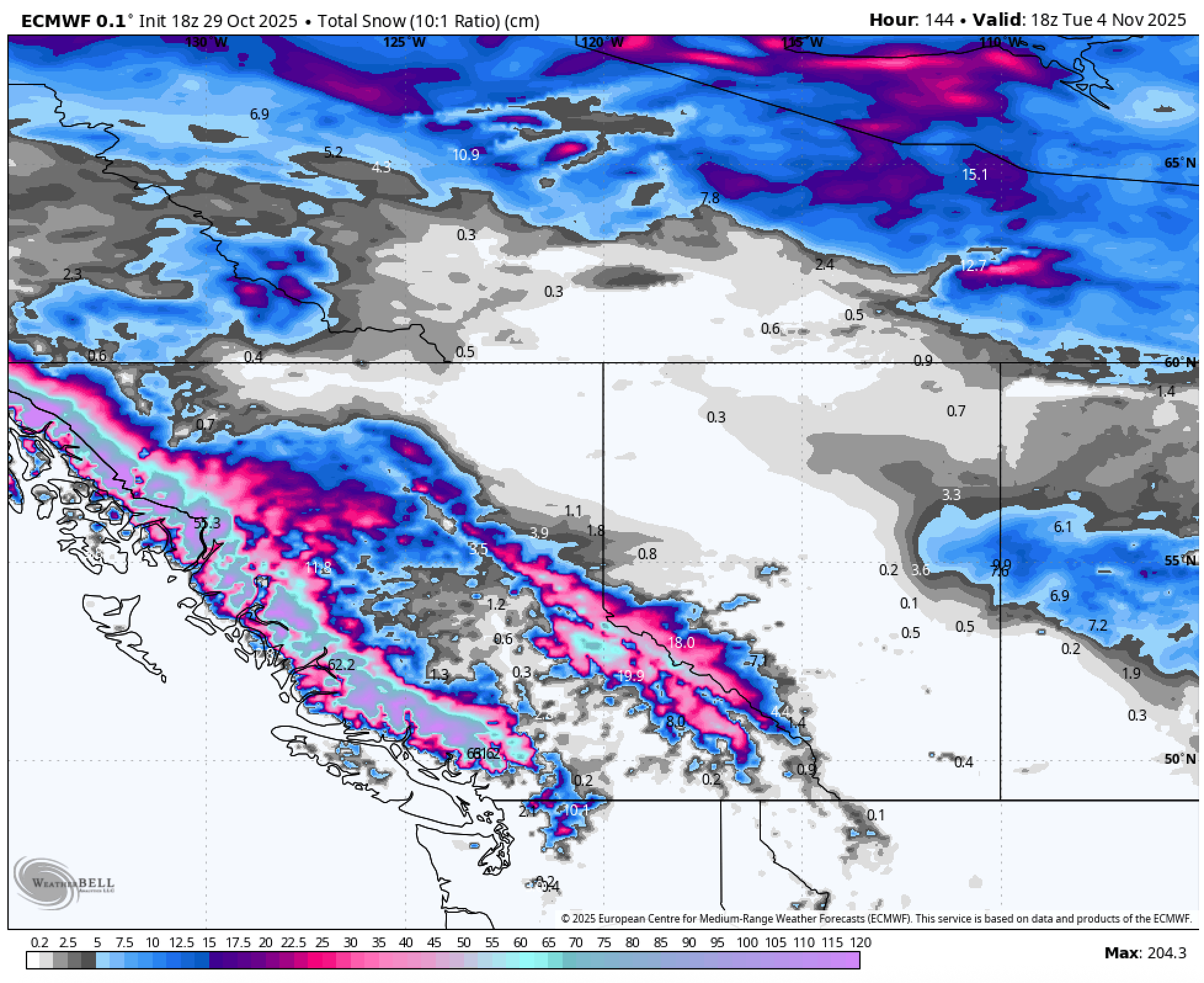
Below: Snow totals(cm) through Tuesday morning(11/4).
As the model indicates, coastal B.C. is favored, with totals up to 24" above 6,500 ft. Interior B.C. runs lighter overall but still performs in select zones, topping out near 10".
 Coastal B.C.
_________________
Coastal British Columbia is set for another long-duration storm beginning early Friday (10/31) and tapering Tuesday morning (11/5). The first wave will be the strongest as a deep low approaches the B.C. coast, delivering heavy snowfall to coastal resorts, with a bullseye on Whistler, through Saturday night. Snow will ease briefly before Sunday evening, when a secondary low develops offshore and continues to fuel the atmospheric river. Expect 1-2 feet in the Whistler area from the first wave, with most coastal mountains above 6,000 ft picking up 14–20 inches. The second wave, from Sunday night through Tuesday morning, is expected to add another 6 inches of snow across the coastal region.
Below:
Models show warmer upper-air temperatures, with snow levels around 8,000 ft, to begin on Friday. By midday Saturday, the cold front moves in, and snow levels drop 3,000 ft just above valley floors Sunday–Monday, before rising again to around 5,000 ft by Monday night.
 Interior B.C/ Alberta
______________________
Interior B.C. stays relatively quiet until midday Saturday, with the heaviest snow on Sunday. Snow levels will mirror the coast, hovering near 8,000 ft to start and not dropping until Sunday morning. Until then, many mountains may see rain even at alpine elevations. Storm totals should peak around 10" above 6,800 ft, especially in zones like Revelstoke and Selkirk Lodge.
Below:
The atmospheric river highlighted in dark red brings plenty of moisture, but areas below 6000ft (mid-mountain) will see nearly a full day of rain before a changeover to snow.
 Extended
___________________
The U.S. remains quiet through November 5, then snow returns to the PNW and Northern Rockies, as a series of small storms is expected to take over through mid-month. Canada remains highly active, with another long-duration storm approaching next Wednesday and continuing into the following weekend.
Announcement: Friday, October 31st, is the last day to purchase our Concierge (Custom chase forecasts and trip planning) at a significant discount. The discount ends on Friday at midnight.
Please support Powderchasers' free powder forecasts with a donation here or join our concierge program while it is on sale through October.

Forecaster: Mark Mazzatta


