
This is your final week to purchase a Concierge Package at a discount (Concierge provides custom chases and a deep powder guarantee). Rates go up on Saturday. Link here to grab the discounted rates.
The storm that we advertised last week favored the PNW, Canada, with the coldest temperatures and highest snowfall totals. That storm landed nearly 2 feet at upper elevations of western Canada, and 1-2 feet in the Cascade ranges. Amounts are based on telemetry and snow cams, which can be variable depending on elevations. The northern Rockies and areas of Idaho were favored Sunday into Monday.
Unofficial snow totals in the past 72 hours (Telemetry, Webcams, etc.)
Whistler: 23 inches
Whitewater: 6 inches
Mt Baker: 18 inches
Stevens Pass: 15 inches
Crystal: 12-18 inches
Timberline: 15-18 inches
Bachelor: 13 inches
Sun Valley: 8 inches
Brundage: 6-10 inches]
Jackson Hole: 8-10 inches
Grand Targhee: 10-17 inches
Alta: 2-3 inches
The big news of the weekend was the race to be the first resort to open this season. Keystone snuck in an early opening at 3 PM on Saturday, beating out A Basin that opened on Sunday.
Below: Keystone sneaking in an early opening on Saturday, 3 PM, October 25th.

Below: Stevens Pass ski area as of Monday morning. Woo Hoo! We estimate 18 inches at the summit.

Below: Grand Targhee in Wyoming with some skin tracks visible.

Below: Grand Targhee Stick of Truth (Base) showing 8 inches. Telemetry is showing near 11 inches at upper elevations on Monday morning.

Below: Sun Valley scored 8 inches by Sunday morning.

Below: Brundage scored 7-10 inches from the last storm.

Current Weather
Snow showers will continue in both the Pacific Northwest and northern Rockies on Monday. Cold unstable air is keeping the action confined to these areas on Monday morning.
Upcoming Highlights:
* Snow returns to BC and the Pacific Northwest Tuesday/Wednesday at upper elevations.
* 9-15 inches possible, especially in western Canada at upper elevations.
* Snow returns to the PNW again next weekend with a warming trend.
* Much colder air moves in later this weekend into early the following week at the tail end of moisture. More snow is possible in week #2.
Red Flags:
Snow levels rise initially during the next storm midweek (rain at lower or mid elevations of the PNW) with cooling on the backside. Saturday/Sunday storm will be warmer with rain possible at most base areas until colder air arrives late.
Storm #1 October 28-29 (midweek)
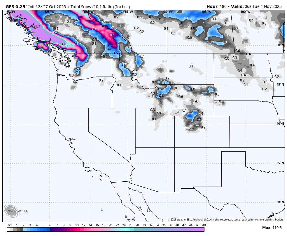
Below: Total snowfall from 11/28 ending Wednesday 11/29. 10-15 inches is possible, especially at mid or upper elevations of western BC, with 5-8 inches possible in the northern Washington Cascades (Upper elevations). The Cold front arrives late Tuesday night into Wednesday, improving the quality on the tail end.

.Below: This map runs from Tuesday, October 28, to Sunday, November 2nd. You can see the dates in the upper right corner. Cold front due Wednesday with warming again Thursday-Saturday. A colder air mass is seen at the end of this loop, Sunday (11/2), pushing further south into the Cascades and northern Rockies. Unfortunately, this cold air moves in at the tail end of the moisture train on Sunday/Monday.
Moisture for both systems comes in with the warmer air, and finishes colder (Base levels will see rain at times with flip-flopping snow levels).

Storm #2 late week storm- Friday 10-31-Monday (11-3).
Below: 24-hour snowfall totals from Friday (10-31) to early next week (11-3). The emphasis is confined to Canada, with some trickle down into the Northern and central Cascades of Washington. Some snow is also possible in the northern Rockies, but amounts look light. Snow will likely pick up again the following week with colder temps.

Below: University of Utah ensembles showing a mean of 5-10 inches midweek for Mt Baker, extending higher by Saturday/Sunday (November 1-2) with the second storm (Warmer).

Below: Snow to liquid ratios at Mt Baker dropping to near 5:1 (Wet snow at the summit, rain at the base) this weekend. Snow ratios improve to 10:1 later in the weekend with the cold front (10 inches per 1 inch of water)

Below: Snow totals at Mt Bachelor remain lower as the most moisture will be impacting northern Washington and Canada as oposed to Oregon.

Announcement: This is the final 4 days to purchase our Concierge (Custom chase forecasts and trip planning) at a significant discount. The discount ends on October 31st.
Please support Powderchasers' free powder forecasts with a donation here or join our concierge program while it is on sale through October.

Powderchaser Steve @powderchasersteve (Insta)


