It's a very busy morning in the weather center at Powderchasers. There are many chase locations this week.
Oregon and Sierra
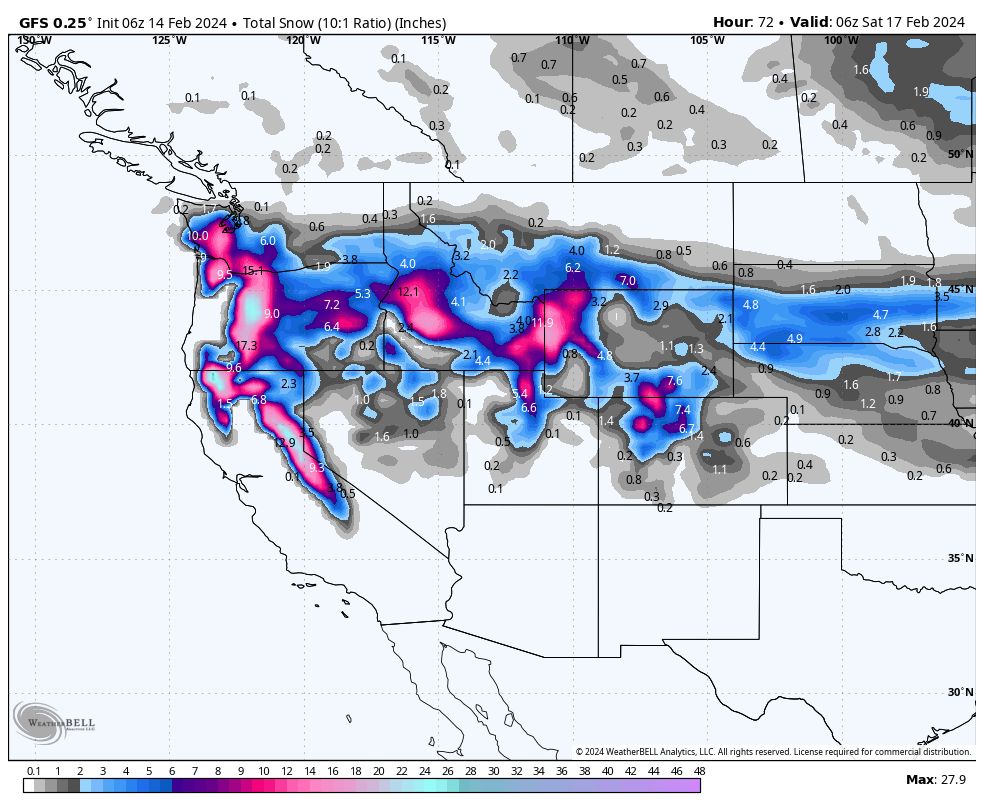
Very heavy snowfall will be occurring in Oregon stretching south into the Sierra range late Wednesday to Thursday. Oregon resorts will likely end up with 1-2 feet of freshies by Thursday mid morning. Snow levels are low starting at 700 feet but rising to near 2,000 (Might feel a bit upside down, but hopefully that medium dense layer helps to cover up the nasties below). With similar timing you can chase in the Rockies and Idaho for 1-2 feet of snow.
Below: 2 feet or more are showing up on the models towards the central Oregon Cascades near Bachelor with 12-18 inches possible elsewhere. Southern WA will see good snowfall near the OR border, but much less as you travel to White Pass or Crystal (Light or moderate snow).

The Sierra has very high confidence in our book for 12-17 inches above 7000 feet for most resorts around Lake Tahoe, with a bit less as you travel south to Mono County (Mammoth). Low-level snow will be in the 7-12 inch range. Bottom Line: Perfect timing for overnight powder for Thursday morning. Winds are a red flag late Wednesday through 9-10 AM Thursday with gusts to 90 MPH on the ridges (Might create snow quality issues at the upper peaks). Lifts will likely all be spinning by midday or earlier as the winds ease. Not much to lose on this chase.
Below: European model showing nearly an inch of liquid by Thursday morning near the lake, with a higher amount further north. 3/4 inch of central or southern areas of the lake. This would bring snow totals near 12-15 inches.

Below: American GFS is much more bullish for Tahoe with up to 2 inches noted near the lake (Northern areas favored). This would bring totals much higher to up to 20 inches or more of snow.

Alaska Alert! Alyeska just passed 500 inches for the season. Alaska Backcountry Guides in Valdez (Our preferred Heli Provider) has 2 open seats for UNLIMITED VERTICAL from 2/25 to 3/2. You will have cold pow from the alpine all the way to the Valley Floor. We have high confidence for conditions. As a bonus anyone that mentions Powderchasers when booking gets a free Concierge Package good until the end of next season! Only 2 seats left!

IDAHO, ROCKIES
Snow will push east Wednesday night, especially for central Idaho for 1st tracks on Thursday. The McCall area mountains will likely score 12 plus inches. This extends south to Hailey and eventually the northern tips of the Wood River Valley near Sun Valley (5-9). Timing: Thursday morning freshies.
The Tetons just scored 12 inches on Tuesday night (Overnight) with a hefty Valentines Day surprise. Additional snow will land in the Tetons late Wednesday night through Thursday (Storm ski) bringing an additional 12-16 inches to JHMR and a bit less for the western side near Targhee. Finally we can talk about a cold deep storm that will help the base areas around JHMR that have seen far less snow this season.
Montana is on the southern edge of the highest moisture with our forecast calling for 5-9 inches for Big Sky and Bridger Bowl. Similar totals might come in for MT Snowbowl and the eastern ID panhandle.
Peak snowfall for Utah will be 3 AM to 5 PM Thursday with likely totals in the 8-12 inch range. Areas north towards Beaver, and perhaps Powder Mountain, and Snowbasin might be on the upper ranges with the Cottonwoods coming up a bit lower (Moisture focus is from Utah County north into southern Idaho). Bottom Line: Snow reports might show 4-6 at 5 AM with 8-12 by 10 AM. Northern areas of the Wasatch Range might see higher totals, especially from Logan and north into the southern Idaho resorts that could be deep. Make last-minute moves on Thursday morning. Don't forget, Beaver Mountain has a new snow cam this season.
Moisture from the Tetons and Utah spread south into Colorado with some good numbers showing up on the models for Steamboat (Thursday midday to late PM). We would expect 9-12 inches or more for the Boat with generally moderate totals elsewhere to the south (3-7) towards I-70.
Below: Water totals through late Thursday night showing over an inch for the Tetons extending south into southern Idaho and the Utah border (Beaver Mountain, Pebble Creek ID). Decent totals in the northern Wasatch range extend to the Cottonwoods that are on the cusp. Provo and areas south see far less.

You might be able to chase from UT/WY to Colorado Friday and score twice. Or fly from the Sierra to Hayden Airport and score the Boat.
Extended:
Taking a quick look at the extended shows a trend of the AR's continuing for the Sierra with snowfall again this weekend and continuing with waves entering the Pacific every 24 hours. This will also accompany warmer temps with snow levels rising and fluctuating from 6K to 7K. I won't get into details just yet. Significant snowfall is possible for the Sierra as sum totals next week. Oregon appears to also get some action this weekend.
Each wave weakens and spreads northeast over the Rockies. It is unclear who gets the scraps, but currently, the Tetons and Idaho might stay on the strongest path.
Below: 24-hour moisture totals starting Saturday night through mid-next week showing a trend for moisture to continue in the Sierra, weaken, and spread north into Idaho, Wyoming, Utah, and northern Colorado. It's too early to forecast at this point. Several periods are on the models beginning this weekend.

Help us out!
If you want to chase powder with Powderchasers sign up for the concierge package for the deepest resorts to chase to and 1:1 custom forecasting with our staff. Also, if you have read this far, please donate to continue receiving these free forecasts. We appreciate the community support. You won't regret chasing with our custom forecasts. We have new swag on the Powderchasers storefront and all larger donations include it at no charge.
Enjoy the powder, everyone!
Powderchaser Steve @powderchasersteve on Instagram
Powderchaser Steve


