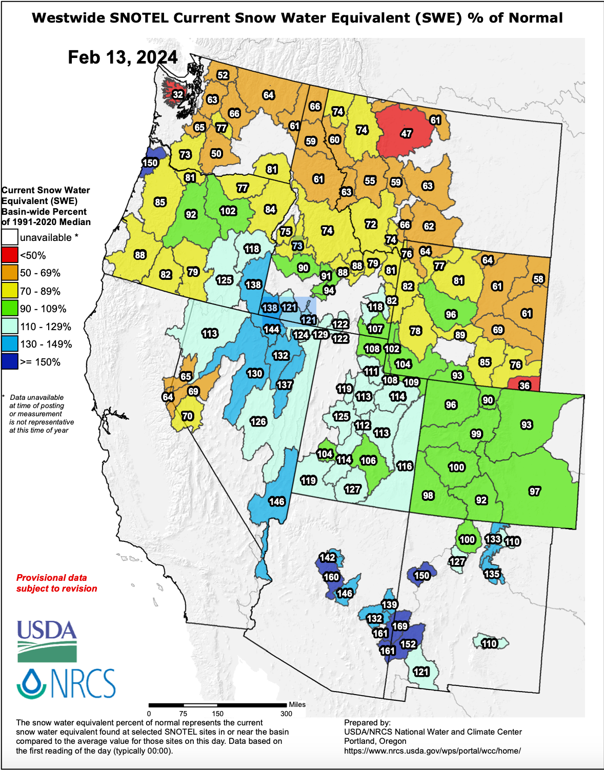
Following a very strange start to the season, the snowpack across the west is finally starting to heal towards normal values.
Below is Monday's NRCS snowpack analysis (February 12). This depicts automated station percentage of 1991-2020 median snow water equivalent:

When comparing this to the January 1st snowfall analysis in the GIF below, and you can really see how much things have improved, a result of a good January and particularly start of February for snowpack in the west. The pattern has allowed the snowpack to recover, and this pattern doesn't seem to be going away soon (more on this below).

There's still a lot of lost ground to make up, especially in coastal ranges like the Cascades and Sierra. The deficits in these regions are due to above-average temperatures so far this season bringing high-elevation rain with several large storms, which significantly damaged the already low snowpack they already had on the ground. Below you can see this coastal deficit but also encouraging numbers in Utah and Colorado. Southeast Montana, Idaho, and Wyoming have also had a rough season with tricky storm tracks skirting around the region (more on this below):

In the annotated precipitation percentage of median chart below, you can see the average storm track this season. Notice above average precipitation band stretching from Oregon into northern Nevada, Utah, and central Colorado, with below average precipitation to the north and the south of this band; this roughly depicts the average storm track so far this season:

Up north, Alaska is quietly having a very snowy season. Alyeska is currently sitting at about 125% of normal snowpack after an explosive start to the season (which has slowed down significantly since the first week of January).
Looking ahead, a more typical El Niño pattern is finally starting to kick in, resulting in a stronger subtropical Pacific jet bringing storms and moisture into the southwest US. This explains why the season in California has finally started to pick up a bit in the last couple of weeks.
Looking ahead, this El Niño pattern is expected to continue. Take a look at the forecasted 15 day precipitation anomalies from the European ensemble mean, which is keeping things very wet heading into the end of February for California and several other parts of the west including Utah and Colorado:

Beyond that, the models are undecided on March's fate; it could go either way. However, many models are indicating a wetter end to February before a drier pattern kicks in for early March (the first week or two). We'll have to wait and see how this pans out as the models converge on a solution, keep your fingers crossed for a wet spring so the snowpack continues to recover from a weird start!
Help us out!
If you want to chase powder with Powderchasers sign up for the concierge package for the deepest resorts to chase to and 1:1 custom forecasting with our staff. Also, if you have read this far, please donate to continue receiving these free forecasts. We appreciate the community support. You won't regret chasing with our custom forecasts. We have new swag on the Powderchasers storefront and all larger donations include it at no charge.


