Active Pattern Ahead: 10+ Days of Exciting Storms
We're looking at a very active pattern over the next 10+ days. There's a lot to talk about, so let's break it down.
NOTE: Please support Powderchasers with a donation, Merchan purchase such as a hat or stickers, or sign up for our custom Concierge Powder Forecast Package where we provide 1:1 phone and email support to get you to the deepest locations possible. Outside Magazine listed Powderchasers in the top 3 sites with the custom concierge program. These ways to support us will allow us to keep you chasing the deepest snow all winter! It's time to start trip planning and chasing pow! Coupon code POWCHASE gives you 15% off your Purl Wax order; we love Purl Wax for our snowboards & skis.
Storm #1: Northern California to Canada
The first storm is currently underway and has been bringing widespread rain, snow, and WIND to a large region stretching from Northern California up into the Canadian coastal range.
The first wave will be wrapped up in Washington & Oregon by Thursday night. Here are the ECMWF (left) and GFS (right) forecasts between Wednesday morning and Thursday night. Notice the GFS a little more aggressive in eastern Washington, while the ECMWF favors the Mt Baker region & northern Cascades a little more:

The other area that we're watching closely with this storm is, of course, California, where we're expecting a truly massive atmospheric river to stall over the northern part of the state. Precipitation is currently creeping its way into the state, but has yet to reach Tahoe; check out the current radar mosaic as of about 7am Pacific Time:

This precip will find its way into the Tahoe region later on Wednesday, really filling in around noon. This AR will come in several distinct waves, the first of which will last from Wednesday morning into Thursday night. Snow levels with this one will start at 5,000 feet and move up to 8,000 feet on Thursday afternoon/evening, meaning most resorts will see rain on the tail end of the first surge. Here are projected totals from Wednesday AM through Thursday night at mid-mountain elevations; keep in mind a lot of these totals will be significantly diminished and washed away by rain from the tail end of the system:
- Palisades/Sugar Bowl: 14-24"
- Kirkwood: 5-10"
- Northstar: 4-9"
- Mt Rose: 4-7"
- Heavenly: 2-5"
The next wave will follow on Friday morning and bring precipitation in the region through Saturday evening/night. Snow levels with this wave will start at 8,000 feet and drop to 5,500 feet by the end, decreasing basically linearly throughout the storm. Between Friday morning and Saturday night, here's what we're looking at for mid-mountain elevations:
- Palisades/Sugar Bowl/Kirkwood: 18-30"
- Northstar: 10-18"
- Mt Rose/Heavenly: 8-14"
- Mammoth: 12-20"
Yet another wave is possible from Saturday night through Monday morning/afternoon. Models are still a bit tentative about all agreeing on this one, but if it does materialize, it could bring another 10+ inches to some resorts, including Tahoe. Stay tuned for an updated forecast later this week with details as models begin to close in on what will happen. Here's the ECMWF forecast from Wednesday morning through Monday morning:

Idaho/MT/WY
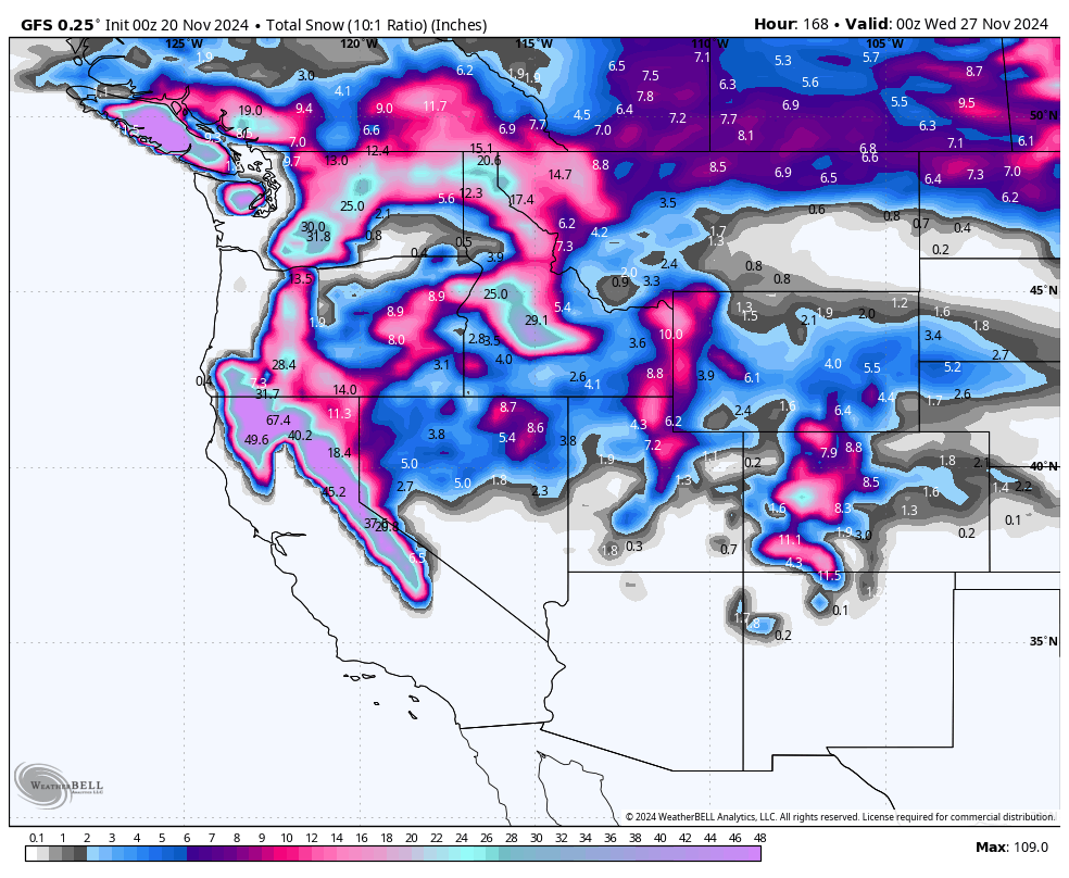
Idaho will be another hotspot from this series of storms. Check out the ECMWF and GFS forecasts between Wednesday morning and Saturday night; notice the surprisingly good model agreement in central Idaho with the GFS a little more aggressive to the north:

Sun Valley should see 12-18" and will end up being one of the biggest winners in this region during this period. We also have high confidence northern Idaho getting nailed, where Selkirk Powder Guides is located. We see them picking up 12-17" of snow, with some rain on late Friday afternoon. Big Sky should see 5-10", with snow lingering for a while on the tail end, where they could squeeze out a few extra inches.
The Tetons will be seeing steady moisture leaking into the region all week. It's likely there won't be very well-defined surges of snowfall, but rather small, steady waves that will keep it almost continuously snowing from Saturday morning (11/23) into next weekend (11/30-31)! We should be looking at 3-6" of snow per day at Targhee and 2-5" of snow per day at Jackson during this time. Check out the University of Utah downscaled ensemble plumes for this period, reflecting the probable nearly continuous snow during this period (9-15).

UT & CO
Details remain fuzzy for Utah at this time; models really haven't converged on a solution quite yet. Snowfall will begin on Saturday evening/night and last into Monday evening/night. By Monday night, we're likely looking at 10-15" for Cottonwood resorts and 9-15" for PC/DV. These numbers will change; there's a lot of time for the models to change around! More snow should arrive early Tuesday morning, but that's too far out to begin speculating on totals.
In Colorado, we're looking at snowfall from Sunday night into Wednesday morning, likely favoring the northwest mountains. The ECMWF keeps things mostly relegated to north of Crested Butte, while the GFS spreads out the snow a lot more and puts an absolute BULLSEYE on the Elk Mountains near Aspen: The American GFS is showing less snow.

There's still a ton of uncertainty here, so we will have updated totals for this system in CO over the next couple of forecasts this week.


