Summary: An active pattern continues for the upcoming week, with the Pacific Northwest leading the initial moisture train Monday through Tuesday. The northern Rockies, including Idaho, will score double digits. Another very strong wave hits the west Tuesday through Thursday and provides a more southern track from the PNW to the Sierra. The northern Sierra could be deep. Water totals this week are very high. Coupon Code POWDERCHASERS gets you 50% off your Xevo Optics goggles, which are the goggles we wear in the powder.
Powder Forecast
On Sunday morning, Mt. Baker telemetry recorded over 20 inches of new snowfall (24 hours). The temps were just cold enough in the northern Cascades while the central and southern regions in Washington, including Oregon, had snow levels skyrocket to 5-6,000 feet (Mainly Rain). Most precipitation focused on the northern Cascades and Canada under SW flow on Sunday.
On Sunday, colder air had worked south over Washington and Oregon by midday, increasing snowfall. As of late Sunday, 3-5 inches have fallen in areas from Stevens Pass Ski to Oregon, where snowfall intensity is increasing.
The winds are veering a bit more westerly Sunday night/Monday, which will help kick off some impressive totals for the Central Cascades (I-90 Corridor- Alpental, Stevens). Expect 9-15 inches for these areas into Monday. Westerly Flow is not as productive for the northern Cascades (Mt Baker); however, the models still show decent totals on Monday (4-8). The models also show very good totals for the Oregon mountains, with perhaps 12-20 inches near Mt Bachelor.
Below is a short-term High-Resolution model showing snowfall from Sunday night November 17, to early Monday (November 18). The action moves a bit further south than our previous wave on Saturday night. Temps have also fallen, with snow levels dropping to near 2000 feet. Oregon looks very deep near Bachelor. Stevens or Snoqualmie will pick up high totals if a convergence zone forms with westerly flow Sunday night. Monday will be a powder day!

Below: Moisture will move southeast Monday morning and provide heavy totals for the Panhandle of Idaho, Western Idaho (Brundage), Boise area mountains, and eventually the Tetons, peaking midday Monday to Monday night. The Teton range will likely grab 9-14 inches by Tuesday morning (Targhee and JHMR; Teton Pass should do well with this storm). Many areas of Idaho will see similar or higher totals.
Below: Very cold temps at 4800 feet (-5C or 23F). Snow levels are at 2,000 feet in the PNW.

Below: Total snowfall through Tuesday morning in the west. The Wasatch grabs lighter totals than its neighbors up north with scraps into Colorado. Areas further north, especially the Cascade ranges, will grab significant totals. Southern BC interior (Fernie) could also score on the Alberta border. Western BC grabs lighter totals.

The next powerful system moves ashore on Tuesday/Wednesday and might drop south into the Sierra! Keep reading if you like deep powder.
Below: The next storm Tuesday night for the Cascades raises snow levels slightly, with some warmer air that appears to be confined to the western portions of Oregon. Cold air near the passes in Washington will keep the ski areas colder, with respectable snow levels (you can see the line of warm air just west of most ski areas in Washington). Trapped cold air at the passes will keep temps lower.

STORM #2 Getting deeper and perhaps the Sierra wins a big dump?
Below: Storm #2 moves into the PNW Tuesday PM, spreading ample moisture south. The Sierra might score on this storm! You can also see moderate totals moving into Idaho. The big difference with this storm is southerly winds that help areas of the southern Cascades (White Pass, Crystal) and the interior near Mission Ridge. Areas near Spokane and north to Sandpoint might also score. South or SE winds are also favorable for the Wood River Valley (Sun Valley). The coastal areas of California appear to have significant water totals, with some flooding possibly occurring.

Below: Winds in the PNW from Tuesday night to Thursday's storm are southerly before veering southeast. This might crank out some decent totals to the inland areas of Washington near Mission Ridge and, with higher confidence, Crystal and White Pass. You can see the wind bars (S and SE) from late Tuesday night to Thursday morning on the map (Right side corner has the time and date).

Below: The European model below shows a good swath of moisture entering the Sierra mid to late this week and working south of Lake Tahoe. The GFS on the 2nd map below keeps higher totals on the north side of the lake.


Below: Total moisture per the GFS model through Sunday, November 24. I am not sure what to believe with this map showing up to 18 inches of water for the NW coast of California. Very significant water totals are also noted in Oregon, and Idaho, however some of that moisture is from Storm #1 early this week.

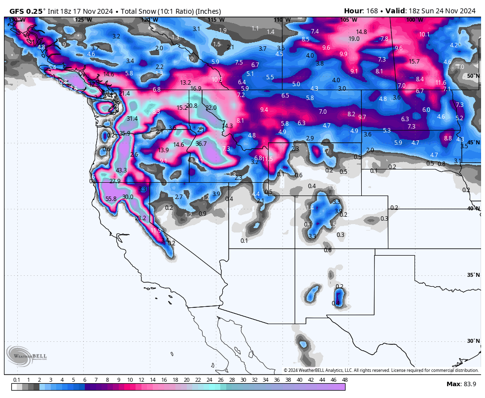
Below: Total snowfall at 10:1 through Sunday, November 24. These totals could be higher with the colder temps. The central and southern Rockies are left out of the major action.

Chases: PNW Monday. Idaho or the Tetons on Monday and Tuesday. PNW Wednesday. Sierra Thursday or Friday.
Please support Powderchasers with a donation, Merch purchase such as a hat or stickers, or sign up for our custom Concierge Powder Forecast Package where we provide 1:1 phone and email support to keep you in the deepest locations possible. Outside Magazine listed Powderchasers as in the top 3 sites with the custom concierge program. This supports us and keeps you chasing the deepest snow all winter. It is time to start trip planning and chasing pow! Coupon code POWCHASE gives you 15% off your Purl Wax order. We love Purl Wax for our snowboards.
You can follow Powderchasers on social media @powderchasers on FB and Insta.
Powderchaser Steve @powderchasersteve
You can also follow me on OpenSnow on the "Chase Powder Forecast"
Forecaster: Powderchaser Steve


