
The incoming storm will be a complete game changer for many ski areas in the PNW and north/central Rockies. Epic amounts of moisture through Monday. The red flags for chasing are rapidly warming temps in the PNW and upside-down snow in the Rockies with AVY concerns. Ski Areas will be deep! Game On! This is what we have been waiting for.
If ski resorts were open currently, we would be chasing immediately to the PNW for deepness early this weekend followed by a chase back to the Rockies (ID, WY, UT) for Sunday. Our chase would keep us pondering pow in either Wyoming or Utah for Sunday morning and perhaps Colorado for late Sunday to Monday. We would easily be able to score 60-70 inches total by chasing 3 States from the PNW to the Rockies.
Support our gold sponsor Tire Rack for the latest deals on snow tires and wheel packages for our chases. Discount Tire owns Tire Rack so you can ship and install locally.
Atmospheric River funnels several rounds of moisture for the west, pumps out 6 inches of moisture for the PNW, and decays as it moves east over the Rockies. This system has associated rounds of cold fronts mixing with the warm moist AR. The timing of the cold pockets and warmer air will make a big difference in snow totals. Strong winds and warming will increase avalanche danger significantly in the backcountry, especially by Sunday.
PNW
Very cold temps will keep snow levels low for the Pacific Northwest Friday/Saturday (3,000 feet) with widespread snow totals in the 12-20 inch range by Saturday morning. Some areas closer to Mt Rainier (Southern Cascades) extending south to northern Oregon could see 2- 3 feet primarily at the peaks. This storm has W, NW flow that often can pump out big totals for a wide area of the Cascades (Aside from the interior). we would put a bit more emphasis on bigger totals from Stevens Pass, Snoqualmie Summit, and south to Crystal, White Pass, and areas of Oregon. The Good: Significant snow totals at the bases through Saturday afternoon. The Bad: Strong winds will impact upper lifts. Warming Saturday through Sunday with rising snow levels. The warm front will spread into Oregon early Saturday with denser snow and a possible change to rain below 3500 feet. In Washington, the warm front impacts southern areas after daybreak while temps further north stay a bit cooler. Rain is likely from late Saturday night to Sunday in many areas of the PNW with some brief colder air pockets moving back late this weekend, especially near Mt Baker. Bottom Line: Great base building storm for the PNW and resorts will be opening with solid numbers. Bring your Gortex late Saturday or Sunday. What, if any resorts are open?
Below: Snowfall totals through Saturday morning. Higher totals might be confined to the summits with warmer air noted, especially in Oregon later Friday night or Saturday morning. Many big winners with this storm with decent base-level snow.

Rockies
The strong AR from the PNW will advance into the Rockies on Friday. A separate storm will be underway in Colorado that kicks light or moderate totals favoring the San Juan Range from Wolf Creek, CB to Aspen (2-6 inches fresh for Friday turns). "Not a big event, but with colder temps could sneak out some surprises"
There are 3 waves of energy that impact the Tetons, Panhandle, Idaho, Utah, and Colorado. On Friday AM snow will be falling at most of western Idaho, Wasatch, and the Teton resorts. .25-.40 inches of moisture with colder temps could land 5-11 inches of high-quality pow for many areas by late Friday (Last chair).
The 2nd fetch of moisture impacts these regions again on Saturday and pushes a bit further north into the Panhandle of Idaho and northern Montana, as well as decent totals for the Wasatch and Tetons (Colorado is a wildcard with moderate snow noted and decaying moisture). Wave 3 hits the Rockies on Sunday.
While not getting into details on the timing of each wave being 4-5 days out we will highlight a few deep spots.
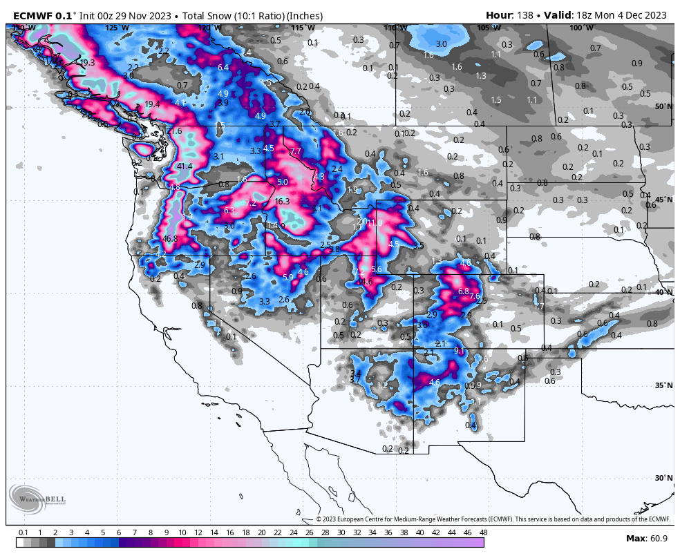
Below: Total snowfall through Monday morning for the west. These totals might exceed the map at 10:1 (10 inches for 1 inch of water), especially the Rockies who will see cold temps initially with an average of 50% more snow (15:1 or higher snow ratios initially falling to 10:1 late). Timing: The northern Rockies from Idaho/Wyoming and Utah score Friday AM-Saturday AM and again Sunday -AM/PM (3 events peaking at daybreak each day). Averages of 7-11 inches per wave. There will be short-lived breaks between each wave. High winds and warming are likely with waves 2 and 3. Saturday may stay cold in the Rockies with general warming late Saturday and Sunday with the final wave (slightly denser snow).
The Wasatch storm totals exceed 25-35 inches (Northern regions near Ogden (Snowbasin, Powmow, and Logan (Beaver Mountain). Park City is likely going to hit 20 inches.The Tetons will likely be in the 14-20 inch range, perhaps higher amounts at the summits by Monday (Slow ramp up with each wave). Less snow is forecasted for the southern mountains. Our longest running sponsor, Beaver Mountain will likely open after this storm!
Colorado scores a weak storm Friday in the central or southern mountains followed by moderate snow favoring the northern and central areas Saturday/Sunday.
Peak snowfall in Colorado comes from PM Sunday to Monday with 5-11 additional inches likely from Steamboat (Higher totals) extending south to Aspen, and most of the I-70 corridor (Western areas are a bit favored with Summit and Eagle in the card deck). Some areas in Colorado might score storm totals in the 10-18 inch range, especially western I-70 (Beaver Creek) perhaps Vail Pass, and higher confidence for Steamboat or even Snowmass (Combined totals from Friday to Monday).

Below: 10K foot temps rising as a cold front slowly decays first in the PNW Saturday (South to north) bringing rain to most ski areas later Saturday and Sunday. In the Rockies temps slowly rise later Saturday to Sunday increasing density. The map is from Friday evening ending Sunday morning.

Below: U of U models using the GFS model depicting nearly 3 inches of liquid for the Cottonwoods. You can see 3 waves from Friday AM, Saturday, and again on Sunday. Each wave is progressively stronger with snow ratios decreasing with warming late Saturday. Snowfall totals could exceed 30 inches. Some models show higher totals near Ogden and Logan.

Bottom line: Great base-building storm for many areas of the west including the PNW. Cold to warm. Increasing winds and avalanche danger (Don't venture into the Backcountry without the proper skills. Equipment alone does not mean you are safe). Some areas will grab 3 feet of snow. The storm is spread out over 3 waves with each being a bit stronger as you head into Saturday-Monday. If it were mid-winter we would be doing a 3 State chase. Models can still change this far out!
ANNOUNCEMENT: Please join our powder concierge program to support powderchasers. This program provides 1:1 forecasting, chase locations, and custom trip planning to get you in the deepest snow with each storm. You can also donate on our website or purchase some swag to support us. This keeps the free forecasts going. Any Donations of $50 or more get you free swag (Shirts and stickers).
"The anticipation is almost as good as game day" "The Sierra unfortunately is getting grazed"
You can follow my instagram feed at @powderchasersteve for world travel and powder.
Stay safe everyone.
Powderchaser Steve


