HAPPY HOLIDAYS EVERYONE!
Quick XMAS Eve post: Snow is falling lightly over the Wasatch with models showing 4-9 inches likely for many spots from I-80 south. As of 9 PM Tuesday 3-4 inches had fallen at Park City and roughly similar amounts at Alta. Models show snow continuing through XMAS morning with perhaps another 4-7 inches by the time lifts open at 9 AM. Heavier amounts might fall south of the Cottonwoods towards Sundance (Provo) as the northern edge of moisture is having a hard time reaching the Salt Lake Valley. XMAS might end up being a sneak up powder day similar to what today brought with 9 inches at Alta (Creamy up top with only 2-4 inches low). Meanwhile in the Tetons they scored 8-11 inches Monday night into Tuesday especally at JHMR.
In Colorado, the models are bullish for 6-11 inches for Wolf Creek and perhaps Purgatory through noon on Wednesday. The southern mountains will the brunt of snow. Further north towards Silverton may only see 5-9 inches. Telluride might see less. Some snow will be falling on the western side of I-70 towards Aspen, Glenwood (Sopris Ski area) and perhaps Powderhorn near Grand Junction. Very little snow will fall east of the Eagle County line. Best ride times will be in the southern mountains Wednesday morning. Some light to moderate amounts is also likely for New Mexico resorts (Taos in the 3-6 inch range).
Below: Total snowfall per the HRR short term high-resolution models showing 10 inches or more for Wolf Creek (Southern areas) and less further north. Some surprises are possible on the western slope from Glenwood to Grand Junction but amounts should not exceed 5-7 inches.

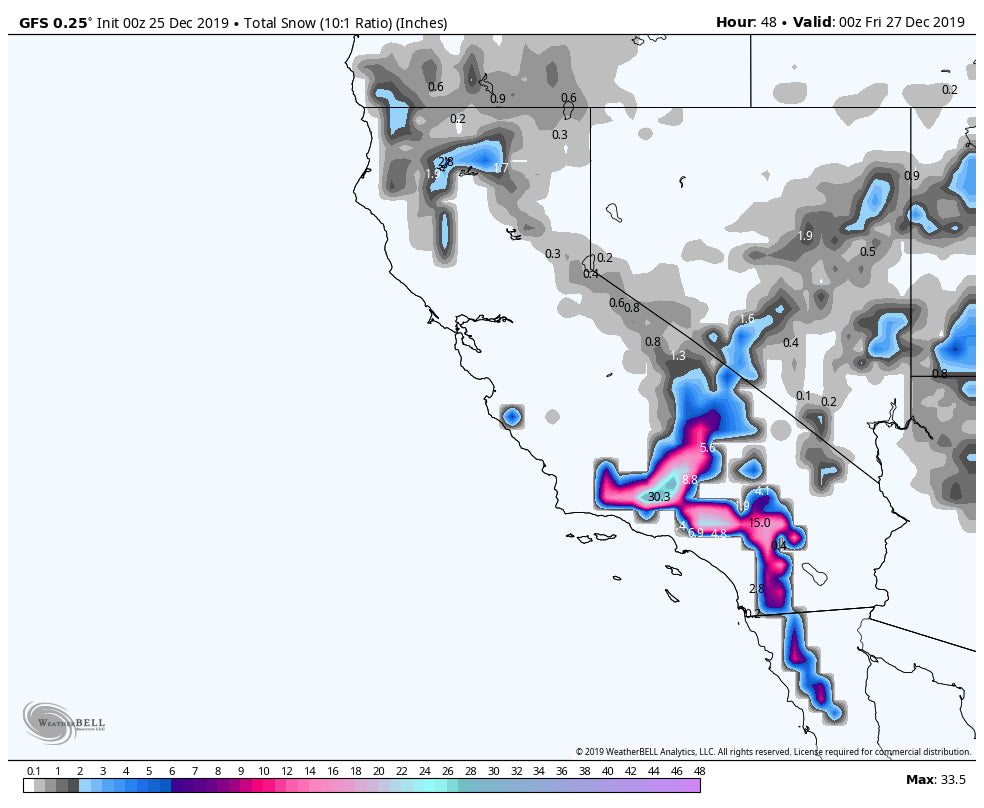
The BIG story this week will be southern California with a significant snow event and cold temperatures. This may land 20-30 inches outside LA in the San Bernadino Mountain Range (Mount Baldy will be deep). This may end up being a historic event (Wednesday night to Friday).
Below: Southern CAL will be DEEP late this week! Rare to see snow levels drop to 3500. WOO HOO

Other good spots to chase will be resorts near Flagstaff Wednesday-Friday where steady light to moderate events will add up to 12-18 inches this week. While no 6 hour period looks to hit double digits, the sum total will be respectable. Storm ski all week.
Once the southern CA storm exits by Friday, more moisture will drag south over Arizona and New Mexico. Taos may score deeper snow by Saturday.
CHASE? XMAS: Southern Colorado, Wasatch wildcard I-80 and south.
Thursday-Friday- Arizona, Southern California (CA deepest)
Saturday- Refresh for southern Colorado (Most moisture skirts south), New Mexico wildcards.
ANNOUNCEMENT
* Silverton Mountain opens for the season on December 26th with a 56 inch base*
Enjoy the powder everyone! Powderchaser Steve


