
A new system is entering the Sierra on Thursday morning and will traverse over the Four Corners into Friday.
Overall snow totals peaked out as or above our expectation, with the Wasatch Range topping the charts with 20-35 inches in 24 hours! Warmer density Graupel filled the skies on Wednsday morning with strong winds before the cold front hit late morning, and NW flow cranking out feet of fluff in Utah. Park City has finally nabbed a deep storm (20 inches) that also extended north to Powder and south to the Cottonwoods (30-35). While the Sierra scored 7 feet, overall storm totals are a welcome sight for many resorts in the West. The PNW snuck out 3-8 inches with Baker leading the way. More snow is on the way for the PNW.
Announcement: If you are flying in or out of Jackson, Wyoming, there is bus service from START Transit that will keep things green and save you money. This service runs all day with a link here. The airport has limited parking and encourages folks to use the direct bus from town.
Colorado did well in the forecasted areas with 18 inches near Aspen, and higher totals in the central and southern regions. Wolf Creek is reporting storm totals of 23 inches, with Purgatory not far behind. This was a great storm for many ski areas.
Sponsor Alert! Deep snow hit the Uinta Mountain ranges of Utah, where Park City Cats operates (Uintas). Please check out Park City Cats for some deep turns mid to late this week (0 lift lines and great terrain). Seats available starting February 24. You can link here. It will be deep and fluffy. Mention PC when booking for free swag.

Thursday to Friday
Snow is ramping up in the Sierra "again."
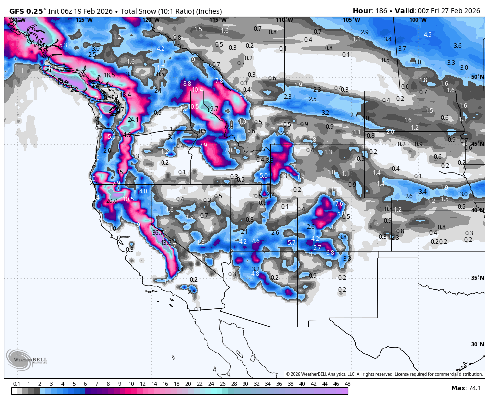
Below: Snow is filling in this map for the Sierra with 1-2 feet of storm totals that started Wednesday night and will continue into Thursday. We are expecting 9-18 inch storm totals for the Sierra Crest, including Mammoth, and 8-12 inches further east (Mt Rose, Northstar, Homewood). This is a very good storm to chase; however combines overnight totals into storm skiing on Thursday. The action swings south into the Four Corners by Thursday evening. Chase from the Sierra Thursday to northern Arizona, or southern Colorado or Utah for deep pow. Taos is a wildcard with around 6-8 inches.

The extended is active in the PNW and Canada later this week and again ramps up even higher totals at the end of the following week.
Below: While you can see the snow in the Sierra and Four Corners this week (Existing snow in the image), the map brings in additional powder for the PNW beginning on Sunday-Tuesday. Southerly flow might initially favor the southern Cascades (Crystal) and northern Oregon before a wind shift to the West. Northern Idaho is scoring powder as well as the BC ranges (Western areas are favored). This could be a 9-15 inch storm. Temps are cool enough, but it won't be blow.

Winds at 10K from Sunday night to Monday night
Below: High winds are likely Sunday into early Monday, especially in Oregon and the southern areas of Washington. This extends into northern Idaho on Monday. You can see the wind bars with stronger winds from the south switching to the west as the wind decreases late Monday evening. This could present some snow quality issues.

WHERE TO CHASE
Many options in the Sierra on Thursday, Wasatch with a trend to move south on Friday to the Four Corners. Many resorts in the Sierra have kept upper terrain closed, so Friday/Saturday might be a scoring day.
The weekend or early next week needs to be watched in the PNW and Canada for a moderate storm.
JOIN OUR CONCIERGE PROGRAM FOR 1:1 GUIDANCE, RESORT BY RESORT, FOR THE BEST POWDER (ON OUR WEBSITE).
Below: Looking out towards the end of next week, we can see 24-hour incremental totals highlighted for the PNW Canada that filters into Idaho and perhaps the Tetons and Colorado. The action in the PNW might start as early as Thursday next week.

Forecaster: Powderchaser Steve @powderchasersteve (Instagram)
HELP US OUT- Please support your love of powder and our free forecasts with a donation here, or join our concierge program. We have merch on the website.
We appreciate the support for these free forecasts.


