
A significant storm continues to impact the Sierra. You can score deep turns there all week! Storm totals through Wednesday will be in the 60-75 inch range above 8K. Valley totals will range from 2-4 feet, peaking on Tuesday.
Today, (Monday) features storm skiing that started up north (Sugar Bowl reported 5-6 inches) and is now heading south into the central Sierra. 12-15 inches will land in the Sierra by late Monday. Snow density will be medium to dense at the bases before a cold front due by later Monday. Storm ski Monday with the last chair being your deepest.
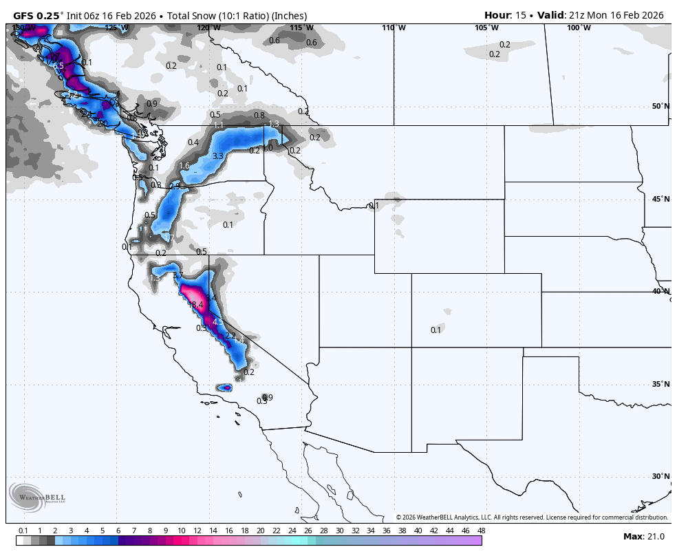
Below: Additional snow for the Sierra on Monday, filling in from north to South.

Storm #2- Sierra
The Sierra takes a quick but short-lived break Monday night before a much more substantial wave that cranks out significant wind and snow for Tuesday. This will likley bring many closures to both roads and some ski area terrain. Expect 2-3 inches per hour snowfall rates on Tuesday with 70-95 MPH Ridgetop gusts. Tuesday will be a full-on storm day with low snow levels.
Below: Moving map from Monday evening to Wednesday afternoon. You can see categorical high totals in the Sierra (5-7 Feet) by later Tuesday that wll be a full-on storm day, if you can find open terrain or roads. Snow is falling in Idaho, Tuesday night, and perhaps northern Montana and areas of Oregon. Utah gains the best storm ski day on Tuesday after 4 AM, albeit with strong winds. Colorado fills in Tuesday night into Wednesday (Four corners and central regions are favored, and perhaps Aspen or Steamboat wildcards). Chases for purely overnight snow might be better in Idaho, but the Wasatch will catch up by midday.

Rockies
A high-impact storm cycle lines up for Utah, Colorado, and the Northern Rockies from Monday night through Thursday afternoon. Strong south to southwest winds lead the charge, then snow builds in two primary surges, with widespread accumulation on Tuesday and a colder, higher-quality reload Wednesday into early Thursday. Expect wind scouring and drifting on exposed ridges Tuesday, followed by steadily better powder as temperatures drop and snow ratios climb.
Below: Wind speeds at 10K feet from Monday morning to Wednesday night. You can see several periods of extreme SW winds (brown and white) in the Sierra by Monday night/Tuesday that push into Utah and the Tetons Tuesday PM to Wednesday AM. The Four Corners seems to be in the windier cycle on a more consistent basis. SW winds migrate W NW at the end of this gif, Wednesday afternoon, resulting in a wind decrease for Utah and Wyoming and more orographically focused low-density snowfall.

Utah sits at the top of the depth chart, with the Cottonwoods delivering the biggest totals and the best midweek snow quality. Alta and Snowbird track near 25-35inches by Thursday afternoon, with Solitude and Brighton close behind. Southwest Colorado also performs, led by Wolf Creek near 28-40 inches, while northern Idaho and the Tetons finish strong with Brundage in the mid-teens to low 20s and Grand Targhee and Bogus Basin solidly in the teens. The pattern stays active past Thursday, but the next organized wave carries more spread in timing and where the core sets up.
Resort Snowfall Totals February 16-19
- Sierra Crest (CA/NV) 60-75 inches (Crest above 8K).
- Crested Butte, Colorado: 15-22 inches
- Eagle Point, Utah: 20-27 inches
- Beaver Mountain, Utah: 20-27 inches
- Park City, Utah: 17-22 inches
- Powder Mountain, Utah: 17-22 inches
- Wolf Creek, Colorado: 28-35 inches
- Brighton, Utah: 29-35 inches
- Solitude, Utah: 30-36 inches
- Alta, Utah: 25-38 inches
- Snowbird, Utah: 23-38 inches
- Sun Valley, 8-14 inches
- Grand Targhee, 9-15 inches
- Arizona Snowbowl, 9-18 inches
- Lee Canyon (Vegas); 11- 17 inches
Sponsor Alert! Deep snow is guaranteed for the Park City and Uinta Mountain ranges of Utah, where Park City Cats operates (Uintas). Please check out Park City Cats for some deep turns mid to late this week (0 lift lines and great terrain). You can link here.

Storm Timing and Discussion
Snow turns on first in the Northern Rockies Monday afternoon and evening, then pushes into Utah Monday night and into Colorado before daybreak Tuesday. The individual models line up well on the timing of that initial surge, and they also agree on a windy setup, with sustained ridgetop winds around 30-50 mph and gusts commonly 60-80 mph in Utah and parts of Colorado. That wind will move snow around through Tuesday, so protected terrain will ski best while exposed ridges take the brunt.
Colorado and much of the Northern Rockies see their most organized hit with the Tuesday front, and the individual models stay tightly grouped on the timing, even as they differ on exact intensity. Snow levels start higher early Tuesday, roughly 6500-7500 feet for parts of Colorado, then drop into the 3500-5500 foot range by Wednesday as colder air settles in. Brundage can reach about 17-24 inches by Thursday afternoon, and Grand Targhee and Bogus Basin land in the 14-20 inch range with snow quality improving as temperatures trend down.
Utah’s best production favors the colder Wednesday reload. The individual models agree on the timing, while they split on how much Wednesday outpaces Tuesday. The ECMWF, the GFS, and the ICON lean more heavily into the Wednesday peak in Utah, while the GDPS keeps more weight on the Tuesday pulse. Snow levels fall into the 2500-3500 foot range, and snow ratios climb into the mid-teens, bringing a much drier feel than the early part of the cycle. Alta and Snowbird track around 31-44 inches by Thursday afternoon, Solitude and Brighton sit near 29-42 inches, and Wolf Creek runs about 28-40 inches with plenty of blower windows once the colder air locks in.
Extended Outlook
Snow showers in the West hang on after Thursday, and a trailing wave remains possible Friday into the weekend, though the individual models show enough spread on timing and placement that confidence drops. Farther out, the broader pattern keeps the western storm track active enough to support additional reload chances, including a stronger-looking window early next week. Expect colder stretches to keep snow quality high in the Northern Rockies, while Utah and Colorado carry a higher chance for occasional warmer pulses that can lift snow levels at lower bases. The PNW gets very active again by next week.
HELP US OUT- Please support your love of powder and our free forecasts with a donation here, or join our concierge program. We have merch on the website.
We appreciate the support for these free forecasts.


