
We are in a very active period. A departing storm is over the Wasatch and Colorado, followed by another system spinning over Arizona on Friday morning. The AZ system moves east over New Mexico by Friday afternoon- Saturday morning. Canada gets very active this weekend. The Sierra fire hose will be wide open mid-next week with a storm that may crush some big numbers and eventually move into the Rockies.
DEAL ALERT: The Mountain Collective Pass, the world's premier multi-mountain pass, is back for the 2025-2026 season. The Mountain Collective lets you chase the best snow at your favorite mountains all season long. Buy your pass by April 27th and enjoy two exclusive benefits: a bonus 3rd day at the resort of your choice and special renewal rates available for returning passholders. Renew now for $639 and secure your bonus day!
Departing storm Colorado and Utah
Utah resorts scored big on Thursday, with some surprise highlights coming in from the southern end of the northern mountains (29 inches at Sundance) and high totals from Deer Valley Thursday, plus Powder Mountain about 30 minutes from Ogden. The Tetons got grazed (JHMR) as they sat north of the highest snow totals. Light to moderate snow is still in the cards on the models for northern Utah (Cottonwoods favored) on Friday. This was a very productive storm for Utah.
What Happened? Models initially showed SW flow that would have been more productive for Snowbasin, BCC, and in some cases LCC. Looking back at telemetry, winds veered due south for several hours Wednesday night, which always favors Sundance and Deer Valley. DV that both reported 11-14 inches (Higher than LCC). S winds also produced some good totals at Powder Mountain, which surprised me. NW flow kicked in Thursday night, providing a nice refresh for the Cottonwoods and areas near Parleys (PCMR-Canyons side).
Colorado performed close to our forecast, with most of the action on the western and southern ends of the State. I mentioned Aspen as a strong wildcard sitting on the northern edge of the moisture tap. Highlands reported 11 inches on Friday morning (24 hours). Crested Butte grabbed 11 inches, and mountains to the south reported similar totals (San Juan Range).
Chase Now!
The heaviest snowfall on Friday is noted in northern Arizona, where a chase to AZ Snowbowl will be deep. That system moves east by later Friday and will impact the northern New Mexico mountains Friday night to Saturday morning. Snow will also filter north into southern Colorado, favoring the eastern areas near Cuchara.
Below: Arizona Snowbowl as of 5 AM on Friday. Telemetry shows 12 inches thus far, combined with Thursday and Thursday night (Split 50/50), and it is still dumping. Finally!

Below: Additional snowfall from early Thursday to late Thursday will be plentiful over the Flagstaff area and resorts. These areas could grab an additional 5-11 inches Thursday, with storm totals in the 10-20 inch range. This would be a good chase for today!

Below: New Mexico and the southern San Juan Range are favored for Friday night to Saturday morning. The NAM short-term model is slightly less bullish for Taos and shows higher totals for Wolf Creek and areas near I-25 in Colorado (Chucara). Keep reading for other solutions.

Below: The European Model shows lower totals in Colorado and pushes higher totals south of Taos County too far east of Ski Santa Fe. This would result in less snow in Colorado and similar totals for Taos.

Below: The short-term HRR pushes good totals near Wolf Creek (Similar to the NAM at the top), but less snow for Taos with a push of higher totals east of these ranges.

Bottom Line: There is some uncertainty about the totals for NM and Colorado. Here is my official forecast based on blending these solutions for Saturday morning,
Wolf Creek: 5-9 inches
Purgatory: 1-3 inches
Cuchara: 7-12 inches
Taos: 4-10 inches (Boom or bust)
Angel Fire: 4-10 inches
Ski Santa Fe: 3-6 inches
Extended pow will be deep
A strong system associated with a warm front approaches the BC Coast late Friday night. Significant moisture will pound the western Canadian mountain ranges early next week. Temperatures are cold enough for snow to fall above 2300 feet with snow densities in the 8 or 9:1 range (the Denser side of the range). The upper mountain at Whistler could easily see 20-35 inches of snow during this period. Inland areas of BC should grab 6-12 inches.
Below: Total snowfall in centimeters through Monday, March 10th.. The coastal ranges will grab multiple feet (70-80CM) beginning Friday night—interior ranges land in the 12-inch range. The Cascades of Washington get into the action later Sunday or Monday with a decent quick shot of snow for the northern mountains near Mt Baker for late Sunday to Monday morning.

Looking out to mid-next week, a robust system will impact the west, moving into the Sierra with depth and transitioning east over a wide area of the Rockies. This might bring another good storm to the four corners regions mid-to-late next week as moisture streams north, even into Idaho, Montana, and the Tetons. It is likely the most profound totals land in the Sierra with multiple feet.
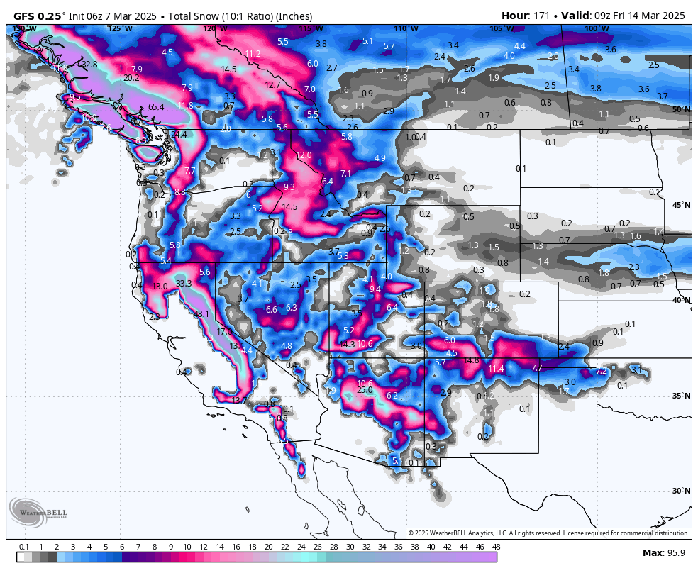
Below: 24-hour snow totals from Wednesday to Saturday, March 15th.

NEW FEATURE POWDER GUARENTEE: Powderchasers is excited to announce the "powder guarantee". This add-on to our concierge package guarantees that you will not pay for a "chase" unless we deliver on 50% of the forecasted snow. So how does it work? Purchase our two-chase package plus insurance add-on, then when you are within seven days of your target day in a specific ski region, we guide you to the deepest powder in that region, or we give you the heads-up that there will not be any significant snowfall for your trip. If we fail to deliver on our powder forecast by less than 50%, you get another chase free of charge.
NOTE: Please support Powderchasers with a donation, merchandise purchase (such as a hat or stickers), or sign up for our custom Concierge Powder Forecast Package, where we provide 1:1 phone & email support to get you to the deepest locations possible.
Forecaster: Powderchaser Steve @powderchasersteve on Instagram.


