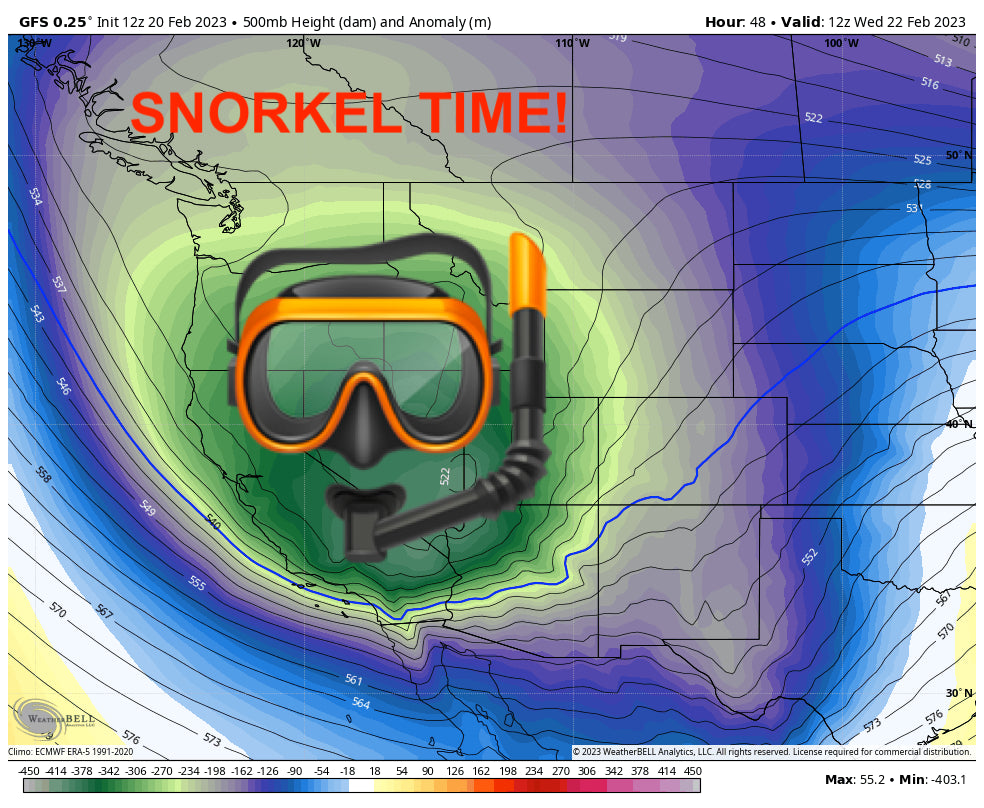
The West is in for an active week, with huge totals in the Tetons, Wasatch, Sierra Nevada, Cascades, and Rockies. You really can’t go wrong this week!
The first storm is already underway in the Pacific Northwest, Idaho, Montana, Wyoming, and northern Colorado. This is mostly moisture-driven with very little storm energy; most of the precipitation is orographic (driven by air rising up the mountains), meaning particularly intense snow bands are unlikely. Check out the high pressure over California steering the moisture down the storm track (clockwise):

This high pressure system begins to break down on Tuesday morning. This will allow more moisture and actual cohesive storm energy to spill south into the foreseeable future:

The first place that will benefit from this southerly shift in storm energy is the Cascades. After quite a bit of low and mid elevation rain on Monday, things should turn around on Monday night into Tuesday morning. Between Monday night and Tuesday during the day, I can see these the totals below being pretty realistic in the region. Keep in mind these totals will vary significantly with elevation, upper elevations will pick up much more snow. I am not including any accumulations from Monday in these totals (Warmer and wetter) but keep in mind that higher elevation resorts like Crystal and Baker could pick up a little more. Winds will be very strong Monday and Monday night with significant loading and avalanche risk increasing (Dense snow initially migrating to colder pow Tuesday). Colder air moves in after midnight Tuesday and winds stay strong in many areas through 10AM Tuesday.
- Mt. Baker: 14-19
- Stevens Pass: 10-24
- Alpental: 13-17”
- Crystal: 6-10”
- Timberline: 16-20”
This storm will bring lots of wind, so keep in mind that wind holds on upper elevation lifts are likely. Below is NBM wind gusts on Tuesday morning:

The storm will then continue to slide south, pushing moisture into Idaho, Montana, and Wyoming on Monday night and Tuesday morning. Between Monday night and Tuesday during the ski day, here are some plausible totals below. Winds will be very strong Tuesday morning especially in the Tetons with some lifts likely not spinning. Avalanche mitigation will be extensive.
- Grand Targhee: 9-15
- Jackson Hole: 12-20
- Big Sky: 6-8”
- Bridger Bowl: 5-7”
- Schweitzer: 6-8”
As the storm moves south, it’ll inch its way into California, bringing great snow to the region. The first wave will bring 5-10” of snow on Monday night. Winds may be strong enough to close upper mountain lifts on Tuesday. The main surge of moisture will be fairly gradual and spread out between Wednesday afternoon and Friday afternoon. Temperatures during this main wave be very cold and produce unusually fluffy snow - we’re talking snow ratios of 15-20:1 for the entire storm, which is what you’d expect to find in Colorado or Utah. Below are my forecasted totals at resorts around the region for each day (prior night snowfall plus snow that falls during the ski day):
THURSDAY:
- Western Tahoe basin (Palisades, Sugar Bowl, Kirkwood): 12-17”
- Central Tahoe basin (Northstar, Homewood): 5-10”
- Eastern Tahoe basin (Mt. Rose, Heavenly): 3-7”
- Mammoth: 4-8”
FRIDAY:
- Western Tahoe basin: 13-20”
- Central Tahoe basin: 7-12”
- Eastern Tahoe basin: 7-10”
- Mammoth: 12-18”

Above: NBM snowfall through Sunday morning.
Utah will also see huge totals, mainly on Tuesday afternoon through Wednesday.
- Cottonwood resorts (Alta, Snowbird, Brighton, Solitude): 20-25”
- Park City/Deer Valley: 15-20”
- Northern Utah (Beaver Mountain, Snowbasin, PowMow): 10-14”
- Southern Utah (Brian Head, Eagle Point): 10-14”

Thursday will bring another 2-6” and Friday will bring an additional 3-7” to Utah resorts, ensuring conditions stay fresh heading into the weekend.
In Colorado, Wednesday will be the first good day of a several stormy days. Here’s how Wednesday is shaping up around the state (Tuesday night + Wednesday day):
- Steamboat: 6-8”
- Northern Colorado (including I70 resorts): 3-7”
- Central Colorado: 3-7” (over a foot likely at Powderhorn)
- Southern Colorado: 9-18” (two feet likely at Wolf Creek)
Thursday will bring smaller totals but still excellent conditions:
- Steamboat: 2-4”
- Northern Colorado: 2-4”
- Central Colorado: 2-5”
- Southern Colorado: 3-6” (10” at Wolf Creek)
An additional final surge of moisture arrive on Friday:
- Steamboat: 2-4”
- Northern Colorado: 1-2”
- Central Colorado: 2-4”
- Southern Colorado: 3-7 ” (a foot possible at Wolf Creek)

Above: total snow through Sunday afternoon... wow!
Looking ahead at the forecast pattern, the next storm arrives next Monday. The storm next week looks very similar to this week’s storm; starting in the PNW, sliding down south and impacting California and the Intermountain West. Exact details remain to be determined, but it’s looking promising for another deep week next week as well!
ANNOUNCEMENT-
We fixed the link at Powderchasers! We are now offering some great apparel, featuring high-quality US-made beanies and sweatshirts. This store will be expanded in the future but we are offering pre-release pricing on some great items. Please check out our store and support us with some Powderchasers gear that supports our site: https://powderchasers.com/store.
Don't forget to join our Concierge program for custom chase forecasts or donate here. Our concierge program will provide you custom forecasts to insure you get into the deepest snow next week (Our chase secrets). Donations keep our free forecasts going. Members rarely miss the deepest days.
Thanks for following Powderchasers and enjoy the next few days if you dodge the winds and find resorts that are spinning upper lifts. You can follow @powderchasersteve on Instagram for updated travel photos.
Powderchasers Staff Forecast.


