
SUMMARY:
A cold moderate storm will impact the Rockies and PNW this weekend with good quality. A stronger Atmospheric River will impact most of the west from Monday-Thursday initially warm finishing cold. Several feet of snow will result in this storm over many areas of the west. Winds and initially warmer temps might impact a few areas especially the PNW initially.
Short Term
The short term offers some decent quality moderate snow noted for much of the Panhandle of Idaho (Ski Lookout), Montana Snowbowl (Near Missoula) extending south into the Madison Ranges, Tetons, and even northern Colorado (Rabbit Ears Pass) through Sunday. There are only .3-.4 inches of moisture noted in many of these areas on the map below, but with cold temps and good snow ratios, this could translate to a surprise dump into Sunday. The blues on this map are in the 1/2 inch range noted in the Panhandle of Idaho with some even higher amounts showing up in the mountains east of Missoula. Look for some moderate or surprise 5-10 inch totals for the Tetons and 3-5 for the Cottonwoods in Utah from late Saturday to Sunday. Bottom Line: Not much moisture but with cold temps, there could be some surprise 4-10 inch totals in some isolated areas that are hard to nail down. Good quality before it warms Sunday night to Monday and the approaching next storm.

The PNW will also see light or moderate snow favoring areas from I-90 and north on Saturday.
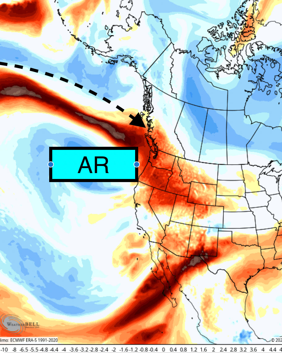
The action turns to the extended chase forecast with several options.
Extended:
A moist Atmospheric River will slam into the PNW Sunday/Monday and continue into Wednesday. This system will also have a good moisture tap for the interior BC regions that have not seen much snow this year. The peak intensity appears to be late Monday night into Wednesday. Temps will be warm initially (AR events are typically warm) with snow levels at 3500-4000 feet. This will bring dense snow to many mountains and even a bit of rain is possible at Snoqualmie Pass. Look for temps in the PNW to drop Tuesday morning (Still snowing) and quality to increase for what opens (Avy concerns, Strong winds). Quality improves further Tuesday night into Wednesday when temps send snow levels crashing to nearly 500 feet. My overall assessment is that the central and northern Cascades will grab the highest totals Monday/Tuesday with the southern areas of Washington and most of Oregon grabbing very good totals Tuesday to Wednesday. Winds will be very strong early next week with lift impacts likely until Wednesday morning. Wednesday could be all time for the entire Cascade Range of Oregon and Washington (1-3 feet) with the interior areas of BC grabbing 12 plus.
Bottom Line PNW: Very deep totals (3-4 feet) Monday to Wednesday. Initially favoring the Washington Cascades (I-90 and north) with 3500-foot snow levels. Strong winds Sunday-Tuesday. Colder Tuesday/Wednesday with significant snow spreading south into Oregon and to a bit lesser extent the Sierra (12 plus is possible for CA). Winds decreasing. Bring a snorkel in the PNW.
Below: Significant snow totals through Wednesday morning for the Oregon and Washington Cascade Range.

In the Rockies including Idaho, some big numbers will be on the menu for Monday-Wednesday. Look for 12-24 inches in many areas of Idaho and Montana peaking Monday night to late Tuesday. This will be a good storm for many regions from the northern areas of Idaho (cat skiing at Selkirk Powder), Whitefish Montana, and into the Madison Ranges to the south. Ride Tuesday to Wednesday for the deepest totals.
The Tetons grab the light to moderate cold appetizer this weekend followed by a moisture tap and warmer temps Monday-Tuesday. Temps are going to rise to -8C at 10K feet for late Monday evening (A bit upside down)- low 20's summits. 26-28 bases. Some surf is possible at mid to lower elevations. Total snowfall from Monday to Wednesday will likely be in excess of 3 feet. Quality will improve late Tuesday to Wednesday as the bulk of moisture heads for Utah in the latter period.
Below: Sharp cold front will merge with the AR and warmer air beginning Tuesday in northern Montana and northern Idaho and reaching the Tetons by Wednesday morning. Post-frontal snow showers could be heavy with the passage of this front.

Below: Good consensus on these tight lines for the models at JHMR for 3 periods of snow in the next 5 days adding up slowly to several feet by Wednesday. Temps are cold this weekend, warming Monday-Tuesday AM before sharp cooling Tuesday PM to Wednesday (Increasing wind and water load- Avy Danger rising). Map: the University of Utah ensembles SREF.

The Wasatch starts the main course on Tuesday morning with storm skiing and peak snowfall from late Tuesday to late Wednesday. Look for some deep totals in the entire Wasatch Range, especially Tuesday/Wednesday.
Below: Total snowfall for Park City Mountain (Summit). This was based on the NAEFS which tends to overestimate totals this far out. I would scale this down to the 20-28 inch range. 
Below: GFS output from the University Of Utah (only 1 model) showing a sharp peak of snow for Alta mid-morning Tuesday to late Wednesday. I would say 25-30 inches is a real possibility here.

Below: Big Sky ensembles are scattered from anywhere from 15-28 inches. Not as much consensus but high confidence in a significant storm next week.

For Colorado, snow intensifies Tuesday, especially in the northernmost areas, and peaks into early Wednesday. Winds are W and SW, and this will put some favorites into the western and southern corridor towards Aspen, Crested Butte, Silverton, Wolf Creek, and Purg, extending north to Rabbit Ears Pass (Boat). There is some indication of a band of heavier snow towards the Front Range just north of I-70 Wednesday so look for Eldora, or even WP to sneak out a surprise. The main I-70 corridor will likely see 5-10 inches (It's too far out for accuracy at this point). Southern Mountains or even northern spots near the Boat might grab 12-20. The temps are warm Tuesday so any higher-end totals might land at mid or upper peaks with less snow at the bases. Cold air arrives Wednesday morning that could produce some post-frontal heavy snow showers with great quality at the tail end of this event from Wednesday to Thursday. Northern New Mexico should score some moderate or higher amounts Wednesday.
So much to talk about! You might see me on the first chair Sunday.
Please follow my Instagram feed for powder and travel photos @powderchasersteve
ANNOUNCEMENT-
Powderchasers is now offering some great apparel, featuring high-quality US-made beanies and sweatshirts. This store will be expanded in the future but we are offering pre-release pricing on some great items. Please check out our store and support us with some Powderchasers gear that supports our site: https://powderchasers.com/store.
Don't forget to join our Concierge program for custom chase forecasts or donate here. Our concierge program will provide you custom forecasts to insure you get into the deepest snow next week (Our chase secrets). Donations keep our free forecasts going. Members rarely miss the deepest days.
Thanks for following Powderchasers!
Forecaster- Powderchaser Steve
PCS


