Summary: FINAL POST FOR THE SEASON
We pulled off the 20/21 season! If you chased powder there were several epic moments to be had that I will highlight in the forecast below. This is a sad moment in waking up to post a final forecast for the season. Significant snow is in the forecast for early next week for the Continental Divide from Wyoming to Colorado. Please donate to Powderchasers here if you want to support our forecasts for next season. Special thanks to our sponsors, Selkirk Powder, Ikon Pass, Tire Rack, Alaska Backcountry Guides, Indy Pass and Beaver Mountain. If you are interested in becoming a sponsor, please reach out to Powderchasers at powderchasers1@gmail.com
Forecast- Powder Alert! Colorado, Wyoming- Montana wildcards.
The previous storm exiting Colorado performed as forecasted with the final wave skimming southern Summit County with another 5 inches for Breck being reported Saturday morning. Snow totals came in as forecasted with up to 14-inch totals reported (Breckenridge). Light to moderate snow is still falling in the southern sections of Colorado and northern New Mexico. New England was hammered with 20 inches at Mount Snow and up to 15 inches at Loon Mountain (1 lift open). Remember, this is also coming off a 20-inch dump in Utah so it has been a very active close to the week. Reports in Colorado were mixed with some evidence of crust under the new snow, but if you happen to hit a groomer with the new snow on top, or the storm total of 15 inches in some areas it should be primo. But wait! There is another significant storm headed to the west dropping over Montana, Wyoming, and perhaps nailing the front range of Colorado by Monday afternoon. This is my last post for the 20-21 season. Keep reading for the annual highlights.
The upcoming storm will bring a very sharp cold front to northern Montana Sunday afternoon dropping decent amounts of good quality snow (4-8) from Whitefish, Missoula, Bridger, and through Wyoming. The Tetons get grazed with higher amounts further east or south over the Wind River Range. Higher amounts might fall near Red Lodge Mountain on Monday morning (Ski area is closed during the week).
NE winds (Upslope) will hammer the Front Range of Colorado Monday mid-morning to early Tuesday with moderate to heavy snowfall. Models are in decent agreement of 6-11 inches for the metro areas around Boulder with perhaps higher amounts for the foothills. Areas on or east of the Continental Divide will be favored with this storm. Some spillover into Summit County and Winter Park will likely land moderate amounts west of the Divide. This will be a cold storm with high-quality powder and road impacts likely from Denver to Fort Collins (You might want to leave your snow tires on).
Below: Snowfall totals through Monday evening for Montana and Wyoming. Favored areas will be Glacier National Park (eastern ranges), Red lodge Wyoming (eastern Divide), with light to moderate amounts over Whitefish, Bridger, Big Sky, and Missoula. The Tetons are just west of the highest moisture tap or orographics.

Below: Cold front slams into Colorado by Monday morning with -10C at 10K feet. Warmer temps will be found west of the Divide with light to moderate snow falling. Heavy snow is possible near the Denver metro areas north to Fort Collins by Monday afternoon.

Below: Total snowfall possible through late Monday night. Metro areas around Boulder or Weld County could do very well with this storm. Summit County will see some snowfall including Loveland Pass, and Winter Park however amounts might stay in the moderate range due to warmer temps, and NE wind directions favoring the Eastern Divide.
Check out the lowest offering from IKON above.

Farewell from Powderchaser Steve! Keep reading!
Please see below for my recap on the 20-21 season, highlights, and my farewell to all of you hungry powder hounds. This is our final post!
The 20-21 season brought the signature of La Nina which certainly played out for the Pacific Northwest and Canada as forecasted (Well above average precipitation). The season started out very cold in November, warmed somewhat in December, and finished with below normal temps in April (Powder was still falling). The below map of total water if you melted the snow shows the % of normal for much of the west. La Nina played out nicely (Cooler for the PNW and wetter).
Below: Snow water equivalent for the west showing up to 174% of normal for the central Cascades, near normal for the Tetons (JHMR logged 502 inches this season which is above normal), and just below normal for the Wasatch Range (The Cottonwoods are really close with 442 inches YTD for the Bird). Colorado has fared lower than normal, however, amounts closest to Denver (Front Range) are above normal (March Storm landed 2-4 feet for the metro areas). California is below normal (Not shown here).

HIGHLIGHTS FROM 20-21:
There were 3-4 storms that really stood out to me that I chased! The first was in Sun Valley when 50 inches fell in 3 days where conditions were deep as heck! Might be the deepest run of the season?
Below: Tommy the double pole planter scoring deepness in Sun Valley on January 29th. Photo: Luke Stone

Another epic storm to remember was the 34-inch day at Jackson Hole when the morning report was at 9-10 and by afternoon 34! One of my best days at JHMR in many years. @powderchasersteve via Instagram

And the grand finale was being stuck at Snowbird for 3 days of Interlodge when up to 100 inches of snow fell, the mountain opened and the roads remained closed. it was well worth the wait!
Below: 1st tram after 100 inches fell at Snowbird in 3 days (Post interlodge) Photo: @powderchasersteve via Instagram

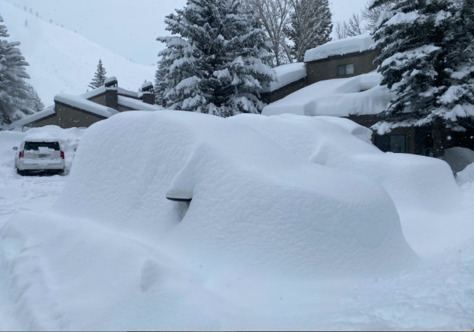
Below: \"Wheres my car\" - Alta Ski Area- Photo: @powderchasersteve- 105 inches.

Goodbye to all!
So I sign off this season with a special thanks to all that have followed the Forecasts this season, hopefully, scored powder or lived vicariously. Special thanks to our staff at Powderchasers including Blake Funston that remains behind the scenes posting social media. I post photos all summer from my adventures in travel so please follow Instagram @powderchasersteve. Our Concierge program is now open for the 2021-22 season. See you on the slopes! Stay safe!
Powderchaser Steve :)


