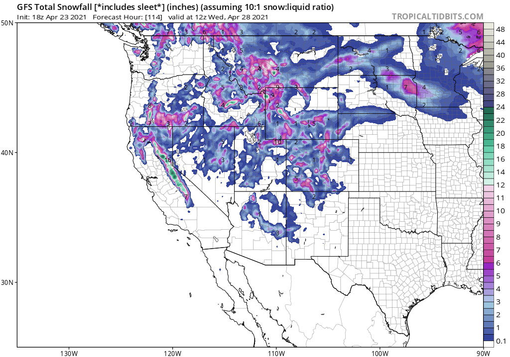
Just when we posted \final post\" there were a few comments that said \"I bet there's another one coming\" and sure enough they were right! Its hard to resist posting a powder alert when ingredients come together late season for some good dumps. That is exactly what is going to happen.
Powder days in the Sierra, Tetons, Montana, Utah, and Colorado late this weekend will bring snowfall into early next week.
Looking out further towards the 3rd or 4th of May (Week 2) the models are hinting at significant storm, for Colorado that could bring feet of snow to the mountains early that week. That storm is too far out to predict with much confidence-It's been showing up on models so worth keeping a watch out. Keep Reading for the 1-5 day forecast and opportunity to chase pow.
Announcement: For chasing powder we believe in having many pass options. Mountain Collective (23 resorts) is one of the passes we use.They are offering a bonus 3rd day free at your choice of resorts if you purchase this pass prior to Mid May. Rates also go up! This offer is available here at an affordable low rate that will continue all season. The bonus day expires soon. Mountain Collective is a new partner with Powderchasers so please link to them from our site to check out the latest offer.
Forecast:
In the short term, there is high confidence for 9-15 inches for the Sierra Range late Saturday night through Sunday evening. Snow and wind will be cranking after midnight Sunday as moisture begins to fall. The GFS which has been overly bullish all season shows up to 18 inches at the Sierra Crest and perhaps 4-8 inches further east. The European model has stayed in the 5-10 inch range. Plan on snowy travel on Sunday (Slush at Lake level) with my best guess for the highest amounts coming in in the southern lake mountains and Mammoth. Winds will ease at some point Sunday. While Mammoth might be deeper by midday Sunday, Squaw could still do well. Plan on 8-15 inches at the upper peaks of Mammoth by Sunday night and 6-10 inches at Squaw. Much less snow will fall at the bases. Winds and poor visibility might restrict what opens on Sunday (Plan to ride Sunday and Monday).
Below: Total snowfall late Saturday night to late Sunday for the Sierra. Higher amounts favor areas south of the Lake, however all regions above 7500 feet should see decent snow totals Sunday. (Mix of overnight and day snow). Look for new openings Monday. Strong winds Saturday/Sunday morning might impact quality or smooth buff some fun hero.

Below: Winds are strong at upper elevations of the Sierra Range Saturday to early Sunday as noted in the models at 10K. Sustained at 40-50 MPH decreasing at some point Sunday morning.

For the Rockies, a weak system will bring snow showers to many areas of the Rockies (UT, CO) this weekend before the main event arrives Sunday night to Tuesday morning. The models show double digits are likely for the Tetons (Higher elevations) peaking late Sunday night into Monday morning for the Tetons, and primarily a early morning to late Monday event for the Wasatch. Storm ski the Cottonwoods Monday and grab additional snow under NW flow (Colder) for Tuesday. Timing is not perfect with peak snowfall possibly coming early Monday and again early Tuesday. I think late AM Monday or early AM Tuesday have good potential (Total 2 day totals 8-16 inches). The Tetons might offer good touring possibilities but be sure to check the Backcountry Avalanche report before venturing out. Montana may also report some deep totals.
Below: University of Utah average of over 20 ensemble runs averaging out some precent decent totals for the Tetons Sunday to Monday.

Below: University of Utah ensembles also showing decent amounts for Alta (Closed) during the same period which might drag on a bit slower on Monday and into Tuesday.

For Colorado expect moderate snow for late Monday to late Tuesday. Models are showing decent amounts near Aspen, Irwin Lodge, Crested Butte (Wildcard) and further east near the Divide (Front Range, Loveland-AB, WP wildcard). Other mountain zones to watch will be northern Montana near Whitefish (Closed) for Sunday. Further south should land respectable amounts for areas near Bozeman and perhaps Big Sky (Closed) or Red Lodge Mountain (Closed)
Below: Dreaming of powder! Deterministic models are not very accurate 7-10 days out, but a significant storm is showing up for Colorado in the May 3-4 timeframe. Thats just a 2 day snowfall total! Dream the comes true after high pressure settle in mid to late next week.

Below: Global ensembles also show low pressure likely for Colorado in the May 3,4 timeframe

I once again bring you a final powder alert! Follow @powderchasersteve on Instagram for the latest adventures.
Enjoy the powder everyone! Living vicariously since I tore 2 tendons in my hamstring and will be out for at least 3-4 months.
Thanks to all our sponsors, Selkirk Powder Mountain Collective (Newest), Alaska Backcountry Guides, Indy Pass, Tire Rack, Beaver Mountain, and Ikon for a successful season. Please be sure to check them out! If you are interested In sponsoring your POW at Powderchasers, please reach out to us at powderchasers1@gmail.com. We believe highly in the sponsors we network with.
Also, if you scored powder this season please donate to support our forecasts for next year here.
Powderchaser Steve


