Happy Holidays! We are in the Powderchasers weather center watching a very progressive pattern approach the PNW and western Canada. Snow has already begun in the northern Cascades of Washington with Mt Baker already at 8 inches (Cold portion of the storm). Snow will intensify by 11AM Wednesday over the northern Cascades and western BC, eventually funneling south into the central and southern portions of Washington by 2PM.
This post is sponsored by Selkirk Powder (Avalanche education, Snowcat and backcountry touring). Selkirk Powder is located in northern Idaho and is just beginning to offer backcountry avalanche courses in their new expanded terrain. Decent snow totals are headed their way later this week.
Some projected snow totals through Thursday afternoon.
Mt Baker: 19-28 inches (Lower mountain sees the lower total)
Crystal: 18-26 inches
Stevens Pass: 18-26 inches (mid to upper)
Mission Ridge: 10-12 inches
Timberline: 18-25 inches
Bachelor: 9-14 inches
Whistler: 15 inches
Selkirk Powder: 12-18 inches
The below maps will provide a good illustration of the abundant powder days, winds, temperatures and areas to chase. The Rockies score including Idaho from Thursday to Sunday with several waves of snowfall.
There is currently weak leftovers moving from the Wasatch Thursday morning through both extreme northern Colorado and further south in the San Juan Range. The Wasatch is reaping rewards in the 3-6 inch range on Thursday morning. Some models show decent totals in the northern San Juan Range near Telluride or Red Mountain Pass.
Below: Snowbasin and Snowbird are all in the 5 inch range currently at press time. Snow will continue through mid morning albeit light.

Below: Steamboat Is scoring some light powder on Xmas Day! Santa delivered early.

Below: Total snowfall for the west through Thursday morning. You can see 3 feet plus for the Volcanoes (Mt Rainier). The Ski areas in both Oregon and Washington will do well (North Oregon is favored over the south). There are a few kinks however to this chase (Wind and Temps).

Below: Winds at 700 MB (10K) are very strong in the upper atmosphere aimed at the Oregon and Washington Cascades from Wednesday night to Saturday morning. There are some short lived breaks, but it will be very tricky to judge lift openings or snow quality based on these sustained winds. Lower atmosphere winds at 4800 feet are also strong (Sustained 30-35). The Rockies are also impacted with wind, especially with decent moisture taps Friday-Saturday (Some upper lifts might not spin).

Below: The next issue is temps in the PNW with 4800 foot temps near freezing (0-C) and occasional warmer air funneling from south to north (Above freezing with the reds and warmer colors). Oregon seems to be in a slightly warmer sector due to colder air pushing west from the interior Cascades of Washington (Cooler on the passes and warmer east).
While it is not cold in western Canada either the temps are a bit more respectable with snow levels ranging from 2K to 3K feet (Just above or near the bases). Wind combined with the generally warm nature of this storm will likely result in dense snow especially Wednesday night (Warming).

Below: Moving snow map from Thursday to Saturday night. You can see the track moving over Idaho with significant snowfall, especially the western mountains near McCall, and areas north form Ski Lookout to Selkirk Powder.
The other zones that will do well later Thursday to Saturday are the Tetons, Wasatch, and northern Colorado (North of I-70 will see the highest totals). The northern Sierra also gets into the action by Friday.

Projected Snow totals in the Rockies and Idaho through Sunday December 29
Brundage: 25-32 inches
Whitefish: 12 inches
Selkirk Powder: 12-18 inches
Jackson Hole: 24-30 inches
Targhee: 17-24 inches
Alta: 20-25 inches
Steamboat: 15-25 inches
Vail: 9-14 inches
Winter Park: 9 inches
Breckenridge: 7-11 inches
Aspen: 7-10 inches
Wolf Creek: 4-8 inches
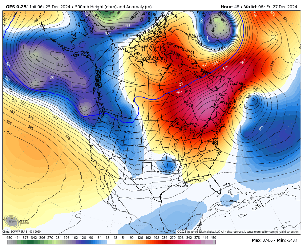
Below: You can see a continuous stream of low pressure systems moving from the Pacific into the west from Thursday to Tuesday (December 31).

Below: High pressure briefly fills into the west near the January 1or January 2nd timeframe, but could be short lived.

Below: Current models show a strong low pressure system moving into the PNW near January 3rd and possibly meander over the Rockies in the January 4th or 5th timeframe. This could be a good snow producer, but it's too far out to forecast with accuracy.

Bottom Line: Significant moisture headed to the west. Extremely windy periods, especially in the PNW that will trickle east at times over the Rockies later this week and weekend. Snow levels in the PNW are on the warmer side with relatively dense snow likely with these storms (Snow levels fluctuates from 3,000 to 4,000 feet in Washington with warmer periods noted for Oregon). Slightly cooler in western Canada and especially the interior (Light to moderate snow for the interior).
The Rockies including many areas of Idaho score deep snow from Thursday to Sunday. Most of the action for the deeper snow will be along or north of I-70. There is a warming trend for the Wasatch and Tetons with snow density migrating to early light on Thursday/Friday to dense by Saturday/Sunday.
Please follow our social media channels @powderchasers on Instagram and FB.
Powderchaser Steve. @powderchasersteve
Happy Holidays (Chanukah and Xmas) today- December 25th. Santa used the snow in the Sierra yesterday and successfully made it east!


