Before we get into the storm, we wanted to remind you that the rates for the Powder Concierge are going up in 3 days. The Powder Concierge is a service we offer that provides custom forecasts to help YOU ensure the deepest possible powder days. With everything going on with COVID 19, from reservations to travel restrictions to the fact that we all may ski and ride less days this season; getting the best conditions when we DO ski/ride is more important than ever. To sign up before the rate increase or to learn more about the Powder Concierge, click here.
Quick Recap: Fall is well under way in the West with the last storm providing moisture for the Northern Rockies late last weekend. The storm favored the northern Rockies with some teases further south into Utah and even the I-70 corridor in Colorado. Snow telemetry showed approximately 6 inches fell at the Summits of the Tetons. 5-6 inches fell at Loveland Ski Area. You should know from posts last season, we are big advocates for Snow Tires! Powderchasers has teamed up with Tire Rack this season. Click here for a comprehensive look at some specific custom winter packages!
Below: Snow in the Tetons last Sunday morning including the Valley north of Jackson: Photo: @powderchasersteve via Instagram

Below: Today at Revelstoke Mountain Resort in Canada- Amounts exceeded a foot as snow continued to bury the Gnome cam.

The next storm looks very promising for the northern sections of Washington with wet snow likely falling late Monday night into Tuesday. Areas in the NE Cascades will do the best (5-10 inches above 6,000 feet).Temps will bring snow levels as low as 4,000 feet early Tuesday before rising later in the morning. Further west, lighter amounts are likely from Stevens Pass to Mount Baker, however warmer temps will keep amounts on the low side. Areas of the northern Panhandle (Selkirk Powder Guides) will see light snow at the upper elevations.
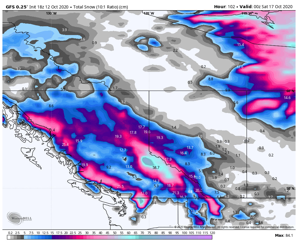
The biggest rewards are likely for spots of BC including Whistler at upper elevations and especially interior BC. Even Alberta will see snow falling early this week. If we were in chase mode, I would be headed to the NE Cascades, southern BC, and eventually central BC by the end of the week (More on that later). Too bad the Canadian border is closed! Locals will have it to themselves at least in the short term. There were folks out skiing at Revelstoke today per the webcams!
Below: You can see the coldest air is trapped in the interior of Washington favoring spots closest to the Canadian Border.

Below: Isolated area of very heavy snowfall for the highest peaks of the northeast Cascades. Much of this will be above most of the Ski Areas bases. Mountain Passes in the northern sections of Washington will be snow packed Tuesday morning.

In the extended forecast another decent shot of snowfall and even cooler temps are likely for most of British Columbia. Models are showing up to another foot likely at upper elevations by Friday. That system will likely drag a cold front with NW winds into the northern Rockies impacting Montana and areas of northern Wyoming by the weekend with a good chance of light snow. We may see a repeat of last weekend for the northern Rockies (An update will be issued in a later post).
Don't forget to check out our discounted pre season Concierge rates! Support our Partners! Welcome our newest partner, Tire Rack, that will get you to the slopes for first chair (See the winter packages in the link).
Also, the price of the Ikon pass will go up on October 14th, so make sure to lock in the lowest rate before then right here.
Welcome to the 2020-21 Powder Forecasts!
Powderchaser Steve


