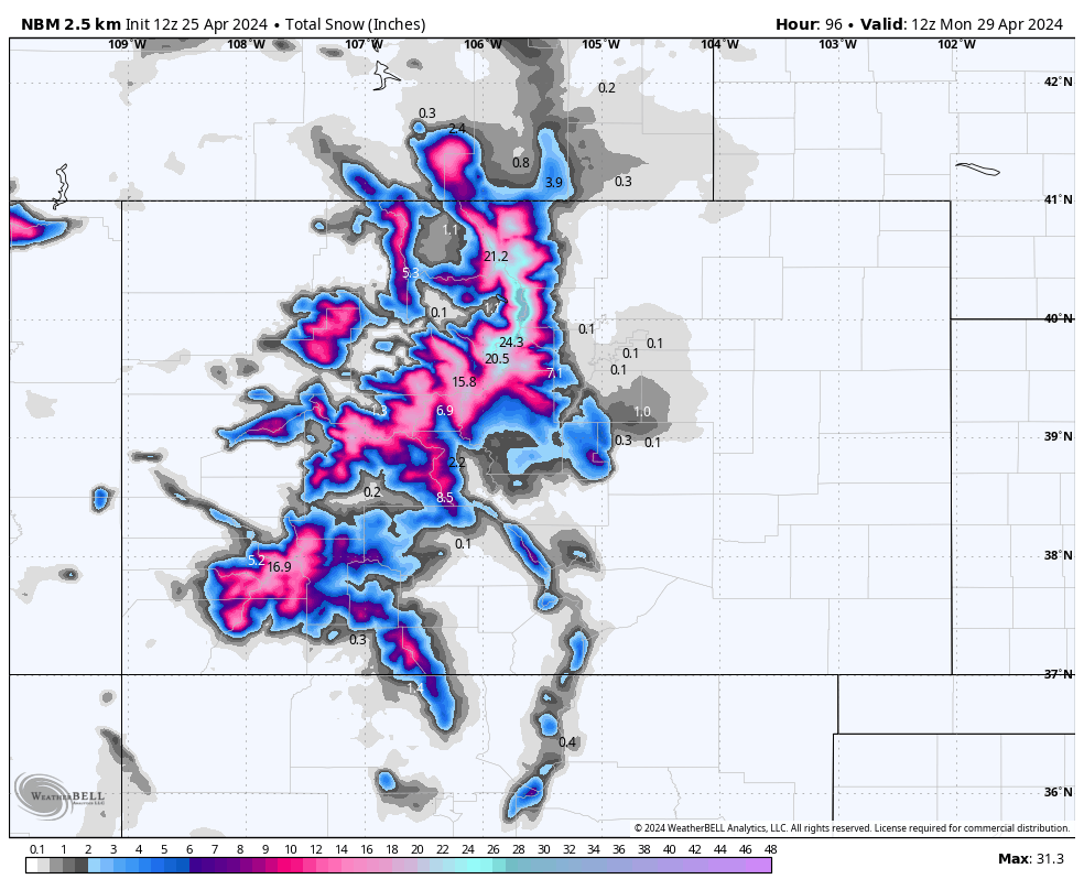
A significant late-season storm will sweep through Colorado this weekend, dumping over a foot at several resorts and up to 20" up high.
While our regular forecasts have ended, we will still be covering particularly notable systems in North America as well as South America and New Zealand once their seasons kick off in the coming months.
At Powderchasers, we thrive on sharing the thrill of the chase with you. If our forecasts have enhanced your powder experiences or if you enjoy living through chases vicariously, please consider supporting us. Every donation or merch purchase helps us continue our mission of free, frequent forecasts and chase reports.
Donate to keep the adventures coming: Donate to Powderchasers.
Or grab some swag—use discount code "spring" for a special deal on all shirts: Powderchasers Collection.
Before the forecast, here are all the resorts in Colorado that are still operating lifts (with their anticipated closing dates):
- Loveland – 5/12
- Arapahoe Basin – as long as possible
- Breckenridge – as long as possible
- Copper Mountain – as long as possible
- Winter Park (Mary Jane) – as long as possible
Precipitation will begin on Thursday afternoon, but won't bring much accumulation before this first wave ends on Friday morning. Snow levels will be high, above 10,500-11,500 feet for most parts of the state, meaning lots of lower and mid-elevation slopes will see mostly rain & sleet. Totals from this first wave won't be significant, just a few inches in the upper peaks. Below is the ECMWF forecast by early Friday afternoon; notice the highest totals in the central mountains and drastically differing totals favoring higher elevations:

The main wave from this storm lasts from Friday evening into Sunday night accompanied by colder temperatures and lower snow levels. This wave will bring incredible late-season totals around the state, favoring upper-elevations in the Front Range and San Juan (although everywhere will do fairly well). Due to marginal spring temperatures, the snow that does fall will be on the denser, surfier side. Below, you can see 700mb temperatures just barely allowing for mid and upper-elevation snowfall during the peak on Saturday. These are the temperatures at about 10,000 feet in degrees celsius:

Between Friday evening and Monday morning, we're looking at the following totals for roughly mid-mountain at each of the resorts that are still operating:
- Loveland (11500') – 10-16"
- Arapahoe Basin (11600') – 10-16"
- Breckenridge (11000') – 7-11"
- Copper Mountain (11000') – 7-11"
- Winter Park (Mary Jane) (11000') – 9-16"
Upper mountain totals will likely surpass 20" at many of these resorts. Note that depending on where the resorts measure their snowfall, reported totals may differ from these forecasted totals, which is why I included the elevations that these are for. This storm will be very variable by elevation.
Clearly, resorts closer to the continental divide and further east are going to be the best chase targets for this weekend. Snow levels will fluctuate between 8,000 feet and 12,000 feet (higher at the start) but will be around 9,000-9,500 feet for the peak of the storm on Saturday afternoon. Below is the Euro forecast by Sunday evening (it's missing a few more inches that will fall on Sunday night):

The best day of skiing during this storm will be Saturday and Sunday. Good luck beating the horde of I-70 nomads finding their way to deep turns this weekend...
Elsewhere, Utah is also getting snow this weekend. Snowbird should pick up 10-15" between Thursday night and Saturday night. It will be slightly cooler in Utah for this storm with the peak odds of less cream and a bit more medium density snow being on Sunday morning.
In the Pacific Northwest, unusually cold temperatures will allow snow levels to drop down to about 3,000 feet. The best snow will fall in Oregon, specifically at Mt. Bachelor and Mt. Hood, which should see 8-14" of heavy snow by Sunday morning. The snow quality at Bachelor will be better, so we recommend that as the best chasing opportunity this weekend in the Pacific Northwest. Below is the ECMWF snowfall forecast for the region:

Another cold storm looks like it could creep in and bring significant totals to the region – especially Washington – early next week. Stay tuned for potential chase opportunities early next week, especially Monday!
Happy chasing!


