Just when we thought we were done posting deep powder forecasts, the next 4 days will be very active with some mountain locations grabbing 20-30 inches.
Early May is coming in with a vengeance with not only moisture but January like temperatures. Just when we thought it was impossible to catch blower pow the temps are going to drop with a cold front and associated moisture overspread the PNW, Sierra and Rockies Saturday to Tuesday. Many ski areas, most that have closed will grab 12 plus inches with the main impacts Saturday to Monday.
Below: Bonus powder for the Tetons. JHMR Telemetry (Closed) has seen 9-14 inches at the summits in the past 3 days. Image Today- Jackson Hole Village grabbed 6 inches on Friday morning (We have not seen that happen in May for a long time). Photo: Alan Smith (JH forecaster OpenSnow).

This storm represents something we would see in January with the temps in the -10C range at 10K feet (14F). Snow will be falling at lake level in Lake Tahoe behind the main push of moisture on Saturday afternoon/evening. Sunday will be a powder day for the PNW and the Sierra with some storm skiing possible Saturday.
Below: Cold front reaching the Sierra on Saturday evening (Snow levels plunge from 8-9K to lake level) and slamming into the Rockies Sunday PM to Monday. The cold front favors Oregon in the PNW with a 2nd and even colder surge on this map due for the PNW and Canada early next week.

Below: You can see the wind speeds in knots at 10K feet are sustained in the 50's over the SIerra early on this map (Saturday) and advance into Rockies Sunday. SW winds will be strong initially with this storm that migrate to the NW behind the cold front (See the wind bar direction). As NW flow takes hold, snow density will decrease as well as the winds. Lift impacts in the Sierra will be most evident on Saturday with issues possible in Utah on Sunday. Map is from Saturday morning ending on Monday afternoon. This is a classic set up that we see with many of our mid winter storms. By Monday most of the higher winds are east of the Rockies with some breezy conditions continuing in the Tetons.

Below: Total snowfall through Monday evening. Oregon resorts will score 12-20 inches (Saturday-Sunday) with a wildcard for southern Washington (Crystal is open this weekend). The Sierra likely grabs 12-15 inches above 7,000 feet with 3-6 at many base locations (Ride Sunday). Moderate snowfall is likely for much of central Idaho and the Panhandle with significant totals likely for the Tetons and Wasatch Ranges (Sunday-Monday). We would not be surprised to see some storm totals in Oregon and the Rockies exceed 20-25 inches.

Below: University of Utah models based solely on the GFS for Little Cottonwood (Tends to be a bit bullish) showing 5-10 inches by late Sunday increasing into Monday (Another 5-10) with perhaps 20 inches by last chair. Winds will be very strong Sunday with snow levels starting out high (SW flow) and migrating much colder (NW flow) for later Sunday night into Monday (Blower). Snow showers continue Tuesday adding to the snow totals albeit at a lower intensity. BCC will see slightly lower totals.

Below: U. or U ensembles (Multiple models) showing high confidence (Tight lines) for 20 plus inches of snow for the Teton Range (May 6-8). We have high confidence of a significant event for Wyoming and decent totals also showing up for southern Montana (Gallatin Range).

Below: Models are pumping out very significant snowfall for the Timberline Ski area in Oregon with 30 plus inches possible (These ensembles tend to be a bit over done as we usually subtract 25%). Mt Bachelor is showing similar numbers. Is this really May?

Below: Ensembles for Steamboat higher elevations showing lower confidence on totals from 10-15 inches and a few models showing upwards of 20 inches. With the colder temps and wind direction (NW) we are optimistic for 10-18 inches.

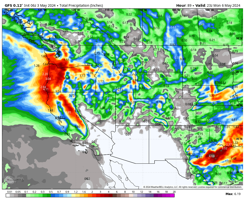
Below: Total moisture through Monday afternoon showing nearly 2 inches of water for Oregon, Northern Sierra Crest, and in the Wasatch and Teton ranges. Nearly every resort in the west will score some snow with this system with areas in orange and red highlighted (Precipitation). With the colder temps even a 1/2 of liquid could end up bringing 8-10 inches of low density snow.

While May is coming in deeper than a good portion of April we encourage you to support Powderchasers.
This is a bonus post for 23/24 and encourage all of you to please donate on our website or purchase the swag. The donations help us more so if you have taken advantage of chasing powder, or living vicariously through Powderchasers please contribute here. We survive on your help from the powder community. Donate: https://powderchasers.com/pages/donate-to-powderchasers
Swag is available here with a special sale on all the new tee shirts. https://powderchasers.com/collections/frontpage

Powderchaser Steve @powderchasersteve on Instagram


