Merry Christmas! We wish the snowpack across the west was a bit more merry than it’s currently looking. Below is the NRCS snow water equivalent percentage of normal station plot from December 23rd… unfortunately, lots of orange and red.

A storm rolled through over the weekend and dropped 6-10" in the Cottonwoods in Utah (11" at Brighton), 7" at Big Sky, 8" at Targhee, and 5-10" across Colorado (Aspen, Beaver Creek, Vail) (22" at Steamboat as of late Sunday). Orographic snow showers are really cranking at the summit of Steamboat as of Sunday evening and Monday will be deep. Alyeska in Alaska wrapped up Saturday with 13 inches (Cold to warm). Our chases have taken us from Wolf Creek Saturday (10-14 inches) to Beaver Creek Sunday (11 inches) and currently Steamboat Monday (15-20)
Below: Full on Nuking powder at Steamboat as of Sunday night! It has been snowing since Saturday afternoon pretty much non stop.

A series of minor but warm storms will roll through the Pacific Northwest early this week through Wednesday. After that, focus shifts to California: one storm on Wednesday afternoon and a more major system on Friday night. These storms are unlikely to bring major accumulations to Utah or Colorado.
In the short term, moisture will swing from Oregon up north into Washington. Snow levels will be extremely variable through when the precipitation ends on Tuesday morning, getting up to 4,500 feet at Baker and as high as 7,500 feet down south at Bachelor.
One exception is cooler air coming in from the eastern interior near Stevens Pass and the I-90 corridor. Colder temps for Stevens will likely provide mainly snow for all elevations peaking late Monday to Tuesday. Freezing rain is possible as you approach the summit of the pass. Baker is also a bit cooler and has nearly 1.5 inches of moisture aimed at them through Tuesday (Possibly decent snow totals at the summit).
Mission Ridge also stands a chance of some powder into Tuesday as well as the areas north to Twisp. Rain might overtake the cooler temps near Snoqualmie Pass on Tuesday while we think mainly wet snow will be falling near Stevens. Whistler will likely score some big numbers at mid mountain or the summit from this storm.
By the time things are wrapped up on Tuesday, most resorts are looking at 4-8” of wet snow with some rain and sleet mixed in throughout; not ideal conditions for skiing. Crystal will likely be the best skiing due to higher elevation and thus more snow at lower densities (Less moisture).
An unorganized system moves into the PNW on Tuesday afternoon and should bring a few more inches. Overall, not a great week for chasing in the PNW. Below is the 850mb temperature anomaly during the event early this week. Notice the warm winds from the south:

Selkirk Powder Guides is in their 21st year of Cat Skiing situated in northern Idaho. They offer advanced and entry level Avalanche Courses and fantastic backcountry skiing. They expanded their terrain by 6,000 acres this season (All new terrain). Please check out Selkirk Powder Here. They often stay in the colder sector of these warm fronts. They still have seats available.
Next storm for the Sierra
Focus shifts south on Wednesday afternoon as a minor system moves onshore in California. This storm should be wrapped up by Thursday night and bring 2-6” for Tahoe with snow levels around 7,000 feet. There is a lot of uncertainty with this system and the models are all still in disagreement about totals. There’s still a ton of time for these numbers to change, but chances are this won’t be anything more than a nice refresh for the snow surface for Tahoe. Below is the multi-model blend for totals from this first system:

The wildcard second storm approaches the Sierra Nevada on Friday afternoon. Some models have this storm dropping 5 inches and some have it dropping 20+ inches. As of right now, 6-12 inches looks realistic, although we are optimistic in today’s model trends and think this number could nudge a little higher. However, with the high volatility in the models, don’t get your hopes up for this storm.

The second California storm will bring a bit of moisture to Utah and Colorado this weekend, although this push of moisture will only bring a few inches and will not be a major system.
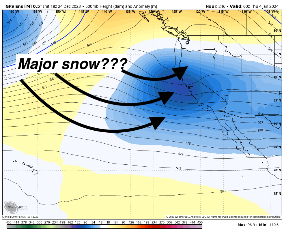
Looking ahead, above-average storminess in California will linger into 2024, with elevated odds of something potentially big brewing around the end of the first week of January. Something around this date is likely, although the exact timing and how much snow it might drop remains a mystery. See below the ensembles hinting at stormy conditions to start 2024, especially for California, Utah, and Colorado. This could potentially bring a major pattern shift for January, time will tell

Help us out!
If you want to chase powder with Powderchasers sign up for the concierge package for the deepest resorts to chase to and 1:1 custom forecasting with our staff. Also, if you have read this far, please donate for the holidays to continue receiving these free forecasts. We appreciate the community support. You won't regret chasing with our custom forecasts.
Follow us on Instagram and Facebook @powderchasers


