SUMMARY:
For chasing powder, requests from first responders and community leaders to communicate that they do not want a lot of people coming to town and definitely don’t want to deal with potential snow-related injuries when their focus should be on COVID-19. There is not yet a government-mandated travel restriction, but please consider what I just wrote before heading off to chase. At the very least, please be extra responsible and cautious so that you’re safe and do not cause a burden to healthcare workers. I do not suggest this means to not consider some outdoor activities but just use extra precaution and good common sense. Also, stay inside if you feel sick! I am a proponent for outdoor activities if you are healthy just for your sanity or mental health. I am not in favor of closing our outdoor recreating (Biking, Skiing) Backcountry but use common sense and follow social distancing. We are all in this for the long term with the outdoors perhaps being the only hope for keeping our sanity. This Forecast will address outdoor activities. For Backcountry travel (Hiking or skiing), please have the proper equipment and knowledge before venturing out. For some of us this might be walking, running, snowshoeing, or cross country skiing.
FORECAST:
Light moisture is focussing on the Southern Sierra Monday morning that will drag some snow into Utah (Brian Head) and eventually into Colorado late Monday night. Some light moisture is making it's way into the Northern Wasatch of Utah additionally. Radar is light in most areas with the exception of Southern Utah where moderate snow is falling. Heavier snow will be falling in all of these areas by midweek.
Below: Here is a look at the current Snow Water Equivalent YTD for the Sierra. The Tahoe Basin was sitting at 45% just 10 days ago. A nearly 20% jump in just a week's time is pretty significant.

The Pacific Northwest grabs a colder system that ramps up Monday late AM into Tuesday bringing a decent shot of moderate snow for most of the Cascades. The favored areas will be the extreme North near Mount Baker (8-12) and further south towards Mount Rainier to the Oregon border. Crystal will grab some moderate snowfall through Tuesday (5-10) with Stevens on the lower end of the spectrum. If resorts were open and I were in chase mode, aim for Baker (North) or White Pass (South). Cross Country, Snoshoe or hike if that is an option (Check restrictions and never venture into the backountry without the proper equipment and skills).
Colder air from the PNW sinks south over the Sierra Tuesday into Wednesday morning bringing another good round of snowfall for the Tahoe Region. Models peak intensity mid-morning Tuesday into Wednesday morning. Expect 9-12 inches of snow favoring the northern and central ranges (Decent quality).
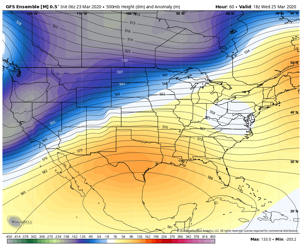
Below: Cold air is focussed from the PNW to the Sierra and the northern Rockies this week. Cooler air moves into the Wasatch and Tetons midweek albeit still keeping snow levels around 5800 feet. Temps will be very warm in the Tetons and Wasatch initially this week before slowly cooling.

This cold front weakens somewhat as it drags over much of the Intermountain West midweek. The Tetons will see 3-6 inches of dense snow Monday night into Tuesday morning (Rain in the Valley initially) with a cooling trend (Last few inches might be of decent quality above 7000 feet). Light snow continues in the Tetons through Midweek with a cooling trend.
The Wasatch slowly evolves from very warm temperatures early this week with a weakened cold front that is due late Tuesday night. This cooler air is likely to stay north of Salt Lake through much of Wednesday before slowly sagging south over the southern and central Wasatch (Park City, Snowbird, Alta, Solitude, Brighton) sometime late Wednesday into Thursday. The models focus modest snowfall Wasatch range Wednesday (Heavier north of I-80). Heavier snow and cooler temps are likely Wednesday PM into Thursday. It is possible that 12-20 inches fall above 8,000 feet at many locations by Thursday morning (Combined Tuesday night to Thursday). The peak snowfall is likely Wednesday into Thursday for the Central and Southern Wasatch with perhaps higher amounts in the North (Logan, Ogden Mountains) Tuesday-Wednesday.
Snow showers in Colorado this week will increase towards the northern border of Wyoming Late Wednesday to Thursday (Rabbit Ears Pass is a wildcard). A significant storm is due for the Front Range in the extended.
EXTENDED
The models currently show yet another strong system for the Front Range of Colorado for next weekend. It's possible that we see a repeat of the storm that recently nailed Boulder County and areas towards Rocky Mountain National Park (Closed).
Below: Ensembles bring the low pressure over southern Colorado Saturday morning pushing moisture north into the Front Range.

Below: Its too far out to predict with accuracy on an operational model, but current data is showing the Metro areas of Denver/Boulder/Weld Counties getting nailed with a deep storm Friday night into the weekend. The mountains further west will also see snowfall albeit lighter amounts West of the Divide. This could all change so stay tuned to the Chase Powder Forecast. Keep your snow tires on!

Stay home if you feel sick. The scary thing is that symptoms don't specify if you are a carrier of COVID. Remain at home if you can, but if mental health is important as it is to most of us reading this post, enjoy the outdoors practicing social distancing. I visited the Sand Dunes National Park early Sunday followed by some mountain biking in Pueblo that afternoon. Many folks were outside enjoying the outdoors.
Below: My early AM ascent of some of the Dunes in the National Park (Free entry) and not crowded. Photo: Powderchaser Steve

Enjoy the outdoors everyone! We will be skiing resorts again next season! Rules on lifts, numbers on Trams or Gondolas are all likely to change (The Ski Industry is going to change at least for the midterm).
Powderchaser Steve


