SUMMARY:
After studying the models extensively this morning, there is no perfect chase. The Sierra storm is delayed (That could be a good thing) with winds gusting over 100 MPH at the summits. Most moisture falls during Wednesday with the strong winds but Thursday could offer some prospects. The Rockies look semi chaseable from central Idaho (North of Sun Valley-Stanley- Northern Sawtooth backcountry) through to southern Montana. The Tetons are too warm initially but go into a deep freeze for Friday (Light to moderate snow). Colorado gets teased all weekend with a chance of something greater than 5 inches on Sunday. It's all Ho Hum initially but I think someone may score in the long run.
Snow is just starting to fall in the Sierra (Delayed by 3-4 hours). Radar is filling in over Truckee currently with snow falling a bit earlier over Interstate 80 near Donner Pass.
Below: 5 AM Pacific - moisture approaching the Sierra from the west.

Winds are going to crank this morning in the Sierra (90-95 summits). The Time Heights I pulled from the University of Utah show that it's possible some decrease in winds may happen from 10 AM to 1 PM so it's possible that lifts might spin that are closed early this morning. It's a big IF since winds appear to increase again by early afternoon before decreasing this evening. Aim for resorts that are less wind prone to issues. It's a warm storm initially so most of the snow today (8-13 inches) will be above 7000 feet. Much less snow will fall at the bases. Temps will cool tonight over the Sierra with another 4-6 inches of snow (Base to mid elevations). The southern Sierra grabs lower temps at Mammoth due to a higher elevation, however, moisture may be slightly limited compared to the north (Still respectable amounts). In looking at the models, I suspect that Kirkwood comes up a winner but its more speculation on my part versus science. Thursday may offer some decent conditions if we get lucky and the slightly better densities tonight deliver at least 6 inches (It could happen). Another shot of light or moderate snow will happen late Thursday into Friday (2-6) adding to the prospects of another decent day for terrain openings on Friday. If you missed Thursday aim for Friday.
In the Rockies, the primary focus is from central Idaho (North of Sun Valley) perhaps near Hailey extending east towards Montana. Southern Montana resorts are a wildcard with unfavorable wind direction (NE) but good moisture overhead on Thursday. The Good: Pretty confident on moderate snow for Big Sky, Bridger, Red Lodge Mountain Thursday/Friday. The Bad: Limited amounts of overnight snow (2-5) and another 3-6 during the day Thursday. It's not going to produce any epic amounts in a short period, nor much of an overnight dump. Temps are very warm Wednesday and colder Thursday (Increasing quality on a firm surface). Wildcard: There are some differences in the GFS (optimist) and the Euro (Pessimist) with a chance that some areas end up with 10 inches by 4 PM Thursday and another 2-5 for Friday. That is the top end! Winds from the East are not optimal so I am not sure what that will do to the snow totals.
Below: University of Utah SREF Plumes for Big Sky showing steady light snow from late Wednesday to early Friday. 29/00Z is the last chair on Thursday with a mean average between 6-9 inches.

The Tetons get teased Thursday with warm temps (35-38 bases) before a cold front drops snow to the Valley floor on Friday. Expect storm totals (Thursday and Friday) to be in the 3-6 inch range (Friday is the better day but not worth a long term chase). Some additional snow may fall in the Tetons Friday night bringing storm totals in the 6-8 inch range at the summits (1-3 at the bases). The Wasatch will also be in that 3-6 inch range from Thursday to Friday (Friday is the better day). Warm temps will keep snow above 8,000 feet initially falling to 6500 feet by Friday or Saturday. It's possible the upper Cottonwoods see slightly higher amounts.
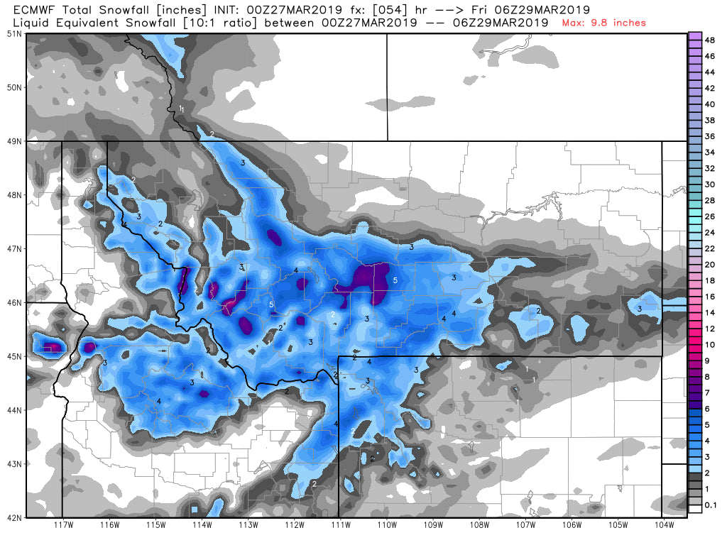
Below: The pessimistic (Usually the most accurate) Euro showing 3-6 inches from the Tetons to southern Montana by late Thursday night. I suspect higher amounts might fall in some areas of Montana but can't pinpoint it currently. This map is not very exciting.

In Colorado NW flow initially goes Northerly late in the weekend. Light snow will be falling from Friday to Sunday. The best period of snowfall appears to be late Saturday to Sunday where some isolated locations in Summit County or near the Front Range pick up another 3-5 inches.
EXTENDED:
There will be high pressure early next week for much of the west. Models show a warm system may begin to impact the Sierra as early as Monday night that spreads north over the Cascades, Idaho and eventually the Rockies by Tuesday or Wednesday. Areas of Wyoming and Utah may be in the path of additional snowfall with warm temperatures on the grids keeping any prospects at upper elevations only.
Ensembles show possible systems along the coast in the April 5th timeframe that look to push inland with decent moisture around April 9th. There may be a stormy period during the April 9-12 period.
ANNOUNCEMENT:
Snoshark just provided us a $39 discounted rate for Powderchasers (Normally $59) for the best snow removal tool for the deep (Fast). Use this link to access this promotion https://snoshark.com/discount/PCSPRING. Enter PCSPRING in the promotion box for an addItional $10 off. Total should come up at $39.95.
Any concierge sign ups now for mid leval or greater get full benefits for all of next season! Thats a good deal if chase and want custom forecasts.
https://powderchasers.com/concierge
Enjoy the powder everyone!
Powderchaser Steve


