Significant snowfall is falling in the Sierra Monday morning. This system is pushing north into the Wood River Valley (SV) and the Tetons in the short term. Significant snowfall will crush the 4 corners midweek. Further north, snow continues like a freight train (Slow and steady) with some areas picking up 2-3 feet.
This post is sponsored by Skis.com. Any purchases of $200 or more earn you a free powderchasers shirt (Just send us an email).

Mammoth Mountain unofficially (Telemetry) has picked up 27 inches (2 day total) as of Monday morning. Further north the Palisades telemetry is showing 8 inches overnight with temperatures cooling. SugarBowl has around 14 inches. Kirkwood reported 19 inches! Quality will be dense, however with temps cooling the toppings will likely be very good as it continues to snow on Monday morning. Winds will hopefully decrease my late AM Monday (Don't expect everything to open).
Below: Moisture is peaking on Monday for the Sierra favoring the Tahoe Basin. The southern Sierra will likely see less on Monday, but scored healthy totals Sunday-Sunday night. You could chase to any resort around the lake on Monday and grab double digits, however higher elevations might see the best quality. Lake level snow will be falling on Monday with the cool down. Winds will decrease at some point Monday morning. Wind gusts on Sunday night hit 120 MPH at 8700 feet at Palisades! Lets see who spins lifts?

Moisture streaming north will impact Sun Valley and the Tetons on Monday. Temps are on the warm side with bases in the low 30s and upper peaks likely to stay in the mid 20s. Medium to dense snow is likely for SV (5-9) and for the Tetons (JHMR favored under S SW flow). The summit of JHMR will likely see 7-9 inches by later Monday and decrease by evening. In my previous forecasts I have mentioned Sun Valley several times. SV picked up 15 inches in the previous few days (Southerly winds). This storm is no exception with an additional 10-20 inches expected by midweek! You can storm ski on Monday.
Chases: Sierra Monday/Tuesday (New openings). Northern Rockies including Sun Valley and JHMR for Monday for moderate powder a bit on the dense side. With the colder temps in the Sierra Monday the quality might be very good. above 8K.
Extended
The highlights come midweek. Strong moisture pushes into the 4 corners. Significant snow will be falling late Tuesday to Wednesday for the San Juan Range. Very significant totals will be found in southern Nevada (Lee Canyon), northern Arizona (AZB), southern Utah and the southern San Juan Range in Colorado. Several feet will be the end result by late Wednesday. New Mexico is currently a wildcard.
Below: Total snowfall graph for Red Mountain Pass in Colorado peaking near midweek (February 7) for 10-20 inches or more.

Below: JHMR moisture graph in 6 hour increments beginning Monday February 5 to February 12 (7 days of moisture peaking Monday and midweek Feb 8). You cans see the snow to liquid ratio increasing to 15:1 (Grey line) by Wednesday with cooling (Better quality). Earlier in the week we are only at 10:1 at mid elevations.

At the same time that the 4 corners gets crushed, additional moisture will push north into Sun Valley and the Tetons. Wednesday morning could be deep in SV, while the Tetons continue to see a steady chug of moderate events (Sum totals will be 10-20 inches over the next 3-4 days). Southern Montana will stay on the moderate side (5-9). Midweek will offer chases to the 4 corners or further north to Idaho or Wyoming.
Below: Total snowfall for Idaho and Wyoming by Thursday will be healthy, especially in the Wood River Valley near SV. The Tetons will slowly build totals all week.

The Wasatch gets teased early week (Consistent light or moderate events) and peaks on Wednesday/Thursday. Storm totals from Monday to Thursday will be healthy, however any single double digit dump in 12 hours might hold off until mid week when the action peaks Wednesday night.
Below: University of Utah graph (GFS only) for Alta showing a reasonable solution of several small waves of snow (Dense initially) from Monday to early Wednesday followed by a bigger surge into Thursday and cooler temps.

Below: Arizona will see a healthy dose of snowfall late Tuesday night through Wednesday.

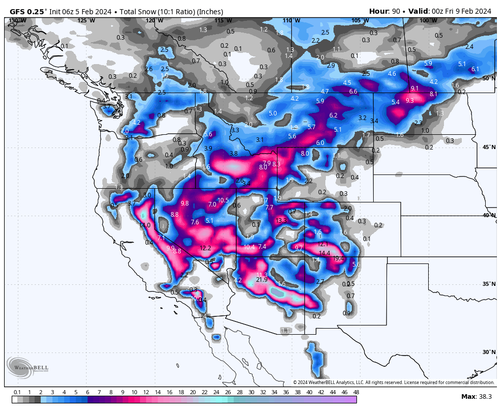
Below: Total snowfall through Thursday afternoon at 10:1 showing highlights in the Sierra (Short term), Southern Nevada (Vegas mountains), Arizona, Southern Colorado (New Mexico wildcard). Decent totals push north into the Wood River Valley Idaho with the Tetons in the flow all week (Steady chug of light to moderate events peaking Monday and Wednesday). The Wasatch teases early week with a peak by Thursday morning. I have less confidence in northern Colorado but that could change.

You have many options this week. You might get skunked in the Sierra depending on what opens on Monday. Quality will be decent on top of a wind and warm layer. The 4 corners will be deep by midweek. Consider chases to Sun Valley or the Tetons. The Wasatch might deliver good weekly totals peaking Wednesday night.
Help us out!
If you want to chase powder with Powderchasers sign up for the concierge package for the deepest resorts to chase to and 1:1 custom forecasting with our staff. Also, if you have read this far, please donate to continue receiving these free forecasts. We appreciate the community support. You won't regret chasing with our custom forecasts. We have new swag on the Powderchasers storefront and all larger donations include it at no charge.
Enjoy the powder, everyone! Remember, your deepest resort is not always the best chase. See you in the first chair somewhere on Monday.
Enjoy the powder, everyone!
Powderchaser Steve @powderchasersteve on Instagram


