
There is a train of systems nearly every 24-48 hours that are impacting the western US currently. This should continue in earnest at least until early next week with unfortunate warm fronts followed by shallow cold fronts on the back end. This is the classic signature of an atmospheric river (Warmer air and lots of moisture). As of Tuesday evening, we have seen 17 inches at Palisades at 8K, and 19 inches at lower elevations of Mammoth (Unverified). The summit of Mammoth is likely much deeper. Temps started out very warm on Tuesday but have cooled in the Sierra with most locations in the lower 20s at higher elevations. The bulk of moisture for the Sierra has passed Tuesday evening with the exception of some heavier snow bands for the southern Sierra (Mammoth or south). Snow quality will be dense, especially below 9,000 feet. Higher elevations may actually ride pretty well so pick your resorts wisely. Winds will also decrease so it's likely some lifts that were closed Tuesday open on Wednesday. Aim for higher elevation resorts on Wednesday. Mammoth might be a good bet especially if the Summit opens with lower-density snow.
Announcement!
Powderchasers and our forecast staff are supported by our readership, so if you have not donated, please do so here or join our powder concierge program where we provide 1:1 trip planning for chasing, last-minute custom forecasts, and the best pow day of your life. Support our sponsors and be sure to follow our Instagram and Facebook page @powderchasers.
The PNW is finally grabbing some cooler temps with good snowfall totals expected for the Oregon Cascades (Upper peaks) and most of the central mountains of Washington near Stevens Pass and I-90 (Cooler temps are noted with 5-12 additional inches). some areas in the Cascades have been closed for ice and rain for the last few days.
In the Rockies wet heavy snow in upper elevations of Sun Valley with rain and snow mixed changed to all rain in the early PM Tuesday. Conditions were marginal, to say the least. Similar conditions existed near Brundage (Low elevation rain). The Tetons were spared much rain and picked up around 8 inches at JHMR with temps ranging from the mid to upper 20s Tuesday morning dropping to the low 20s' at press time (Higher elevations). The base was 37 degrees at the lift opening (Likely some rain) with mid-mountain just around the freezing mark (4-5 inches). The upper aspects might have skied okay, with a creamy base and a bit of drier density from Tuesday afternoon. Light snow is likely through Wednesday morning but not much additional accumulation.
The Wasatch is on watch! Heavy snow is likely for the Cottonwoods above 8,000 feet with snow levels dropping to 5500 feet by Wednesday morning. Snow showers will continue for the morning commute but at a lower intensity. Peak snowfall will occur late Tuesday night into the pre-dawn hours of Wednesday. Models show 9-17 inches Tuesday night with an additional 3-5 possible (Lower density) after daybreak on Wednesday. Winds were a major factor on Tuesday with many areas not spinning upper lifts. Avalanche danger is rising with the dense snow. LLC will be closed on Wednesday morning for control work. In Park City outside my office, it is a mix of sleet, slushy rain-snow mix currently at 6500 feet. I don't expect any rain Tuesday night as temps cool through Wednesday. While it won't get downright cold there is still hope of some medium-density pow on top of the very dense snow that falls until midnight Tuesday. (Cooling will occur in Utah after midnight). Light to moderate low-density snow is likely for Wednesday for the Wasatch Range.
Below: Cooler air moves into Utah around midnight and reaches northern Colorado around daybreak Wednesday. Density will decrease as well as the winds.

The moisture heads south over the 4 corners which will provide some much-needed snow for Arizona and regions of the San Juan Range. Currently, the average snowpack in the Colorado southern mountains is 65% of normal. These next several storms will provide much-needed relief in the terms of water. While this storm is favoring southern and central Colorado with SW winds, the northern areas are grabbing favorable NW winds. NW flow will enhance totals near Rabbit Ears Pass, and the Flattops (Northern Colorado). Some models pump out 6-10 inches. Currently, it is snowing at the summit of Steamboat with some snow noted over Vail. It's possible these areas do better than originally forecasted. In the southern areas of Colorado, the main highlights will likely be from Crested Butte and south to Silverton, Telluride, and Purgatory. Wolf Creek will score but some discrepancies exist in the models, and while they will score decent snow, higher amounts might land further west or north. Expect peak snowfall in Colorado to be from late Tuesday in the northern mountains to after midnight through Wednesday in the southern and central zones. Totals in the southern or central regions might exceed 12-16 inches by the last chair Wednesday at the upper peaks. Snow quality will be dense with colder air arriving behind the main push of moisture (Better quality on the backside). Aspen is a wildcard.
Below: Steamboat scored some decent numbers at the summit as of Wednesday morning- Looks dense. Crested Butte appears to have similar amounts.

The extended forecast looks very deep with another parade of storms headed toward the Sierra and PNW. The next system arrives late Thursday night into Friday with another due for the weekend into the New Year. In looking at temps they will likely follow similar signatures to the current system (7-8000 foot snow levels lowering with weak cold fronts). Models pump out another 3-4 feet by late this weekend. These systems will favor similar regions (Sierra, PNW, Idaho, and the 4 corners). There appears to be a cut-off low forming over the Pacific that might park itself for several days over the west. If this happens we could see additional feet of snow next week, especially for the Sierra.
Below: Storm #2 entering the Sierra by late this week and weekend (Map is for late Saturday).

Below: Storm #2 is dropping into the 4 corners late this weekend into early Monday with storm #3 on its heels noted in the Pacific near Oregon.

Below: Moisture might continue for the west into midweek January 4th which appears to be a cut-off low that parks itself over the far west (Slow mover)
 \\
\\
Below: That system is still noted late next week parked over the west on January 6th with snow continuing

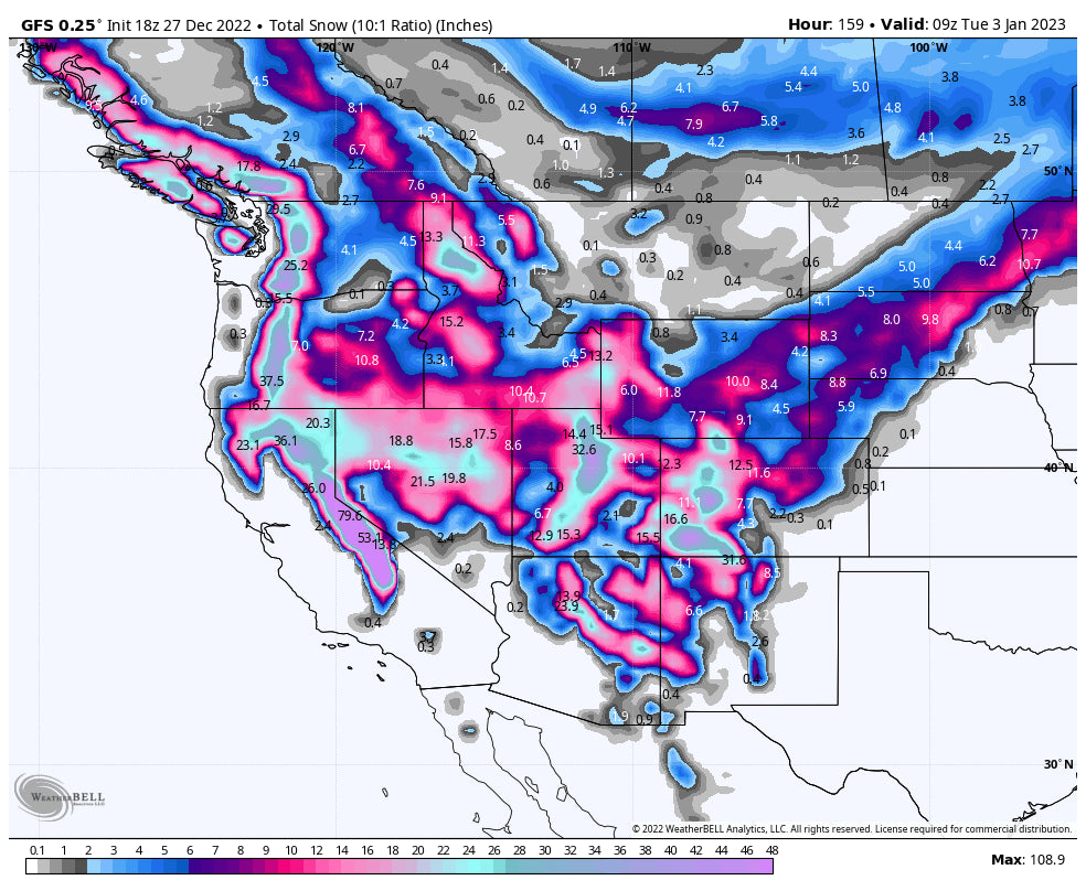
Below: 7-day snowfall potential for upper elevations of the west through next Tuesday. Much lower amounts are likely at the bases. Some areas could exceed 60-90 inches, or perhaps more depending on next week's low and slow movement.

You can follow my chases and travel adventure photography on Instagram @powderchasersteve
Good luck in finding that cold air, or upper elevation powder. We will update this forecast on Thursday or Friday.
Powderchaser Steve


