SUMMARY
The weather for the west will be wild with very deep moisture plumes every 24-48 hours favoring the Sierra and headed east over the Rockies. Temps will warm significantly with each deep Atmospheric River event followed by cold fronts. The PNW may see a cold storm Thursday night. There is also hope in the Rockies
FORECAST:
This is not an easy forecast with so much going on over much of the west currently. I can definitely tell you who will see the highest snow totals but in some cases. you might want to run in the other direction. The pattern stays similar to the past storms however this weekend will be even warmer with snow levels rising to above 9000 feet in the Sierra and 8,000 feet in the Rockies. A cold front late this weekend for the Sierra and due for the Rockies by Sunday night will give us hope for some better-quality snow. The big question is \what will open\", \"Will there be road closures\" and a significant avalanche danger with the high moisture content of the weekend storm. Your deepest resort will not be the best.
Before I get into the Forecast, here are a few highlights from the past few days.
Brighton- 37 inches
Solitude-33 inches
Park City-25 inches
Powder Mountain-20
Selkirk Powder Guides (Our Powder Cat Sponsor)- 19 inches
Beaver-15 inches
Steamboat-18 inches- (NW wind direction noted on the models for the northern mountains)
Silverton-20 inches
Wolf Creek: 21 inches
Telluride-14 inches
Purgatory-20 inches
And to top off the surprise win for Thursday morning was 15 inches at Grand Targhee mainly since late Wednesday and overnight with what I call the \"Targhee cloud\". The winds were from the N, NW which is ideal for them. I believe the town of Driggs only picked up a few inches so those that made it up Thursday were greeted with deep freshies. The reports from Utah, Wyoming, and Colorado on Thursday all were very positive.
Below: Powderchaser Steve hiking Baldy on Thursday morning at the Bird.

Announcement!
Powderchasers and our forecast staff are supported by our readership, so if you have not donated, please do so here or join our powder concierge program where we provide 1:1 trip planning for chasing, last-minute custom forecasts, and the best pow day of your life. Support our sponsors and be sure to follow our Instagram and Facebook page @powderchasers.
Below: Today: Prior to opening the resort on Thursday a significant slide from grooming a Cat Road at the top of Mineral Basin broke loose with the cat taking a free ride in a very large debris pile 2-300 yards below. Fortunately, there were no injuries. This reminds us to respect closures and the real risks of avalanches. high-five your ski patrol and Cat operators. Snowbird Patrol did an amazing job during the last storm and managed to open nearly all of its terrain, and even Mineral both Wednesday and today! Photo @powderchasersteve via Instagram

It is going to be difficult to find cold powder in the next several days. There are a few exceptions. The PNW has snow levels low enough for all snow at the bases from Thursday night into Friday. I would aim for White Pass, Crystal, Mission Ridge (Southerly flow), and perhaps Stevens with Baker as a wildcard. Oregon will see warmer temps with the models showing higher totals (9-14) for Mt Bachelor Friday morning. Warmer temps move from south to north through Oregon and Washington by mid-morning or early afternoon Friday (Could be mixed precipitation over Snoqualmie Pass by PM). I would chase this storm if I were in the PNW. Some areas will be decent early Friday but warming occurs late. Friday update: Stevens Pass, Baker, and Mission Ridge reporting 7-9 inches overnight. Oregon resorts are likely to report decent numbers once they come in.
In the Sierra, a very deep plume of moisture is noted on models from Friday morning to Sunday morning. Temps are warm on Friday with snow levels rising to 8500 or 9,000 feet! Temps are cool Saturday (7,000 feet) and will further get colder by late Saturday/Sunday where lake-level snow is likely. Unfortunately, I don't see significant moisture with the colder air but conditions, if ski areas are open Sunday, might actually ride decently on top of the quagmire of stuff that falls beforehand. Bottom Line: Not a storm I would chase but you might get lucky, especially Sunday. Cooling next week.
Below: Cooling noted for the Sierra by late Saturday into Sunday (Map- 10K feet in celsius). It is still warm over the central Rockies but cooling in the PNW and further north.

Below: Total moisture for Northern California through Sunday morning is truly fantastic for water but will become a chaser's nightmare if you want powder and lifts to be spinning. I am not sure I have seen this much precipitation in such a short period before. Don't expect much to be open.

For the Rockies, snow will be falling as early as Friday morning for the Wasatch Range with perhaps some 7-9 inch totals by the last chair, especially in the Cottonwoods or higher elevations. Westerly flow could provide some decent amounts north towards Ogden, as well as the Park City area with lower amounts by late Thursday (3-6). Warming occurs late Friday to Saturday decreasing quality. Bottom line: Last chance to see some colder snow as the next system warms by late Friday. Might be worth watching.
Summary of the weekend into early next week for the Rockies
I am only covering highlighted areas of who might see the most snow and conditions that could be chase worthy. Warming occurs late Friday for the Rockies with snow levels rising above 7500 or even 8,000 feet by Saturday in the Wasatch. Significant accumulations are likely to continue at upper elevations in Utah late Friday to Saturday morning (15-25). Rain will be falling at lower elevation resorts. It's a bit cooler further north in Wyoming with moderate snow likely for late Friday/Saturday (6-12). In Colorado moisture arrives late Friday to Saturday with a warming trend (Surfy pow).
The best odds of finding deeper powder will once again be on the western corridor of I-70 from Aspen and south to Crested Butte, Silverton, and perhaps further south to Telluride (Wildcard, unfavorable wind direction) with models showing just moderate amounts for Wolf, and Purg. Of note, the models show heavy snow possible again for Steamboat during this period. Winds are not in a favorable direction (SW or S) so my optimism is less than the last storm where they veered NW. Also, lower elevation will not be your friend with this storm. This will be a dense storm initially.
Colder air arrives in the Rockies Sunday night through Monday. Rain at lower elevations will change to all snow, and quality will improve for Monday, especially for Utah and Colorado where NW flow on the backside of this storm can produce some decent totals. The cold front should reach Utah by late Sunday and Colorado by Monday morning. The models are unclear on how much snow falls after the cold air. It's likely that Utah scores some good quality pow (Guessing on moderate amounts) on the backside of this event. Colorado will see some decent snow totals Monday. This has the potential for several resorts to be reporting some decent quality powder and shows higher amounts in the San Juan Range. Bottom Line: Quality increase later Sunday or Monday but resorts might keep steeper terrain closed or will be digging out. Could still be a risky chase but the potential exists.
Below: Total moisture for the Rockies through Monday morning. Healthy totals for many areas favoring Utah/Wyoming, Colorado, and even Arizona (Snowbowl will see some snow with high snow levels). Upwards of 2- 4 inches for Utah, 1-2 inches in Colorado and Wyoming. The Sierra is off the charts!

EXTENDED:
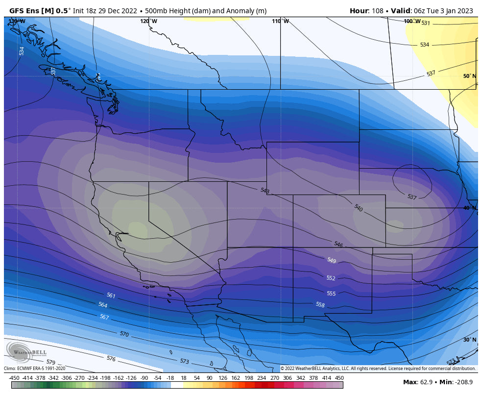
The trend for the beginning to the end of next week is for additional storms to enter the Sierra with a cooling trend. Snow levels will come down for the next storm in California on Tuesday (Moderate system) and are noted to warm slightly for a wetter system for next Thursday. We should not see the snow levels nearly as high next week. For the Rockies, it's not clear where the highest totals will land as moisture decays somewhat over the Sierra and moves east (Future post). Temps will be a bit cooler.
Please follow my Instagram feed at @powderchasersteve for the latest updates and chases.
This was not an easy forecast this evening with so many moving parts. This might be a storm to avoid in some areas (Pick the lower totals) and be aware of rapidly rising avalanche danger in the backcountry with upside-down snow conditions. We are still looking for sponsors to be highlighted on the website to support our forecasts. please email us directly from the website if you are interested in joining our powder community.
Powderchaser Steve


