
This has been a very active October with rare double digit dumps so early in the month. The western sections of British Columbia in Canada may nab another 3-5 feet at upper elevations this week. Alaska BackCountry Guides near Valdez has seen 30 inches in the past 7 days and is expecting 2-4 feet this week.
Announcement: Mountain Collective Pass rates go up tonight (Monday) at midnight. Here is the link to MC
Whistler nabbed 11 inches just above mid mountain to the summit, while Revelstoke grabbed similar totals inland. The next storm will be deeper and colder later this week/weekend.
Below: Revy snow cam was buried on Sunday morning (Roughly 30CM).

Below: Peak at Whistler Mountain is looking very winter like (6-12 inches in the past 36 hours) with much more to come.

Forecast Highlights
- Atmospheric River to slam into BC aiming south over the Cascades this weekend
- Cold air this weekend will bring snow levels to 3500 feet (PNW)
* First significant storm for areas of the Cascades
* Western Canada peaks could see 20-30inches of powder
* Alaska continues to get dumped on
ALASKA BACKCOUNTRY GUIDES, our long running sponsor still has a few seats open for epic Heli skiing in February and March. Mention Powderchasers and get a free concierge Package and swag bag.
Below: Total snowfall through Sunday night October 27th with over 80 CM for the higher coastal ranges of Canada. 30 plus CM for the interior regions and double digits for areas of the Cascades. Peak snowfall will be later this week into the weekend with a cold front. Whistler will nab 30-50 CM.
 Below: Colorado grabs a teaser storm moving in from the 4 corners on Thursday morning with snow levels above 10K feet. This will bring 2-7 inches to the summits of some ski areas primarily central and southern Colorado.

Weekend Storm
Below: Snowfall late this week from Friday October Friday to Sunday night October 26th The emphasis will be over Canada, PNW, trickling into many regions of Idaho, Montana, Tetons, and perhaps Colorado later this weekend.

Below: 4800 foot temps are well below freezing this weekend with a cold front over the PNW that will bring pass level snow to many locations (Snow level near 3000 feet).
 Below: Some expected snow totals will exceed 2 feet near Whistler, 12-16 inches for the northern Cascades (Mt Baker), and 5-10 inches for areas south in Washington. Winds from the SW favor the northern Cascades such as Mt Baker while areas south prefer W or NW winds. Interior BC will also do well with this storm with 12 plus inches at many locations.
Post Frontal westerly flow and colder air by Sunday could kick in some surprises near Stevens Pass later in the weekend. Oregon should also do well with this storm especially near Mt Bachelor (12 plus inches).

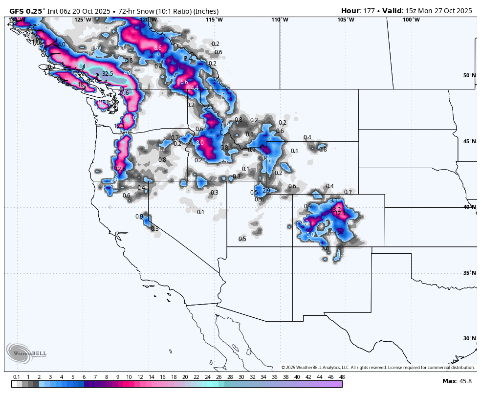
Below: 3 day snowfall ending Monday October 27th per the American GFS highlights the trajectory of this moisture and colder air. Aside from highlights in the PNW and Canada, we should see moderate totals in northern and central Idaho, Teton range, and perhaps the core of the Colorado resorts.
 Below: The European model is a bit more bullish for the Tetons and Wasatch. Some snowfall will also trickle south Into the Sierra (3 day snowfall ending Monday October 27). Central and southern Oregon are also highlighted here (10-20 inches).

Please support Powderchasers free powder forecasts with a donation here or join our concierge program while it is on sale through October.
Sponsor Alert Below! We need a few more sponsors.


