
Highlights
* Teaser storm for the Rockies midweek with light to moderate snowfall, especially in Colorado.
* Moderate New England Powder for central and southern regions being favored Tuesday/Wednesday
* Stronger storm for Canada, northern PNW, and Rockies for the weekend with double digits.
* Storms continuing in the northern tier of the PNW, Canada, and the Rockies next week
* Possible Ridge breaking down in the west towards December 14/15 (Too early to be confident), which could bring a return of snowfall to the Sierra.
Overall Synopsis: The West is stuck with another storm that is moisture-starved but could still deliver 3-7 inches in a few areas favored by upslope flow in Colorado. The last storm had W, NW flow and better energy to bring double digits to many ski areas. This storm shows a low weakening over the 4 corners and provides counterclockwise winds for western Colorado that will provide weak orographics for many mountain locations. The energy will provide 2-5 inches for many southern, central, and northern mountains of Colorado, with slightly higher totals possible on the eastern Divide, and even Wolf Creek Pass (Eastern side). New Mexico will be grabbing some snow also (Angel Fire or eastern influenced resorts are favored). Wolf Creek is a wildcard for 4-10 inches (Some models show a few highlights).
Utah and Wyoming are stuck with disorganized moisture bands and lighter totals. The Cottonwoods could sneak out 2-5 inches from Tuesday PM to Wednesday morning.
This is kinda a boring storm, that might overproduce in a few areas of Colorado. We will take everything Mother Nature can throw at us right now.
Below: Low pressure weakening and diving south over the 4-corners Tuesday/Wednesday. This will provide light snow to the Tetons and northern Utah, with perhaps some light to moderate totals as counterclockwise and easterly winds provide upslope flow to eastern Colorado and New Mexico.

Below: The European model seems to fill the gap of most models on this storm. You can see light or low-end moderate amounts for many ski areas in Colorado. The general trend is 3-7 inches (Better snow ratios than shown on this map) with a few pinks noted near Wolf Creek and the eastern areas (Chucara Ski Resort). Eldora and Angel Fire might benefit from upslope flow. Some higher totals are also showing up near Aspen, but I can't fully sign off on this yet.

Below: The cold air with this storm is also noted closer to the Front Range of Colorado (East side of the Divide), which will help with snow ratios and perhaps a few upsides.

Below: Total snowfall in the west with the midweek storm (Tuesday-Wednesday). Very weak energy is noted in most areas of the northern Rockies, with this short-term NAM model being the most bullish for southern Colorado (The Deterministic GFS and Euro show a bit less). Front Range Resorts in Colorado might do a bit better than the core of I-70. These low-energy storms can still overproduce in a few locations, but it's unlikely to be a blockbuster.

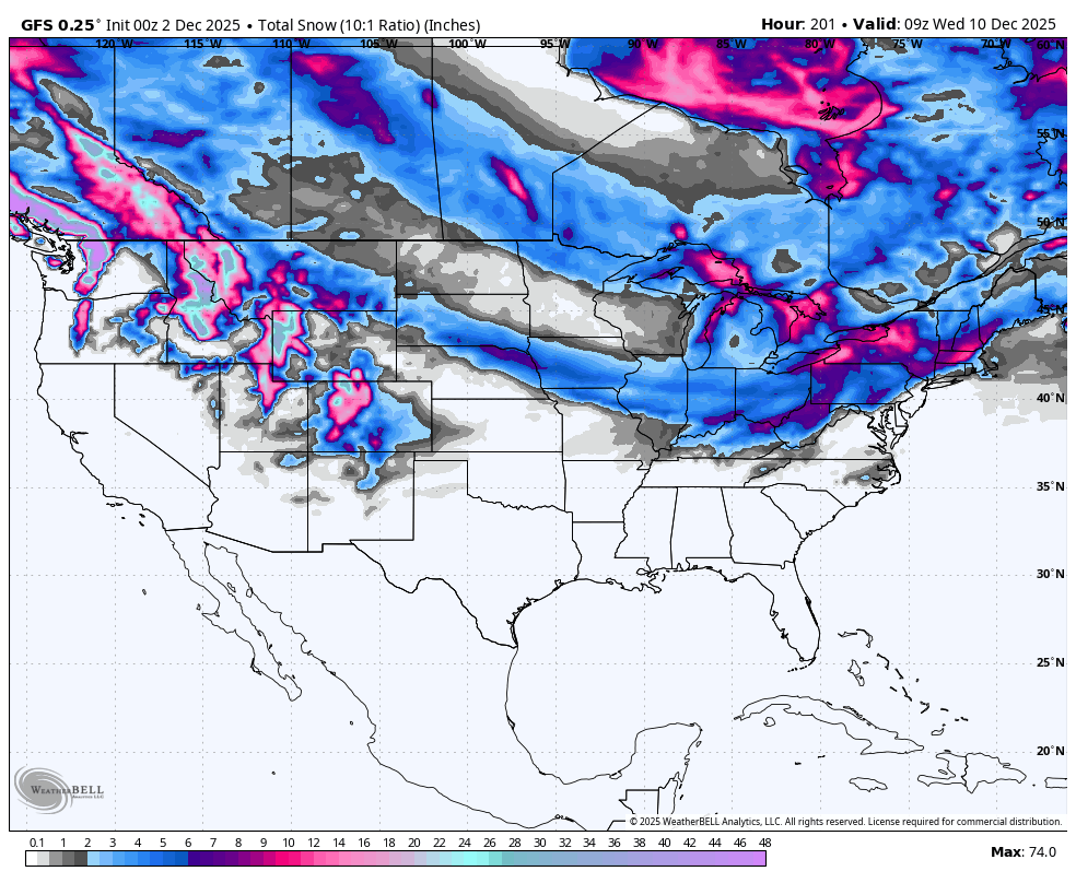
New England totals have decreased somewhat, with the emphasis still on southern resorts in Vermont, and most of the core of the I-93 corridor in New Hampshire. This will extend into central Maine (Sunday River). Good timing for Tuesday night to Wednesday morning powder (1st tracks Wednesday). Northern areas of New England will grab 3-7 inches, with a few southern and central resorts in New Hampshire in the 5-10 inch range.

The extended looks 100% better for some areas of the west. Keep reading.
Extended POW
The general trend is for the storm door to open up with good NW flow this weekend, sending storms from Canada into the Rockies. This will likely impact the northern PNW (Washington). Unfortunately, the signal for Oregon and areas of the Sierra and southern Rockies is less prominent initially.
Below: Low pressure seems dominant this weekend, again mid next week (PNW, Canada, north/central Rockies), and eventually dipping south hopefully by December 15th (End of this loop). You can see the NW Flow initially with these storms (Bars on graph) and eventually perhaps SW over the Sierra at the end of the loop (December 15). The Midwest and East Coast also stay active. The ridge parked over California hopefully buckles at the end of this loop.

Below: 48-hour snowfall totals with a storm later this week (Friday-Saturday) in the west. This seems like a good, healthy storm that hopefully holds together. Unfortunately, a high-pressure ridge keeps the precipitation focused on the northern tier of the PNW and the Rockies.

Below: Cold air this weekend is confined to the northern PNW, Canada, Wyoming, the Northern tip of Utah, and Colorado. The highest snow totals might land in these areas where the snow ratios are a bit higher.

Below: 24-hour moving snowfall map showing 2 storms from this weekend to mid next week. The emphasis is on a northerly track; however, as noted (Upper right), the mid next week storm might dig a bit further south into Oregon. These are 24-hour snow totals with both systems (This weekend and mid next week). The storm door might stay open, and hopefully drop further south towards the end of next week.

Forecaster: Powderchaser Steve @powderchasersteve
Please support your love of powder and our forecasts with a donation here, or join our concierge program.


