It's a fairly quiet Sunday morning with snow showers showing up on the models for extreme northern Colorado early this week. Snow will increase at the summits by Tuesday afternoon in southern Wyoming and North/Central Colorado. Some sneak-up deeper powder is possible Wednesday in Colorado.
Announcement: One of the largest pre season music, film, and snow festivals is taking place in Salt Lake City this Friday/Saturday. Powderchasers is happy to be a part of this event. Several vendors, TGR movie, Rail Jam, and ski pros will be at this event. You can purchase your tickets here. Please join us at Shredfest Friday and Saturday. Powderchasers Mascot Noodle will be at the event.
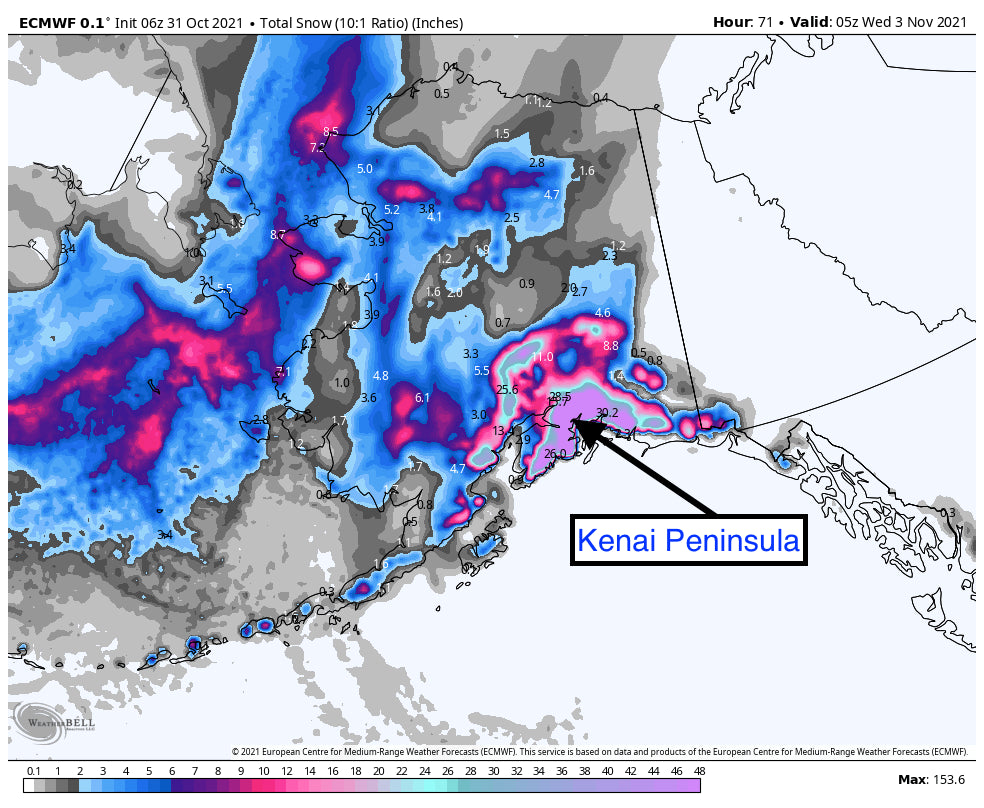
Significant rainfall has hit Alaska with 4-6 inches of moisture in the past few days on the Kenai Peninsula. The models pump another round of very heavy moisture into next week for south/central Alaska with an Atmospheric River aimed at the Kenai Peninsula and the Chugach range. Taking a quick look at the temps for Alyeska Resort it's just at the freezing mark at mid-mountain Sunday morning with low 40s at the base.
Below: Mid Mountain Temps at Alyeska Resort is just at freezing-Impressive precipitation of greater than 4 inches has fallen in the past 24 hours Sigifcant high elevation snow is likely this week. Rain at the bases with a cooling trend mid-next week. it's possible the summit of Alyeska nabbed very deep snow in the past 24-36 hours with temps that remained below freezing. 4 inches of precipitation might equal 30 plus inches as the summit. More precipitation is on the way for Alaska this week which will be significant.

Below: Total snowfall this week for south/central Alaska is very impressive at the summits. Much of this snow will be falling over the Kenai Peninsula outside Anchorage (Summits will score nicely).

Highlights of this forecast will include a weak trough to hit Colorado this week. Temps are warm with snow levels in the 9-10K range until Tuesday night under SW flow. A slight decrease in snow levels and increasing moisture will likely bring 5-10 inches to the northern mountains by Wednesday afternoon (Above 8500 feet). While the system is not moist, orographics (cooler air forcing lift over the mountains-Downslope) it's possible we see some sneak up higher amounts over the peaks along or north of I-70 (Including Summit County). The American Model is still more pessimistic (4-9 inches) with the European bringing in in higher amounts (9-14). Snow will be on the denser side.
Bottom Line: Weak trough over northern Colorado early this week with snow showers above 9,000 feet. Stronger forcing, cooler air NW flow Tuesday-Wednesday with an uptick in snow intensity. All of the northern Colorado Mountains and areas just south of I-70 stand a chance for a sneak-up powder day by PM Wednesday. This includes Steamboat (European model highlights), Rocky Mountain National Park (Some northerly wind component could help them), Vail Pass (NW flow surprises), and Breckenridge (High elevation benefits).
Below: The American Model being the most pessimistic (Usually that's not the case) is showing early next week's snow totals at upper elevations in the 5-9 inch range. Some highlights include RMNP, Winter Park, and perhaps Steamboat. The European Models show higher amounts and shift more moisture into Steamboat, Summit, and Vail Pass. It's possible decent amounts build up slowly (No intense period) through Wednesday afternoon (6-14).

Extended Forecast:
Much colder temps plunge into the Pacific Northwest late next week. Snowfall should increase over the Cascades of Oregon and Washington, northern Idaho, and slowly spread over the northern Rockies albeit weakening somewhat. This will be addressed in a later forecast. This might be a decent storm for the Cascades.
Below: Coldest temps of the season move into the PNW and BC late next week or weekend. Snowfall is likely in the PNW, BC, and areas of the northern Rockies. Image: Courtesy of WeatherBell 10K feet temps in C.

Here is a pick from southern Utah of Powderchaser Steve riding last week, taking advantage of some warm temps near Bryce Canyon.
@powderchasersteve via Instagram

Enjoy the new powder this week if you can stay at higher elevations. See you at Shredfest this week!
Powderchaser Steve


