SUMMARY
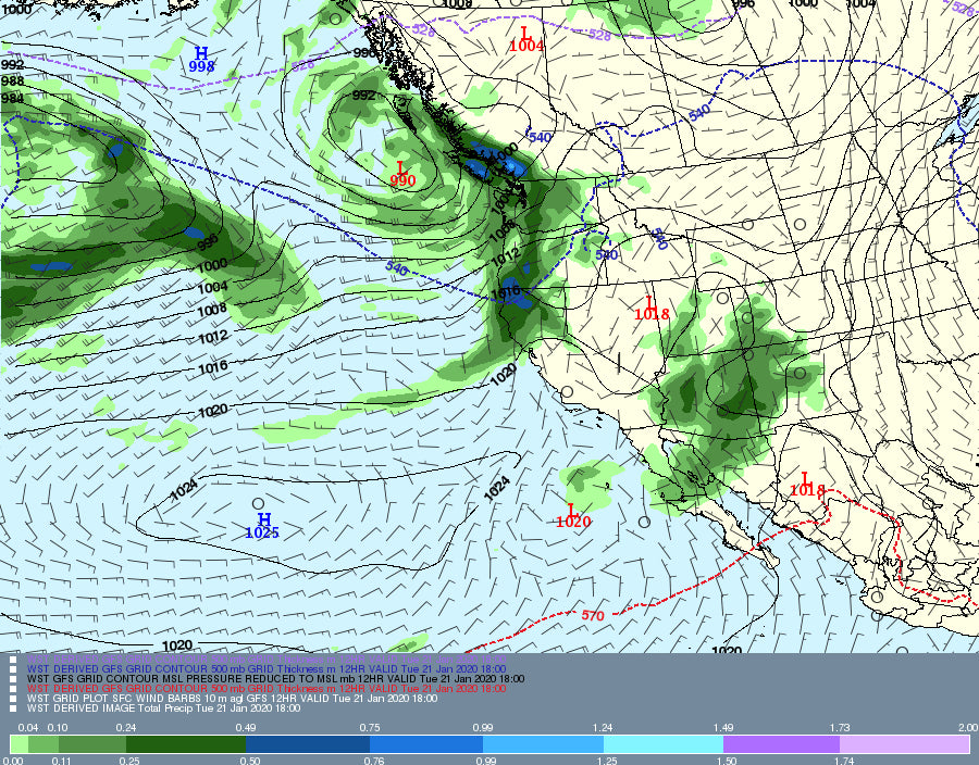
There are 2 systems to talk about. First is a strong low-pressure system entering the Pacific Northwest Tuesday morning that will bring increasing snow rates into Wednesday morning. The 2nd is a weak system brushing the 4 corners this Tuesday morning that will bring 2-3 inches to the San Juans initially before higher amounts develop midweek. The sum total of snowfall for the Wasatch and Tetons through Thursday may approach 4-9 inches. The Front Range of Colorado and the I-70 corridor get steady light snow through Thursday (Teasing 2-3 inches every 12-15 hours) that could provide decent turning conditions Wednesday or Thursday. Totals might exceed 8 inches in some spots of Colorado. The northern Cascades could end up with 12-18 inches.
FORECAST
Light snow is currently falling in the Cascades. The models all agree that the northern areas near Mount Baker will be favored. SW winds often pump the highest amounts to the north (Winds are S, SW). On the other hand, West winds often favor Stevens Pass where NW can be good for Crystal that gets blocked by Mount Rainier with SW winds. The current system is coming in with S, SW winds. That said, the actual models, especially the GFS show decent amounts for all areas of the Washington Cascades through Wednesday morning (including Crystal). Peak snowfall will be Tuesday early afternoon through Wednesday at daybreak. Splitting the model data, my official Wednesday POW forecast is 6-11 inches for Crystal (Includes some snow from Tuesday), 8-12 for Stevens, and 12-16 for Baker. Mount Bachelor is likely going to be in the 4-7 inch range. The Northern Panhandle of Idaho should score moderate snow for Wednesday morning. Temps warm significantly late Wednesday into Thursday with quality deteriorating.
Below: University of Utah averages of model runs for Mount Baker showing medium confidence for 10-20 inches through Wednesday night. The spread is pretty high with some means in the 10-inch range and others as high as 20-25 inches. We averaged these out in the forecast above.

Meanwhile, in the Rockies you can find 5-10 inches of snow over a 2 day period. WIth no single overnight or 12-hour dump, the Tetons look good for 3-6 inches for the lifts spinning on Wednesday and another 2-4 inches through Thursday. The Wasatch may come up a bit short (4-9 inches) with the peak being reported Wednesday (48-hour totals). The same extended period of light to moderate snow is in the model runs for Colorado especially late Tuesday to Thursday. Expect general trends in the 3-7 inch range along I-70 through Thursday with a few surprises possible near Steamboat, Aspen, and perhaps Crested Butte. The northern San Juan Range, including Silverton, may see higher amounts with the early snowfall that is falling on Tuesday (Short wave just now entering that region). The Front Range resorts just north of I-70 will also see snowfall (Eldora, Winter Park, Rocky Mountain National Park) from this event (3-7). The best day to ride powder will likely be Wednesday and Thursday.
Below: University of Utah Plumes (Averages all the model runs) shows good confidence (Tight lines) for up to 8 inches by Wednesday morning at the Alta Ski area. A few inches from those totals will fall on Tuesday.

Below: Same graphics for the mountains near Steamboat (Steady light snow through Thursday morning with improving conditons).

EXTENDED FORECAST
High pressure takes hold for the Rockies this weekend. The Pacific Northwest will stay in a wetter pattern this week with much warmer temps (Rain/Snow) before cooling for the weekend (Some additional snow). The Sierra may grab a deep warm storm for the weekend.
The pattern begins to get a bit more active early next week for the Rockies with several series of weak or moderate systems favoring the northern Rockies. It's really hard to nail down the significance and timing currently with flip-flopping snow levels and a bit of uncertainty. There is no clear signal of any one particular deep period (Confidence is low).
Below: Low pressure for the PNW and the Sierra (Warm) for the weekend. The Rockies stay in a high-pressure pattern.

Below: High pressure is retreating over the Rockies opening the door for some weak or moderate low-pressure systems early next week (Likely to favor the Northern Rockies).

Enjoy the powder everyone!
Powderchaser Steve


