
Summary: Currently, we are watching two waves of energy moving over the interior of BC and rapidly moving south, favoring the eastern Rockies. There could be double digits, especially near the Front Range Foothills near Boulder and ski areas east of the Divide. Frigid temps will bring wind chill readings to -20F in many places by Sunday/Monday. You can chase powder in Colorado by Saturday. A stormy pattern might evolve towards the end of January as the ridge hopefully breaks down.
This post is sponsored by Tire Rack, our preferred provider for wheel and snow tire options. Tire Rack is easily accessible in the West and is jointly owned by Discount Tire (Ship tires to your local store).
Forecast:
The models on Wednesday morning have not changed much from our post on Tuesday. The only change is that the Friday-Saturday system for the eastern Rockies comes in 2 pieces with a cooling trend Friday/Saturday with light to moderate snowfall for the eastern Rockies. A second shortwave and much colder temps follow from Sunday/Monday (2nd round of snowfall).
Below: REX Block pattern with high pressure parked off the west coast, forcing any moisture south or north. Moisture is limited to the northern coast of BC, with leftover moisture aiming around the ridge and sliding down over the eastern Rockies. A weak low is noted south of the ridge in CA.

Below: Rex Block pattern. Image: NWS SLC

Snowfall
Double-digit snow totals will most likely occur with upslope conditions on the front range of Colorado between Friday night and Monday morning. Saturday turns will likely approach 4-9 inches closest to Boulder (Eldora) and Winter Park, including Berthoud Pass. Totals might approach 6-12 inches by Sunday night with the arrival of a 2nd shortwave and even colder temps.
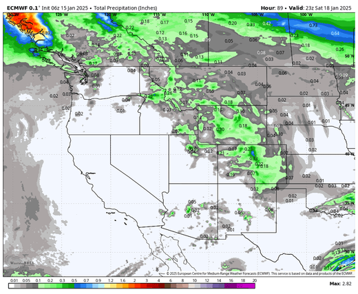
Below: Total moisture through Saturday morning is generally in the 1/4-inch range, confined to the eastern Rockies and interior BC. Slightly higher totals are noted near the MT/ID borders (Missoula area mountains). Widespread 3-6 inches are possible for these ranges, with the Wasatch likely onboard also (Light snow). The highest water totals are confined to the upslope flow (NE winds) in the Front Range, where 1/2 inch of moisture and cold temps may sneak out 5-11 inches near the Foothills that might extend to Eldora near Boulder and areas west to WP and Berthoud Pass. With 18:1 snow ratios, a 1/2 of water can still produce decent numbers.
Areas on the Divide will likely land lower totals (3-7). Areas west of the Divide, including Steamboat (Can benefit from upslope sometimes), should range from 3-7 inches (Summit, Eagle, Rout, Pitkin). The southern San Juan Range remains relatively dry.

Below: GFS moving map from Friday to Monday (January 20) with snow at 10:1 ratios (Totals will be higher with the ratios in the 18:1 or 20:1 range). The map shows the eastern influence and highlights over Boulder County and Front Range Foothills. You can see two distinct waves, the first being stronger on Friday/Saturday and another round of snow on Sunday/Monday.

Below: University of Utah GFS modeling showing an average of 3 inches for Alta on this storm.

Below: Winter Park ensembles show wide ranges (Low confidence) on average from 7 to 12 inches. I think this is a reasonable forecast. The lines approach 15 inches, with the second storm (Euro) and the GFS (Blue) closer to 9 inches (totals).

Below: the City of Boulder will score 5-10 inches or more with this storm.

Below: Temps are crashing from Friday night to Sunday, pushing down from BC and favoring areas on the backside of the ridge. (-20C at 10K or -4F)

Extended Pattern Change
The good news is that signals are increasing for a stormy period towards the end of January.
Below: The European is the most optimistic about the ridge starting to break down over the west between January 25 and 30. The GFS shows similar signals but is slightly less confident about the Sierra.

Below: Ensembles show good odds of significant snowfall for the last 3-4 days of January, highlighting the PNW, BC, and northern Rockies. Snow is also likely for the Sierra on this GFS ensemble (The deterministic GFS below shows snow confined further north).

Below: Fantasy The deterministic GFS model shows more significant 4-day snowfall totals ending on January 31st for the PNW and northern Rockies. This is more of a fantasy map beyond the confidence period of forecasting. Also, the GFS Deterministic model often starts very bullish (the ensemble data above is less bullish and shows snow dipping further south). Bottom Line: Pattern change is likely in the final 5 days of January. The exact track (Sierra vs PNW) is still unclear—likely higher totals for the PNW and northern Rockies. We could see some decent totals. You need to be ready to chase.

NOTE: Please support Powderchasers with a donation, merchandise purchase (such as a hat or stickers), or sign up for our custom Concierge Powder Forecast Package, where we provide 1:1 phone & email support to get you to the deepest locations possible. When chasing snow, the Concierge gets you the very best intel. Sign up for our free email list so you never miss a powder day. We are also seeking new sponsors and ambassadors who want to submit photos and videos (info@powderchasers.com)
Powderchaser Steve @powderchasersteve (Instagram) Forecaster.


