
It has been a crazy few days in the weather center, with records being set from Louisiana, Georgia, Florida, and Alabama. Up to 10 inches of snow fell in the urban areas of New Orleans, and close to 8-9 inches fell along the Florida Panhandle. Folks were skiing in these areas, being towed by cars (we can't suggest this), or, if lucky, finding a molehill.
Western Forecast: 3 systems to watch.
The upcoming weekend will feature a system digging in from the north over the eastern Rockies (Central Montana), edging west into northern Utah, and likely hitting higher numbers over north Colorado.
Below is the total precipitable water for the west through Sunday morning per the GFS American model. You can see some highlights, such as nearly .50 inches of water in central Montana, southern Wyoming (Skimning the Tetons with .25 inches), and a few spots in northern Utah and Colorado. The models have trended up slightly since this morning, especially for Utah. Areas south of Lake Tahoe might also sneak up a few surprises (Favors the eastern side of the lake and areas south toward Mammoth). The blue areas (1/2 inch of water) could equal snow totals in the 5-10 inch range by late Saturday night. Colorado has trended more consistently in the past few model runs.

Below: European models show nearly .25-.30 Inches for the Wasatch (less bullish than the American GFS above) but point to higher numbers south of the Wyoming border into northern Colorado by late Saturday (.50 inches or more of precipitation). In this scenario, widespread 5-11 inches would be possible for mountains along or north of I-70 in Colorado, with 3-7 inches for the Wasatch range. Steamboat might be favored here, but it's too early to speculate.
 A secondary wave pushes south of the ridge later this weekend into early next week, bringing some good odds of significant snow for the southern mountains of California (Rain for the burn areas near LA) and progressing east over the four corners or south.
Below: Total moisture, primarily from Monday to late Tuesday (January 27-28) per the European model, digs the low well south into Arizona, with some hefty totals possible in the central regions of AZ that trickle north into the San Juan Range (CO, NM). The southern Sierra can also do well (Big Bear, Mt Baldy). Map: 72-hour water totals from Sunday to late Tuesday night.

Below: The American GFS tracks the storm early next week further north, having better impacts on northern Arizona, southern Utah, and much of the San Juan range in Colorado and New Mexico (72-hour water totals shown through Tuesday night (January 28). The southern Sierra from Big Bear to Mt Baldy could do well in this pattern, with Mammoth a wildcard. We shall see which model pans out.

Longer-range models look promising.
The ridge might buckle towards the end of January through early February. There is good model consensus for a decent storm to impact the Pacific Northwest and BC, possibly extending into the Sierra in the first three days of February. Data this far out shows lower confidence; however, most models hint at a stormy period. These models will change as we get closer.
Below are 72-hour water totals from February 1-4, per the European model, which favors a slightly southern push over Oregon and extends south into the Sierra, Wasatch, and many areas of the Rockies, including Colorado.

Below: The GFS solution for the early February (February 2-4) Storm shifts the higher moisture totals north into BC and the PNW while tracking over Idaho, Montana, and the Teton ranges (Signficant moisture).

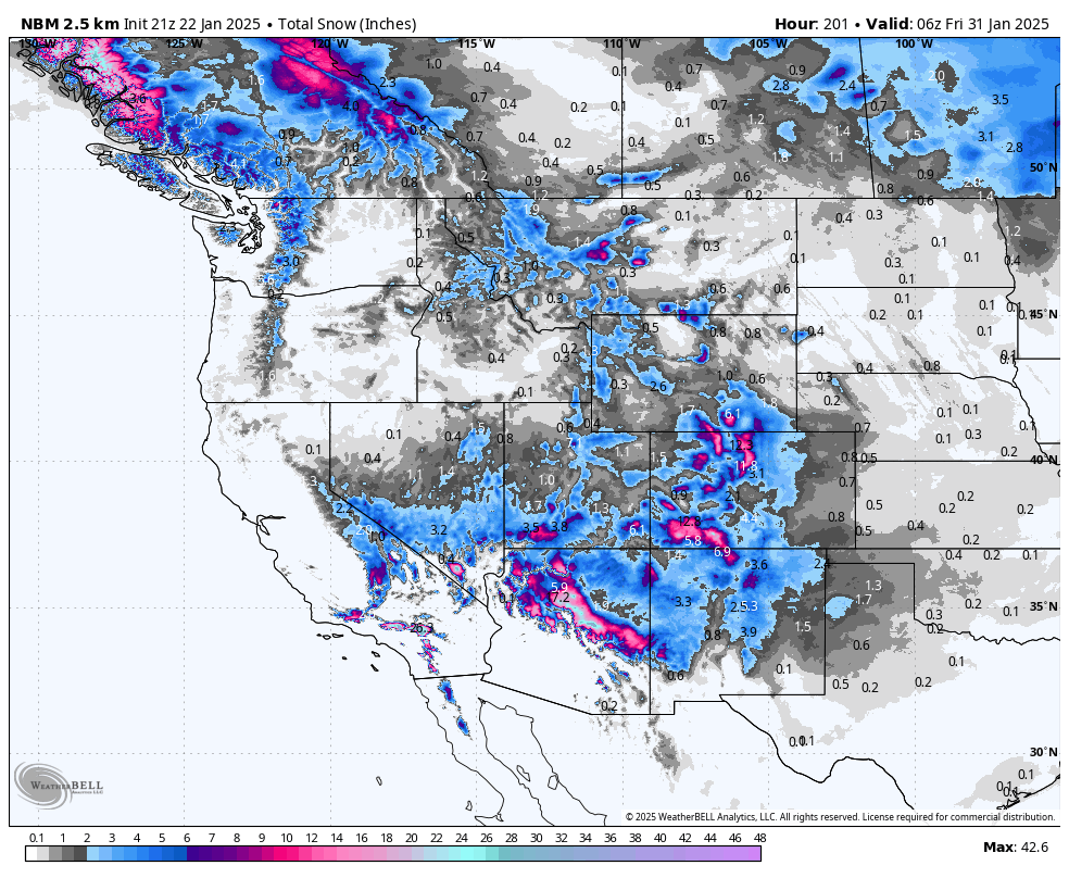
Below: Total snowfall through January 30th per the national blended models.

Below: Total snowfall through February 2nd as the subsequent stronger waves might impact the PNW and push south and east (Totals from January 22 to February 1st). These models are still uncertain about the February storm and combine all snowfall from today through the first few days of February.

NOTE: Please support Powderchasers with a donation, merchandise purchase(such as a hat or stickers), or sign up for our custom Concierge Powder Forecast Package, where we provide 1:1 phone & email support to get you to the deepest locations possible. When chasing snow, the Concierge gets you the very best intel. Sign up for our free email list so you never miss a powder day. We also seek new sponsors and ambassadors who want to submit photos and videos.


