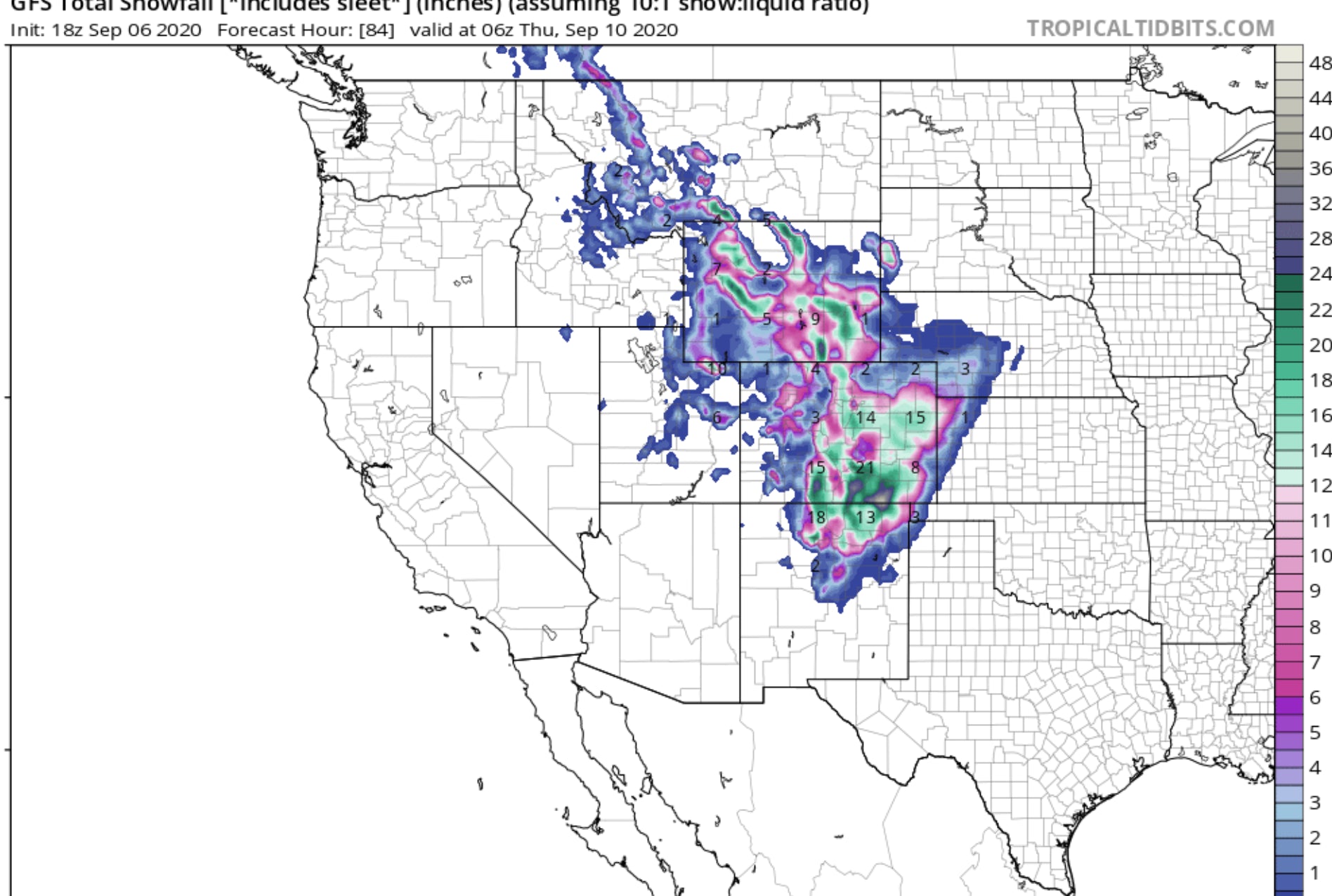
Very cold air from Canada and well below normal for early September will be bring December like temps to many areas of the Rockies. The brunt of the next storm will favor the Eastern ranges of Montana (Glacier National Park), Central Wyoming (Including the Wind River Range), Eastern Wyoming (Laramie Range), and most of the Front Range mountains of Colorado. Light snow is likely for the urban corridor of Denver. Decent amounts may be possible on grassy surfaces around the urban corridor Tuesday with less on the roadways.
The models last week held up with the Euro hinting at this significant storm cutting off in the 4 Corners by Tuesday. The GFS and Canadian were not onboard until just a few days ago. Consensus is high that a significant storm is likely especially for south central Wyoming, and most of Colorado favoring the Front Range and eastern San Juans in the south. Amounts will likely exceed 12-15 inches in these areas by early Wednesday. The bulk of Precipitation will fall late Monday-early Tuesday in Montana, northern Wyoming (Wind River Range) and mostly early Tuesday morning to Wednesday morning for Colorado. The GFS is pretty bullish for some moderate snow for the northern mountains of New Mexico, late Tuesday to Wednesday, especially near Taos (Euro showing less). Light snow showers will continue over the higher terrain of Colorado Wednesday/Thursday. Further west in Colorado (Copper, Vail, Aspen) 3-7 inches are likely Tuesday/Wednesday. Higher amounts are possible as winds shift from N, NE to NW at some point Tuesday afternoon behind the cold front. If the winds shift to the NW the mountains west of the Continental Divide will pick up higher amounts.
Is this really early September?
Below: 10K foot temps plunge to -8 to -10C from north to south beginning late Monday (Montana). You can see the coldest temps (darker greens) stay along or east of the Continental Divide. Utah and western Wyoming will see a cool down (-1 to -4) at the 10K foot level with some light snow possible. The Uinta Range may see higher amounts just east of the Wasatch range.

Below: University of Utah Plumes showing multiple model runs and still some discrepancy on amounts for Berthoud Pass by late Tuesday evening. The mean is between 5-10 inches. It's possible that Rocky Mountain National Park see higher amounts. Some lines on this graph (Outliers) show up to 15-20 inches for Berthoud Pass but it's unlikely.

Below: Wolf Creek Pass- University of Utah weather Plumes are very bullish for the Eastern San Juan Range. Winds are not optimal (N or NE for the Ski Area, however the models still show decent amounts especially on the eastern side of the pass. These averages are pretty bullish (10-15).

Below: Jackson Hole Ski area- Less bullish with the highest amounts further east towards the Wind River Range and Laramie peaks. These models runs show lots of discrepancy with the mean around 4 inches at the peak.

With regional travel up the winter, midweek and weekends, join our Concierge service for custom forecasting specifically for your needs. The includes snow amounts, winds, density, which resorts, and specific days to chase. All of our Concierge rates are going up on October 15th. Book early season for the best value. You can also donate to Powderchasers if we have helped you score powder. We are also accepting sponsorships and advertising so please send us an email from the contact form on the website.
Enjoy the powder everyone! Some crazies are bound to be out there with their rock skis this week. Just remember if you mess up now, you may be out all season.
Powderchaser Steve


