Good evening everyone. This is Forecaster Steve, with a Wednesday update on the upcoming storm system due for the Sierra and Rockies. It's hard to believe that we are chasing once again with the anticipation of blower pow in late April. The next storm starts out warm and finishes cold (Cover up the crud). The latest models show very high confidence for 12-18 inches for the Sierra Range by Friday with possibly 2 feet above 7,000 feet on the Sierra Crest. Temps start out very warm (it's nearly 70 in Reno Wednesday) with strong winds. Winds will decrease on Thursday somewhat, but it will still be breezy. Friday will see an additional decrease in winds. The next system is just approaching the coast of California Wednesday evening. Totals for Thursday 1st chairs may range from 6-10 inches with a bit of favoritism to the northern Lake region (Above 7,000 feet). Much less will be found at the bases (Most ski areas are skiing the summits now, however Kirkwood benefits from the higher elevation base). 1-2 inch per hour snowfall rates will likely await your first chairs Thursday as dense snow eventually turns lighter during the day.
Snow continues, heavy at times Thursday morning before a slight decrease in the afternoon (Additional 3-6). Temps will be cooling Thursday so quality will improve. Temps get downright cold for late April Thursday night into Friday where even Reno may see non accumulating flakes while the mountains continue to benefit from much needed snowfall. At this time, the models show another 5-9 inches Thursday night with perhaps a bit more near Donner Summit (Northern Lake) and further south towards Mammoth. Friday could be epic with terrain that did not open Thursday and our guess is that some areas will open new terrain Saturday (Perhaps Mammoth Summit). Storm totals should range from 12-24 inches above 7,000 feet.
IKON pas rates increase Thursday at midnight so be sure to check out the lowest rates below.
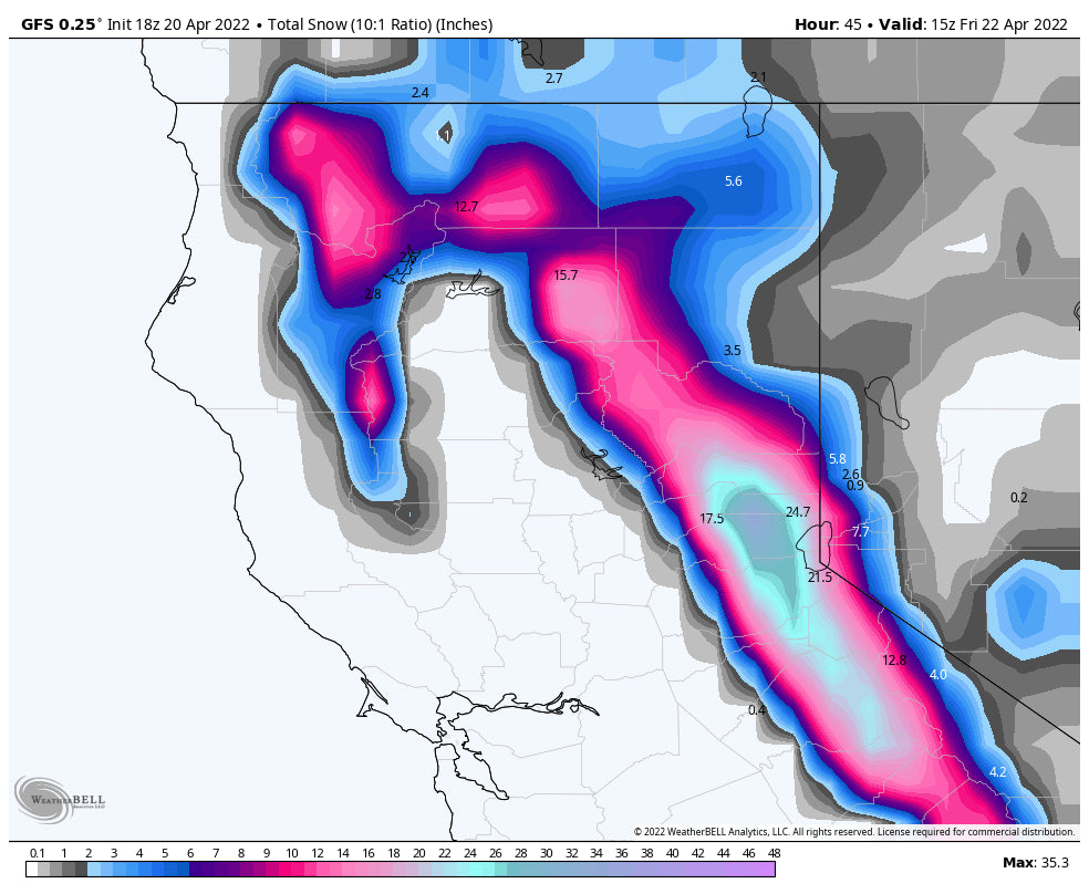
Below: Total snowfall for the Sierra through Friday morning. WOO HOO more snow than any storm in February or March. Some areas have already seen 2 feet in April prior to this storm. Many ski areas are closed so be sure to check before venturing on your chases. Treat closed ski areas as backcountry and respect closures to uphill travel.

For the Rockies the models are a bit uncertain on the Wasatch and even the Tetons. High confidence exists for 5-9 inches for the Tetons Friday into Saturday (Split day and night snow). Winds shift directions from SW, W, N, NW so it's possible that some upside or downside surprises occur. Some models show 9-15 while others in the 5-9 inch range Late Friday or early Saturday offer your best opportunity for snowfall in the Teton Range. Snow levels will be near the valley floor with some light snow falling in the town of Jackson Friday night. Our best guess on Teton totals will be 5-11 inches by Saturday.
Montana has higher confidence in 9-15 inches with Big Sky likely doing very well from this storm (Friday AM and PM).
In the Wasatch models also diverge on solutions. Generally this event will produce 3-7 inches for most of the Northern Wasatch Range including Park City Friday/Friday night- with higher amounts for the Cottonwoods. The winds start out strong Friday with heavy precipitation bringing 4-8 inches to the Cottonwoods by last chair. Friday night sees the favorable NW wind direction pushing additional snow into the Cottonwoods for Saturday. Winds will be on the downtrend Friday PM and Saturday. Some models show up to 2 inches of moisture while others much less. The average of most of the models is in the 9-14 inch range for the Cottonwoods by Saturday morning (Friday to Saturday totals), while the GFS is pumping out 20 inch storm totals (High side but likely overdone).
Below: University of Utah ensembles averages show low consensus for snow totals for Alta (7-15) with our forecast sticking to 8-14 through Saturday.: Heavy precipitation rates and wind will be evident Friday morning, with a more showery pattern Friday night into Saturday (Additional light snow continues). The American GFS Deterministic model shows 20 inches but we think it's overdone.

Bottom Line Utah: Decent storm Friday with storm skiing and additional snow for Saturday morning. Winds are strong Friday. Totals are split between Friday and Friday night so it might be a combo of hitting last chair Friday or first chair Saturday (4-8 and 3-7). There might be an upside on totals as mentioned above. Not a huge storm, but definitely good for late April. Quality will be decent later in the storm period.
Colorado grabs the leftovers late Friday to Saturday (Good timing) with higher amounts in the northern mountains (Steamboat-closed) or on the western corridor including Aspen and even Telluride (Benefits from NW winds). Best guess on amounts for Saturday is 3-6 inches along the I-70 corridor and 5-11 near Rabbit Ears or Independence Pass.
Enjoy the powder everyone! Please donate for our forecasts, forecasters, and especially if you scored powder. Remember, Thursday is your last day to purchase the IKON pass here at the lowest price from our website.
Powderchaser Steve


