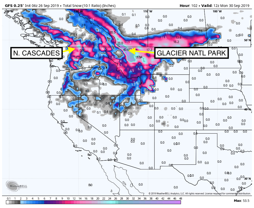
Models are very consistent for 3 feet of snow for a portion of northern Montana, especially east of Kalispell into Glacier National Park. Further west towards Whitefish lower amounts will fall, perhaps 5-10 inches at the summits. The town of Whitefish will grab its first valley snowfall of the season as temps drop through Sunday (1-3 inches). With better confidence mountains near Banff and even Revelstoke should score decent amounts of snow Saturday/Sunday. Very cold temperatures will increase snow ratios with what appears to be a double digit event for many ski areas in those regions. Snow will trickle down to Big Sky and Bridger Bowl albeit lighter amounts (4-8). Some surprises are possible. NE winds are not optimal for the Ski areas in that region.
Below: Canada is going to get a solid dump primarily Friday-Sunday.

Other areas the models are bullish for the Wind River Ranges of Wyoming, northern interior Cascades of Washington where several inches of snow will be falling this weekend. Areas of the southern and central Cascades will see lighter amounts. Its possible that the interior northern Cascades of Washington land 9-12 inches or more of snowfall by Sunday. At least most ski areas in Washington and even Oregon will see a tease of winter this weekend.
The Tetons and Wasatch are wildcards with moisture spilling into those ranges especially Saturday afternoon and Sunday. Temps cool significantly on the latter half of the weekend. Currently, we are keeping our alert cards in the pocket for these spots, purely due to non favorable wind directions and the coldest air arriving on the tail end of the moisture stream. While snow will be falling in all of these areas, it may stay on the light to moderate end of the spectrum (3-9). The highest amounts will be found east of the Tetons or perhaps in northern Utah on the Idaho border. Heavier amounts are possible for for the Pebble Creek Ski area in Idaho (Wildcard). In the Wasatch, we are more bullish for the northern areas, perhaps Snowbasin or further north (SW winds).
Below: Total snowfall through Monday morning - Epic amounts for North Central Montana. Surprises may be found in the northern interior Cascades.

The Chase: North interior Montana, BC, Alberta or the northern interior Cascades. Wildcards: Northern Wasatch , southern Idaho (UT border), Pebble Creek, Beaver. Whitefish is a wildcard.
Below: Light to moderate snow for the Madison and Gallatin ranges of Montana and the Tetons. Higher amounts further east in Wyoming and north in Montana.

Bottom Line: It's still September! Epic amounts of snow are going to be found in some isolated areas of the West. Canada may be off to a good start?
Powderchaser Steve


