Announcement: Powderchasers is looking for additional sponsors to be highlighted on our website. We are also looking for ambassadors to chase powder and send us photos and video content. Please reach out to us at info@powderchasers.com
On Friday, a cold system brought 7-9 inches to Whistler and is currently providing some moderate totals for the Cascades in Washington and northern Oregon on Friday.
Below: Whistler had roughly 7 inches early Friday morning, and as of noon Friday, most of the action was south of BC.

Snow has worked south into Stevens Pass, where a cold front combined with W and NW winds are bringing light to moderate snow to the I-90 corridor, with higher amounts noted near Stevens Pass.
Below: Stevens Pass received 6 inches of snow on Friday at 2 PM PST. This snow will likely continue for several hours before tapering late Friday night.

The models show an uptick of moisture moving south into Crystal Mountain on Friday afternoon (2-4 additional inches), with cooler air heading into Oregon later in the day. Thus far, Oregon has been on the warmer side of the colder air in Washington and BC. We expect an additional 2-4 inches for areas of the central and northern Cascades (I-90 north to Baker), with a chance of higher totals near Crystal Friday afternoon. Timberline and areas south to Bachelor should grab moderate totals Friday evening. Aim to chase powder for the last chair Friday or 1st chair Saturday as moisture lingers over the Cascades (Generally moderate totals from Friday day and evening).
Rockies and Idaho
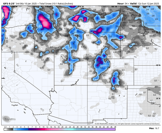
Below: We have highlighted several areas of the Rockies with moisture due Friday evening for the Montana resorts extending into Utah and Wyoming later Friday night. We are showing you water totals since snow ratios will be near 18:1 or higher due to colder temps (18 inches of snow for 1 inch of water). Liquid totals in many areas seem similar through Saturday afternoon, generally near 1/2 inch or slightly higher for many highlighted resorts.
In Montana, areas south of Bozeman appear higher, except for higher totals near the Showdown Ski area (Central Montana). Some models point to Montana's oldest resort grabbing 10-18 inches Friday night.
The central Panhandle of Idaho (6-9) will also do well on Friday afternoon and extend some lighter totals towards Missoula and the Montana Snowbowl. (3-6) Further west towards McCall, moderate totals will be seen (3-7) by Saturday morning.

We like the odds of 6-12 inches for Big Sky through mid-morning Saturday and 4-9 inches for the Tetons and extreme northern Utah (Beaver Mountain), with generally 4-8 inches for most of the Wasatch Range (Powder, Snowbasin, PCMR (Canyons side) and 6-12 inches for the Cottonwoods. The Cottonwoods show roughly 1/2 inch to, at most, 3/4 inches of liquid (8-12). If Lake effect kicks in, amounts could exceed the 12 inches we have on our forecast (Potential downside or upside).
NW winds will be strong initially Friday night in Montana and the Utah mountain ranges, providing reasonable hourly snowfall rates after midnight. Winds shift more northerly on Saturday and decrease. This might reduce the totals in the Cottonwoods after daybreak on Saturday when moisture intensity decreases a bit. Winds in Montana, Wyoming, and Utah mountain ranges will be strong Friday night and decrease on Saturday with the colder air and wind shift to the NNW.
In Colorado, the models have consistently compiled decent totals for the northern region near Steamboat (7-15 inches) by mid-morning Saturday. The western areas of I-70 will do better than the Divide. Aim for 3-7 inches for Summit County early Saturday, with 4-8 inches near Vail pass by midday Saturday. The models also highlight Telluride, which begins seeing snow by 5 AM Saturday and continues into the afternoon (5-10).
Bottom line chase? It is tricky to predict totals when most of the snow is driven purely by cold air and winds that will produce good lift over the mountain ranges. This system, while not very moist (1/4 to 3/4 inch of water), will create an excess of a foot of snow in some areas (Central Montana, Southern Montana (Big Sky wildcard), northern Colorado, and the Cottonwoods (Wildcard). There will likely be some double digits for 1st chairs in Montana, Tetons (Wildcard), Wasatch (Northern regions or the Cottonwoods), and northern Colorado (Steamboat). Some spots in the Cascades might continue to build with periods of light snow on Friday and Saturday.
The extended forecast dries things out next week as a ridge forms in the west. Moisture might start to return at near January 18.
Below: High pressure ridge noted for most of next week (Map is January 16).

Below: From January 18 to 21, we might see a backdoor system in the NE Rockies, combined with some moisture being pushed south by the ridge. This might favor the Front Range of Colorado or even areas to the south. It is too far out to forecast.
 Please support Powderchasers with a donation, Merchandise purchase such as a hat or stickers, or sign up for our custom Concierge Powder Forecast Package, where we provide 1:1 phone and email support to get you to the deepest locations possible. When chasing snow, the Concierge gets you the best intel. Sign up for our free email list so you never miss a powder day. We are seeking new sponsors and ambassadors who want to submit photos and videos.


