
A storm will overspread the PNW in the short term. This system moves over Idaho, Wyoming, Montana, and the Wasatch Range by Tuesday/Wednesday. That system brings moderate snow to the northern Rockies. The parent low stalls somewhere over Arizona and pulls deep moisture from the south and might bring several feet of snow to the San Juan Ranges, and the Front Range of Colorado.
If you are chasing powder, you could start in the PNW, or coastal BC Monday afternoon/Tuesday and chase through Idaho and the Rockies midweek to the weekend. Stay north and head south towards the end of this week.
PNW, BC
In looking at models for the Cascades on Monday decent moisture streams in by 3 PM Monday and cranks out snowfall through Tuesday PM. Peak periods of moisture will be Monday evening to early Tuesday morning. SW flow should favor Mt Baker and northern areas initially. This pattern will come with very strong winds Monday evening and brief warming temps until 5 AM Tuesday. Colder air and a wind shift to the West on Tuesday might improve quality with continued snow showers for the western Cascades. Convergence zones with the cold air and westerly flow will likely set up a band of higher snow totals for Snoqualmie Pass and Stevens at some point Tuesday midday into the evening.
Bottom Line PNW: Good moisture pushing a bit further south than the previous systems Monday afternoon to Tuesday (Oregon will also see decent totals in the northern regions). Winds are strong with the heaviest precipitation Monday evening (Snow quality might be impacted but could recover with decreasing wind Tuesday morning). Warming temps Monday will keep snow levels around 3,000 or 3500 (Dense initially). The cold front on Tuesday morning will add some blissfully nice powder to the surfaces as moisture decreases. Convergence zones might keep moderate to heavy snow showers going from Stevens to Crystal for storm skiing on Tuesday or new powder for Wednesday.
Rockies, Idaho,
Elsewhere in the west, look for some decent snow totals for the western Idaho mountains near Brundage (10) and moderate snow pushing north into Schweitzer and the Idaho panhandle (5-9) on Tuesday.
The Wasatch Range, southern Montana, and Tetons grab a moderate system from Tuesday mid-morning to Wednesday. The models show decent moisture near Big Sky on Tuesday AM( 4-9) and the Tetons (3-7 throughout the day). Snow showers continue in these regions Tuesday evening (Storm totals 7-14 for the Tetons). The Wasatch grabs Tuesday midday snowfall (2-5) with additional amounts Tuesday night (4-9). Storm totals in Utah will likely be in the 4-9 inch range for PCMR with 9-15 inches in the Cottonwoods. Timing is not perfect (split from day snow Tuesday and PM snow), however, NW flow in Utah Tuesday night could bring some decent totals for your first turns Wednesday. Southern Utah will do better later this week.
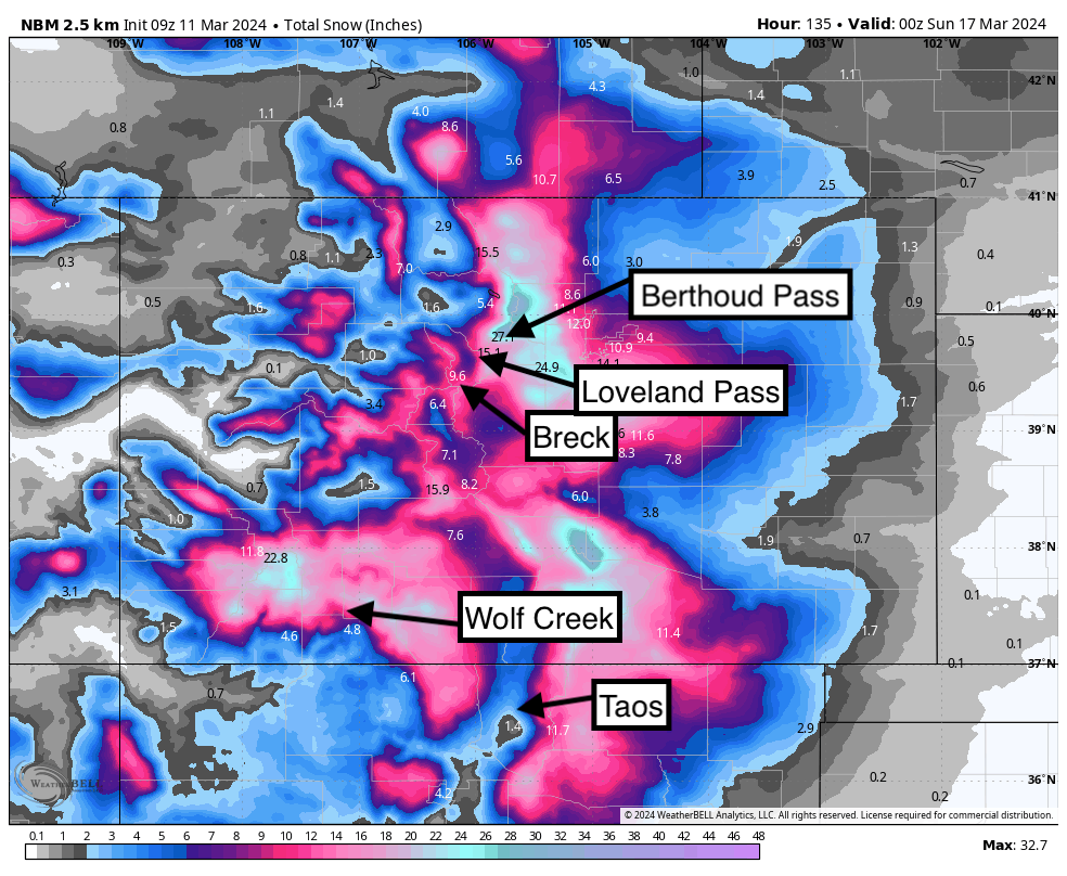
Colorado, Arizona, Southern Utah, and New Mexico are in play from midweek to Friday. Low pressure from the PNW that overspreads the northern areas Tuesday/Wednesday stalls and cuts off in Arizona mid to late this week.
The exact placement of the low will determine who grabs the highest snow totals.
Below: Low from the northern Rockies streams into Arizona by Wednesday and stalls through Friday. This will also draw moisture from the south (Mexico). The GFS shown here would bring a decent storm to the Front Range of Colorado with wrap-around snowfall with upslope flow Wednesday night and Thursday. As the low pushes further south heavy snow would also result for the San Juan Range, northern Arizona, and most of New Mexico.

Below: The European model pushes the cut-off low a bit further west which would result in a bit less snowfall for Colorado. You can see the differences in the 2 maps.

Below: National Blended Models currently showing significant snowfall likely for the Front Range Foothills, Divide Resorts (AB, WP, Loveland, BP, and RMNP) extending into southern Summit County, Salida (Monarch wildcard), Pikes Peak Range. On the western slope NW winds are noted for a brief period Tuesday night with some decent totals also possible by Wednesday with the northern branch of this low (The main low that moves through Utah on Tuesday night) over Steamboat, Aspen, and Vail Pass. The San Juan range including northern New Mexico will likely see the highest totals Thursday to Friday with the cut-off low later this week.

Bottom line: Northern areas score Tuesday/Wednesday. Southern areas including Arizona, Southern Utah, Southern Colorado, and most of New Mexico might score significant snow Thursday-Saturday. NE flow might favor resorts that do best with upslope (Eastern areas including Ski Santa Fe and Angel Fire). This system is so moist that orographics and wind direction might not make huge differences in totals with moisture directly overhead with counterclockwise winds.
There are uncertainties in confidence with the placement of the low (Small changes in positioning can make a big difference in totals). Hard to forecast system. These systems often slow down with timing. Storm in the Front Range of Colorado starts very warm so totals will likely be highest above 7,000 feet.
HELP US OUT! Please donate here to Powderchasers if you have taken advantage of our free forecasts. This Is our number one source of revenue. Free swag for you on all donations from $50 and up. $100 donations grab you a custom shirt also!
We have new Powderchasers shirts fresh off production for sale currently for just $32 (Front and back powder)


Don't forget if you want to chase powder to the best locations every time, join our concierge package here. This provides custom 1:1 consults. You won't miss the deep.
Powderchaser Steve (@powderchasersteve)


