Doing a forecast with so much to talk about is not an easy task. The end goal is \Where to chase powder\" With that in mind, we will try to get to the points of the good and bad, and the bottom line. There is way too much to talk about.
Announcement!
Powderchasers and our forecast staff are supported by our readership, so if you have not donated, please do so here or join our powder concierge program where we provide 1:1 trip planning for chasing, last-minute custom forecasts, and the best pow day of your life. Support our sponsors and be sure to follow our Instagram and Facebook page @powderchasers.
Please contact us at powderchasers1@gmail.com if you are interested in becoming a sponsor for the website and forecasts. Please support our current sponsors!
The Sierra gained the most powder up north with Mt Shasta reporting 27 inches on Sunday morning. Elsewhere numbers were much lower, however, It is still snowing with generally 7-9 inches being reported near the northern side of the lake (Palisades, SugarBowl) and 12 inches at Kirkwood. Mammoth reported 8 inches. These areas will creep up somewhat during the day Sunday as it continues to snow. Stick to higher-elevation resorts for better quality.
Below: Additional snow noted for the Sierra range primarily falling through late AM or early PM Sunday (Moderate amounts) and with a general cooling trend.

The Sierra warms up significantly on Monday with snow levels rising to 8-9K. This is not the time to be out riding! However, as everyone starts to dry out their soaked clothing Monday night temps fall significantly for early Tuesday morning. Snow levels might be at lake level at this time. I have no idea how things will ride Tuesday with a guess of a super deep cushion-dense layer with 2-5 inches of medium-density snow (It might not be bad depending on what opens). Between warm air, rising snow levels initially, and strong winds with each event, there are too many red flags currently to chase to the Sierra Monday or Tuesday (Maybe Tuesday delivers a surprise). Mammoth or June mountain gain some merit with the higher elevation with the risk that the summit won't open. Perhaps gamble on Mt Rose or Kirkwood as well. Bottom Line Cali: Find your powder on Sunday, Skip Monday, and look for a possible surprise for Tuesday morning.
For the Rockies and areas of Idaho, we are seeing some possible chase points beginning Monday/Tuesday. Snow will be pushing into the Sawtooth and Wood River Valley near Ketchum (Sun Valley) from Sunday to Monday (light amounts) increasing late Monday to Tuesday morning (5-10). Temps will also be warming with the arrival of the moisture so quality will be on the dense side at the bases, but will likely ride pretty well up top (Not as warm as the New Year Storm). Temps cool on the backside of the storm as moisture decreases on Tuesday. Total snow from Monday to late Tuesday will likely be in the 9-14 inch range). It's a gamble on SV on what will open especially on betting for the Back Bowls, which rarely pop during storms. Ride the upper mountain lifts.
The Tetons will do better on this storm than the previous one last week. It has a better moisture tap under S-SW flow (Moisture from the Sierra pushing north) with light snow Sunday/Monday turning a bit heavier into Tuesday morning (5-9 for 1st chair). Winds from the SW favor Teton Pass and JHMR, with Targhee possibly ramping up early Tuesday with a wind shift to the NW. Winds during the peak of moisture Monday night turn southerly for a while which is less optimistic for the Tetons putting a bit less confidence in our totals. The Tetons are a bit cooler than the Wasatch, especially on Tuesday. Sum totals from Monday to Tuesday could be decent.
The Wasatch looks to gain good moisture from Monday night to Wednesday. Strong winds Tuesday with warming temps will provide risks on snow quality and possible lift delays (Winds seem to ease a bit by mid-Tuesday). SW winds might favor BCC over LCC (Brighton) Tuesday. Snow levels will rise to nearly 7500 feet Monday night or early Tuesday (5:1 snow ratios) with rain possible at lower elevation resorts. Cooler temps move on Tuesday as snow continues albeit with a lighter intensity. Snow will likely increase again Tuesday night into Wednesday providing a better shot at decent totals, especially LCC and even the Park City (Legacy Canyons Side will do better than the core of PCMR). Temps will be cooling so quality could be decent for Wednesday at many resorts in Utah.
Colorado grabs the wrung-out moisture on Tuesday favoring Steamboat and areas south and west (Similar to the last storms). Temps are warm, so it might even be raining at lower-elevation resorts Tuesday. Areas east towards Summit and even Vail Pass will only see light snow. The San Juan Range could land a few surprises late Tuesday to Wednesday as strong southerly flow appears to increase the odds of 5-10 inches for areas north of Durango (Purgatory, Silverton, Telluride). We added Telluride to this list since winds shift to the NW on the backside of the moisture (Tuesday night or Wednesday morning) and that can be beneficial. Wolf Creek will also see snow into Wednesday morning with a bit lower confidence on amounts (South winds versus SW). Taos gets stuck with lighter amounts.
Bottom Line Rockies: Monday brings colder temps and light snow to many areas. Warming is noted from Monday afternoon to Tuesday as the bulk of the leftovers from the Sierra arrive in Central Idaho initially and spread into the Tetons and Wasatch. Cooler temps work in Tuesday from north to south. Snow continues, especially in the Wasatch range Tuesday night with quality improving. Snow shifts south on Wednesday for the San Juan Range in Colorado.
Below: Tuesday morning is showing decent totals for the higher elevations of Central Idaho, Tetons, Wasatch (Snowing), and even northern areas of Idaho. Some of these totals will fall on Monday with the peak intensity late Monday (Idaho) into Tuesday morning or midday (Wasatch and northern Colorado). Moisture shifts into northern Colorado Tuesday morning and might peak for the 4 corners on Wednesday morning. Temps are very warm with the onset of this storm so the quality might be lacking. It's a bit cooler in the northern areas of Idaho. Cooler air arrives in the Sawtooth Range after 4 AM Tuesday as well as the Tetons with quality possibly improving slowly (Gamble on elevation and quality). You will need to ride the highest elevations for any chance of not seeing cream especially the further south you chase.

Finally, the PNW will score several rounds of light to moderate snow from Sunday to Tuesday. While none will produce double digits, warm air currently (37 at the base of Baker) will eventually cool with the passage of several periods of moisture. Easterly flow is noted for the central and even southern Cascades (Stevens Pass, to Crystal) which might keep the ski areas cold enough for some decent quality. Interior areas near Mission Ridge, extending north to Twisp (North Cascade Heli) and northern Idaho towards Selkirk Powder Guides including Schweitzer will ride well into early next week. Conditions continue to improve with these waves.
Bottom Line PNW: Both Monday morning and Tuesday will offer some decent turning conditions for most of Washington (Western and the Interior). The highest amounts are noted for Stevens Pass, White Pass, Baker (Suffering from warm temps on Sunday), and Crystal as a wildcard. No single deep period, but a foot or more is certainly possible through Tuesday. Ride Monday morning or Tuesday morning.
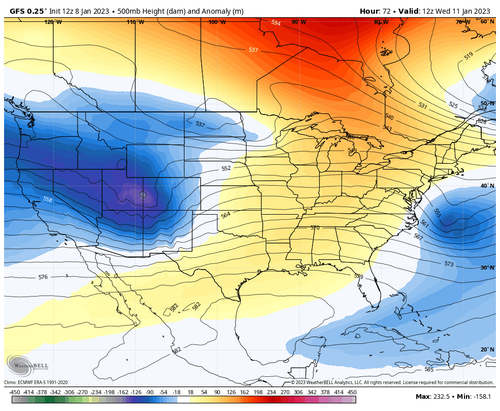
Below: January 11th- You can see the low pressure dropping into the 4 corners by Wednesday morning. The southern mountains of Colorado could fare well during the late Tuesday or early Wednesday period.

Extended
In taking a quick look t the extended, the Sierra is likely to finally get a break towards the end of next week. The period begins to get active again by next weekend with a continuous fetch of moisture and slightly cooler temps expected from January 14-26, especially for California. It's hard to determine how much moisture will hold together as these storms continue to impact the PNW, and north central Rockies. There appear to be several periods of moisture that will impact the west as the bulk of precipitation gets wrung out moving west to east. Our best guess is for several moderate or stronger periods of precipitation favoring the Sierra and PNW from next weekend into the following week (January 14-20). There might be a colder airmass moving into the west toward January 20th. Confidence is high in a continued unsettled pattern as we go into that 2nd to 3rd week of January with lower confidence on snow totals being 7-14 days out. This will get updated.
As an important mention, finally, New England might score a deep but warm storm by next weekend January 14th.
Below: The west might see a break in the action as we get into Thursday of the upcoming week (January 12). Maybe that's the window to ride the summits of some resorts in California that can dig out?

Enjoy the powder, everyone! Not an easy chase with a warm Atmospheric River but watch for the cold fronts! Please remember to donate or sign up for the Powder Concierge to support us! We are the only Powder Specific Forecast team that actually chases and provides you with free forecasts.
Powderchaser Steve - Follow on Instagram @powderchasersteve


