
SUMMARY
There is no perfect chase, but if you time the arrival of the cold front you might score 12 plus inches of medium-density snow. The deepest snow might not be your best chase. Higher elevations of the Sierra will grab 4-5 feet! Rockies and PNW grab Tuesday-Thursday options. Chase the colder portion of the storm.
Sierra:
Phase 1:
There are 2 significant pieces to the upcoming storm, especially for the Sierra and to some extent the Rockies. The first part of the storm phase is very warm and ongoing currently in the Sierra Range. Winds are going to gust well over 100 MPH for most of Monday in the upper elevations of the Sierra. Temps are warming with a Rain/Snow mix at lake level. Higher elevations Monday will see very significant snowfall (20-30 inches) by the last chair. The highest totals will be noted over the central and southern ranges from Kirkwood to Mammoth. Lower mountain lifts at Mammoth could be a good score Monday (Upper will 100% not open). Kirkwood may also be a good bet with its 8K base elevation. Overall, Monday might be the day to take a rest and await the 2nd and colder phase. Winds should ease a bit mid or later Monday but remain strong. My guess is that the majority of lifts in Tahoe on Monday will not be running (Lower elevation only). Stick to a higher elevation base and hope for lifts that are a bit more protected from the wind. Snow will be dense at all elevations. Bring surf gear.
Phase 2:
There is a break in the action Monday night with winds decreasing. The 2nd phase is the sweet spot with colder temps due for Tuesday morning and the return of snowfall. It's unlikely deep totals will be reported overnight, however decent snowfall rates early Tuesday and delayed openings could land some deep mid-density snow over much of the Sierra. Once again, the central and southern areas will see the highest amounts. Generally, look for 12-17 inches to fall on Tuesday as temps continue to drive downward (Snow level 4500 feet). Lowland snow is likely with 6-11 inches at the bases. Winds will also be decreasing on Tuesday. Look for some new terrain openings, but with all the mitigation Wednesday might be the day you start to see summit openings that could be epic.
Below: You can see warm air flowing into the Tahoe basin Monday followed by a decent cold front dropping temps to -8C by Tuesday morning as moisture increases again (Lake level snow Tuesday).

Below: Total snowfall at upper elevations through Tuesday night (Including Monday's warm phase and Tuesday's cold phase). Amounts will be in the 3-4 feet range and perhaps higher at the summits near Mammoth. Less snow will be found at the bases, however, Tuesday should bring a good push of snowfall to all elevations.

Chases outside the Sierra:
Moisture moves into Idaho on Monday peaking from mid-afternoon to late evening. Models have a downtrend from the original totals. Sun Valley is likely to see 3-5 Monday and another 3-6 Monday evening (6-11 storm total). SV reported 3 inches on Monday morning, much of which fell on Sunday. Further north in Idaho, 3-6 inches are likely for Brundage and Tamarack. SV might be decent for the last chair Monday or Tuesday morning depending on what stays closed on Monday.
Eyes turn to the Tetons and Wasatch for later Monday through early Tuesday. Snow will begin in the Tetons before the lifts close on Monday and likely wean by opening on Tuesday. Models show 6-11 inches favoring JHMR or the summit of Teton Pass. What's to like: Timing is prime for the Teton's overnight pow. southerly winds bring similar totals to lower elevations since there is less low-elevation shadowing from the mountains on a normal Westerly flow (Mountains shadowing the valley). What's not to like: Cold temps Monday migrate warmer Monday night (-4 or -5C at 10K) before dropping Tuesday morning as moisture tapers. Snow density will be on the high side at mid or lower elevations and avalanche danger might be on the rise with the increase in moisture content (Cold, Warm, Cold). Models are not 100% onboard with amounts (Some show 3-7, with others 6-12).
Below: Total precipitation by Tuesday morning showing nearly an inch of liquid for the Cottonwoods 1/2 inch in the Tetons and some moisture noted near Steamboat extending south towards CB. Some models show higher amounts for the Tetons and extending into southern Montana. This is the warm phase of the storm so amounts will be elevation dependent. The Tetons should stay at or just below freezing at the base with resorts further south that grab higher moisture totals will be slightly warmer. Most of the snow from this phase will be dense and some rain is possible at the bases of some areas.

Below: Snow rations at Alta showing a meager 5:1 (1 inch of water=5 inches of snow) from through the first phase of the storm Monday night. That's very dense snow! Snow ratios increase to 13:1 by Tuesday night. Low snow ratios Monday night might keep totals lower than what's being advertised on the models.

Montana should see some spillover of precipitation into Big Sky with 3-6 inches possible.
The Wasatch takes a bullseye on Monday night into early Tuesday. Slightly warmer temps than the Tetons. There are also 2 distinct phases similar to the Sierra. Warm and deep Tuesday (6-10 for the Cottonwoods by Tuesday morning- 3-7 for PCMR- DV and areas north to Ogden). BCC, especially Brighton might be favored over LCC.
LATE MONDAY UPDATE: snow intensity is driving down the snow levels to the Valley in Park City with higher totals through Tuesday morning increasing to 10-16 inches (PCMR/DV). This will include the mountain ranges outside Ogden and up to Logan (Beaver Mountain). The Cottonwoods will likely see higher amounts. This is only for phase 1 of the storm (Warmer phase). This update was issued at 4 PM on Monday.
Snow levels are rising to 7500-8,000 feet (Some valley rain likely even near some of the Utah resorts). Cooler air moves in during the day Tuesday with snow diminishing before increasing again Tuesday afternoon. This phase has winds from the south initially (DV can benefit) and will bring an additional 4-8 inches to PCMR or DV with higher amounts possible for Ogden area mountains especially Powder Mountain (Which does well with NW flow). The Cottonwoods will score another 5-10 inches for Wednesday morning (South SW and then NW wind direction= anyone can win). Solitude might be a decent choice for Wednesday as LCC will likely be closed for avalanche mitigation as early as Tuesday evening. Bottom Line: 2 inches of moisture were noted with an unfortunate warm phase Tuesday translating to a better event for Wednesday (colder). Increasing avalanche danger, road closures, and delayed openings are all likely for the Cottonwoods. Strong winds are apparent from late Monday to Tuesday morning. Wednesday will ski well depending on what opens. All mountains including southern Utah will benefit from this storm, especially upper elevations.
For Colorado, the 2 phases bring warm temps to Steamboat and an increase in moisture Tuesday morning. Some rain might be falling at the base. The warm phase of this event drops south towards Aspen, and especially Crested Butte Tuesday with dense snow likely during the day (Light to moderate amounts). Further east will see less snow. Phase 2 is colder due late Tuesday night into Wednesday morning. This phase seems to favor similar areas with Snowmass, CB, Silverton, and Telluride on my watch list for Wednesday (5-9 additional inches). Wolf Creek is a wildcard just east of the highest moisture stream. There is light to moderate snow noted on the models for the I-70 corridor and very cold temps noted for the Front Range. That cold air east of the Divide could kick off light snow Wednesday in the urban corridor and perhaps some upslope flow for the Divide resorts (Loveland, WP, Eldora, A-B- Storm skiing).
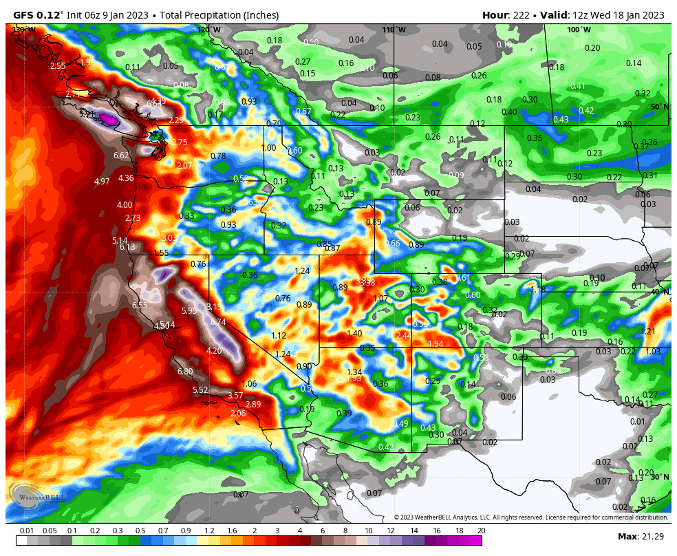
Below: Total liquid moisture for the Rockies through Wednesday morning (Phase 1 and 2). Some pretty hefty totals were noted for Utah. The southern areas of Colorado (Not shown) should also do well, especially on Wednesday. Snow will increase for the Front Range Resorts during the day Wednesday as moisture kicks north from the 4 corners as It pulls east.

Finally, in the PNW a decent storm is likely for 5-10 inches of snow from Wednesday to Thursday favoring Mt Baker, Stevens Pass, and to some extent the northern Interior resorts. Baker has 10 inches on the telemetry as of Monday morning (24-hour total). Warm temps in the PNW will cool with easterly flow and interior colder temps, especially near Stevens Pass and Mission Ridge for this next event. Further north or south could be warmer.
EXTENDED POW
Due to the magnitude of the events in the short term, I will broad brush the extended.
High-pressure returns late week for the Sierra (Dig out time) and the Rockies. Another stationary low-pressure trough appears to return to the west coast as early as the upcoming weekend sending ripples of moisture inland through much of next week. Storminess is expected to continue until perhaps January 22nd with high pressure possible for the Sierra, and a weak system that might continue for the eastern Rockies. The models are too far out to have confidence in the 14-day solution.
Please follow my Instagram feed at @powderchasersteve for the latest in powder and travel.
Announcement!
Powderchasers and our forecast staff are supported by our readership, so if you have not donated, please do so here or join our powder concierge program where we provide 1:1 trip planning for chasing, last-minute custom forecasts, and the best pow day of your life. Support our sponsors and be sure to follow our Instagram and Facebook page @powderchasers.
Please contact us at powderchasers1@gmail.com if you are interested in becoming a sponsor for the website and forecasts. Please support our current sponsors!
Powderchaser Steve


