
Overall Pattern:
The next few days will feature a decent wave of energy and cold temps for the Sierra favoring the northern ranges. This will bring in the coldest temps of the season thus far for Cali. The PNW has been deluged with rain after a great storm last week. Snow returns to the PNW as snow levels lower this week and early weekend. Warmer air briefly moves in Saturday night. The Rockies score leftovers that could be decent on Friday for some areas of Idaho, Wyoming and Utah. Colorado get the wrung out leftovers.
POW FORECAST
Sierra
The models have upticked snow totals for the Sierra with 2 pieces of energy moving in on Wednesday-Thursday. The first warmer section of the storm (Snow levels 6500-7500) teases the northern Sierra PM Wednesday to Thursday morning (2-5). The second piece is much colder (The coldest air of the season) and crashes snow levels to below lake level from Thursday PM to Friday. The highest totals of 10 plus inches will likely land near the northern sections of the lake along the Sierra Crest closest to I-80. Finally, there is something to talk about!
Below: Total snowfall through Thursday night with 9-12 inches possible favoring the northern Lake Tahoe region including resorts near I-80. Central and southern locations will see lower amounts in the 5-8 inch range. Further south towards Mammoth will see less.

Below: 10K foot temps in the Sierra crash to -10 degrees C by Thursday morning with increasing snowfall on the second round of precipitation into the evening. The first weak wave on Wednesday night will be warm (Dense 2-4 inches) with the second piece much lighter density on Thursday. These temps in the Sierra often produce good quality powder worth chasing if resorts were open with big bases. Expect some light totals at lake level on Thursday with road impacts on I-80 especially Donner Summit.

PNW-
The PNW has been deluged with record rains, flooding, and significant issues at ski areas. Crystal and most ski resorts will remain closed on Wednesday. (Crystal reopens on Thursday). The warm atmospheric river is weakening with some cooler air currently moving into the PNW as of Wednesday. By Thursday snow levels will lower to near 4,000 feet with 3-5 inches possible for many areas of Oregon and Washington (Wet pow on top of the damage from the past few days).
The outlook for deeper powder in the PNW looks best for the weekend when a double-digit storm is likely and even lower snow levels (Below the bases). This storm starts with SW flow (Baker is favored initially) but really cranks when the winds shift to the NW. Favored areas, will likely be from Stevens Pass and south to I-90 with a convergence zone setting up on Saturday.
Over an inch of water is likely in the PNW with this strong wave on Saturday/Sunday.
The Good: Double-digit snow totals Saturday/Sunday with very cold temps initially below the bases. The Bad: A warm front moves in late Saturday pushing snow levels up above 5,000 feet before it cools again on Sunday (Storm starts out with good density Saturday morning, Wetter snow late Saturday, Rain dependant on elevation Saturday night followed by cooling midday Sunday). Hopefully, this storm will allow the PNW to recover a bit.
Rockies:
Our overall synopsis is that 2 waves of snowfall are upon us through Saturday. The highest totals will likely land in western Idaho (Brundage, Tam) and extend south to Hailey (Decent totals). Southern areas seem favored, perhaps even just south of McCall. Sun Valley gets teasing leftovers as the Sawtooths soak up most of the moisture just to the north on Thursday/Friday. Expect 5-11 inches for many areas of western Idaho and even the central Panhandle.
The Tetons are in a good scoring position for some light or moderate snow on Wednesday night to Thursday Another wave arrives Friday. Totals in the Tetons will likely be from 6-11 inches by late Friday. Caveat: Peak snowfall is likely late Wednesday night or early Thursday (Mix of overnight snow and day snow). Friday might be the better day with additional totals. Not a huge storm, but should perform near or slightly above double digits. There is an upside with this storm due to colder temps. Northern Teton Range closer to Yellowstone seems a bit favored (Moose Junction etc.). Might be worth a chase.
Below: U.U ensembles are coming into better agreement of 2 waves of snowfall for the Tetons due Thursday morning and again into Friday. Consensus on this ensemble is 6-12 inch totals with high confidence and an outside chance (Outlier lines) of up to 15 inches (Models are trending higher totals in the northernmost Teton Range closer to Yellowstone). Storm Ski Thursday or some new snow from Thursday night into Friday (Lighter end of the storm cycle).

Utah: Snow showers develop Wednesday night and Thursday favoring the northern Wasatch (Beaver Mountain, Idaho border) with generally light or moderate totals. A stronger wave will hit the Wasatch early Friday morning with 6-11 inches for a widespread area of northern Utah (Split between snowfall from Thursday night and snowing during the day Friday). Some lake effect snow is possible that could increase totals in the Cottonwoods to 11-16 inches by late Friday night. Storm ski Friday with some additional snow for Saturday morning. Bottom Line: Not a huge storm with moderate totals for many ski areas (5-10) and some upside potential in the Cottonwoods. Snow is split from overnight to storm ski (Not a huge overnight dump) into Friday.
Colorado grabs weakened leftovers Friday/Saturday with generally 3-7 inches favoring a wide area of the northern and central mountains. This is not going to be a big storm. Some models are showing a decent band moving over the northern Front Range near Boulder this weekend which could uptick totals near Eldora or RMNP. Winds veer from NW to North by late Friday so it's possible areas near the Divide including Keystone score higher totals. The best day to ride will be late Friday or early Saturday. Totals for Colorado will be updated on the next forecast as my confidence is a bit low at this point.
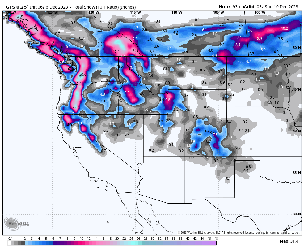
Below: Snow totals for the west through late Saturday. The PNW will score some decent totals early this weekend before a brief warm-up late Saturday night. Cali finally scores a cold storm favoring the northern Sierra Thursday. Idaho, Wyoming, and Utah are good picks for Thursday-Friday. Colordo might perform late Friday to Saturday but it's a bit far out for confidence on anything deep.

Extended
After this departing storm this weekend, colder temps and some snow showers are in the models for some areas of the west. We don't see any significant storms next week.
A low-pressure system might land over the Sierra around December 16/17 that might take a southerly route over the west. It's too far out to predict with accuracy. Perhaps Arizona or the 4 corners score some powder with this wave? if this happens some moisture might return in the December 17-19th period.

ANNOUNCEMENT:
Zoleo has a killer sale on their satellite communication devices through December 13. Currently $149 for the device ($200 MSRP) and promo code POWDERCHASERS waives your activation fee ($20 value). We travel with a Zoleo in the backcountry to have communication beyond cell service!
Please join our powder concierge program to support powderchasers. This program provides 1:1 forecasting, chase locations, and custom trip planning to get you in the deepest snow with each storm. You can also donate on our website or purchase some swag to support us. This keeps the free forecasts going. Any Donations of $50 or more get you free swag (Shirts and stickers). Please support our Pow Cast.
Thanks for following
Powderchaser Steve


