The past several days have been very active for the west, with some very deep snow totals in the PNW and Rockies. The Rockies grabbed cold freshies with the PNW getting deep by Sunday morning when all the action changed to rain at lower elevations. The good news is that the amount of rain in the forecast for the PNW is minor and many ski areas announced openings this week (Baker, Stevens). This past storm might be good for base building especially for Baker and Stevens who saw the most snow. Less snow fell south of I-90.
Below: Baker snuck out 17 inches from this last storm with temps climbing to above freezing by 9AM at 5K. There is not much precipitation noted past 9AM so the amount of rain may have been minimal.

The Rockies scored "big time" especially the Wasatch Range, Western Tetons, and most of north/central Colorado. Idaho also scored some decent totals (5-10) for Ski Lookout and Brundage Mountain.
Here are a few storm totals from the past several days (Lots of new open terrain popping).
Big and little Cottonwood (Solitude, Alta, Brighton, Snowbird) 24-28 inches
Park City 12-15 inches
Mt Baker 18 inches
Stevens Pass 15 inches
Vail 19 inches
Aspen 11 inches
Brundage 10 inches
Snowbasin 14 inches
Beaver Mountain Utah 24 inches (Per text on their website)
Powder Mountain 15 inches (Estimated)
Future Pow? Where? How Much? Hope?
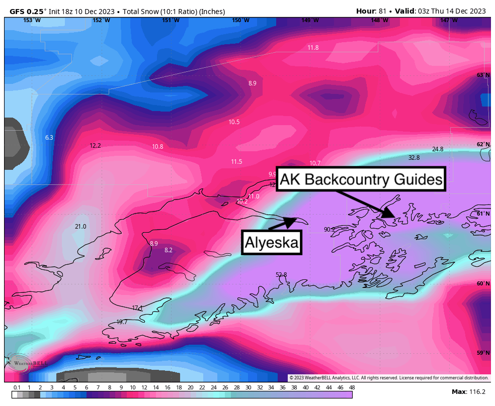
The models don't provide us any hope of deep snow short term aside from Alaska. High pressure will dominate the west through next weekend aside from a few outliers. Alaska should score 20 plus inches at Alyeska Resort and upwards of 50 inches near the backcountry zones near Valdez (Alaska Backcountry Guides).
Below: Alaska will be deep this week and perhaps again next. Temps start out very cold with slowly rising snow levels to 3-400 feet by midweek (That is still respectable).

Rockies, Sierra, PNW
There is weak moisture ongoing in the Tetons Sunday where we only predict 1-3 inches (Weak scraps). That system drags over Colorado on Monday and will bring light snow to areas north of I-70 and perhaps the Front Range (RMNP, Eldora). Most models don't show much in terms of accumulations.
Below: Total snowfall through Saturday December 16th. Coastal BC will likely score some moderate freshies towards the end of this week dragging leftovers into the interior. Weak energy noted for Idaho. A low pressure system quickly moves through New Mexico midweek with most models showing light accumulation with a few pumping out some decent numbers. The core of the Rockies and Sierra stays dry with seasonably cool conditions expected. Maybe NM gets lucky Thursday?

Below: High pressure dominating the west with a trough exiting Colorado noted to the east Monday/Tuesday. 
Below: Fast moving low pressure trough tracking through Arizona and New Mexico by Wednesday night December 14th might bring some snowfall to northern NM or extreme southern Colorado.

Below: In the period beginning December 18th (Week #2) there is a signal of a low pressure trough that might sit along the CA coast and drag south (Versus inland track). This is too far out to speculate. If we get lucky the models will push this inland but our confidence right now is low being more than 7 days out.

Powderchasers has partnered with Alaska Backcountry Guides in Valdez as our preferred vendor for Heli Skiing for the past 4 years.

Please join our powder concierge program to support powderchasers. This program provides 1:1 forecasting, chase locations, and custom trip planning to get you in the deepest snow with each storm. You can also donate on our website or purchase some swag to support us. This keeps the free forecasts going. Any Donations of $50 or more get you free swag (Shirts and stickers). Please support our Pow Cast.
Powderchaser Steve


