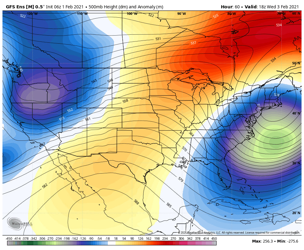
The highlights for chasing powder will be in the Sierra for Tuesday morning and a good portion of New England. Heavy snow will fall on both ends of the map. The Rockies and especially Colorado stand a good chance of a moderate or slightly better dump for Wednesday/Thursday.
EAST:
Snow is already falling in the Tri-State metro areas of New York. This will slowly move up the coast peaking snowfall rates over southern New England late Monday night into Tuesday morning. The highest totals will likely come from southern New Hampshire (Gunstock), Western Massachusetts (Berkshires), Boston Metro (Wachusett), initially Tuesday morning. Southern Vermont will also score decent amounts so an early chase Tuesday will also be possible (Amounts will be lower than the coastal resorts). A dry slot seems to exist in central or northern New Hampshire, where slightly lower amounts are likely over North Conway.
This storm is moving slowly with north progression into the Gulf Of Maine likely Tuesday morning to Wednesday morning. Significant snow will fall over north/central Maine with Sugarloaf, perhaps Sunday River scoring decent amounts for storm skiing Tuesday late AM and a deeper powder day by Wednesday morning.
Chase southern Resorts Tuesday and northern resorts for Wednesday morning!
Northern Vermont will be seeing snow Tuesday/Wednesday as moisture wraps up from the south. Expect 3-7 inches by Tuesday morning. The models show a reinforcing shot of snowfall for northern Vermont Tuesday night. There could be some surprise totals that come in for Jay Peak or Stowe for Wednesday morning if that band develops as the models advertise.
Below: New England Powder through Wednesday morning. Highest amounts for southern New England and a good portion of Maine. Northern Vermont could sneak up some decent amounts late Tuesday into Wednesday with a secondary piece of energy for the Green Mountain Range. Chase south Tuesday and north into Maine or Vermont for Wednesday (Score pow both days). North-central Maine will likely come up with the deepest amounts.

WEST:
The Sierra will be a solid bet for Tuesday morning powder (3-7) and storm skiing through the last chair (Additional 4-8). Additional snow will fall Tuesday night (3-6). The entire Lake Tahoe region will do well with his system (11-18 inches). Mono County (Mammoth) might come up slightly lower. The Good: Decent amounts of snowfall, lighter winds than previous storms, cooling trend (Right side up powder). Caveat: Not likely to see any overnight double-digit dump with the best moisture arriving after midnight through midday Tuesday.
Below Total Snowfall for the Sierra through Wednesday morning. Northern areas are favored. Ride powder Tuesday and Wednesday.

The Cascades continue to nab moisture this week with over 27 inches at Mt. Baker in the past few days. Crystal reported 8 inches Monday morning. The temps are warm with creamy snow likely until a cool down occurs on Tuesday/Wednesday. SW flow will favor the northern Cascade Range of Washington early this week including the north interior (Mazama). That will shift south by late Tuesday with some decent amounts possible over Stevens, Crystal, White Pass, Snoqualmie, and northern Oregon by Wednesday morning. Winds shift to the NW favoring cooler temps and driving moisture further south.
The Rockies grab snowfall after midnight Tuesday through Thursday. The Tetons, southern Montana (Big Sky, Bridger) will see the highest amounts during Wednesday (Moderate amounts). Storm Skiing Wednesday could deliver the deeper goods by mid-afternoon, especially in the Tetons. The Wasatch are in a similar pattern, perhaps 3-4 hours delayed on Wednesday that could continue into Wednesday night. Storm totals for Utah are still in question with models showing a widespread 5-10 inch event, with some hinting at as much as 11-16 inches for the Cottonwoods by Thursday morning (I'm going with 7-13 for the Cottonwoods currently). More detail on a later post. This will a storm ski type of storm versus a deep overnight dump like the last one.
Colorado will do well once again with NW flow favoring the central and northern mountain ranges. The models show the highest amounts between Steamboat and Aspen with decent amounts also coming in for Eagle County (Beaver Creek, Vail, and as far south as Telluride (Likes NW winds). Amounts in the favored NW flow regime and west on I-70 could see upwards of 6-12 inches. Resorts further east into Summit will likely see less (5-10). Even the southern San Juan Range from Silverton to Wolf Creek will score some powder with some likely decent amounts for Thursday morning. Overall, this is a good set up for widespread snowfall for Colorado.
EXTENDED
NW flow and cooler temps continue for the Rockies into the latter part of the week. This pattern will keep snow showers going from many regions of Montana extending into the Tetons and north/central Colorado. It's possible to see several light refreshes each day. More details in a later post. We might enter a regime of warming or high pressure in week #2.
Below: Ensembles for Saturday show a continued trend for some storminess lingering over the northern Rockies favoring Montana, Wyoming, and Colorado late this week.

Enjoy the powder everyone! You can follow me on Instagram at @powderchasersteve
Powderchaser Steve


