Excitement looms when we see multiple low-pressure troughs and several areas to chase snow.
Below: 2 low-pressure systems later this week. The northern branch impacts the PNW and northern Rockies while the southern branch takes direct aim at the Sierra. Many areas in the west will receive snowfall from Friday into the weekend with Colorado grabbing the goods early next week.

Sierra Deepness
The Sierra will be a sure bet for 1.5 to 2.0 inches of moisture from Friday PM to Sunday AM. The models have been consistent with this storm, but a bit fussy about who will see the deepest totals. Snow begins Friday afternoon in much of the Sierra ranges, with slowly dropping snow levels into Saturday morning (Above lake level initially until the temps drop steadily late Friday night/Saturday).
Winds will initially be strong on Friday (Gusts 55-65 at the peaks) decreasing Saturday and Sunday (For once we get a Sierra storm with less wind).
Snow totals will likely range from 12-18 inches at 7,000 feet (7-9 at lake level). For Saturday morning powder some models show higher overnight totals in southern areas towards Mammoth with snow filling in further north on Saturday while the lifts are open (Storm ski day Saturday). First Chairs Saturday will see fresh pow nearly everywhere but sneak out some higher early AM totals to the south (TBD).
Snow continues albeit with lighter intensity Saturday night to Sunday (Sunday brings another powder day).
Bottom Line Chase: Very few red flags, Decent totals Friday night to Saturday with storm skiing. The big numbers might occur early Saturday while the lifts are open reducing the overnight totals, especially up north. More pow Saturday night to Sunday coating the snow with a bit more fluff for early turns. The only red flag is the warm temps this week and slush bumps. This storm comes in warm and finishes on the cool side (Not blower but not cement either). That is a good thing to cover the crud.
Below: Warm temps on this map for Friday afternoon -6C at 10K) migrate colder by midnight into Saturday (-10CF at 10K). Those are respectable temps for medium density or better snow quality (Storm finishes colder). Winds initially Friday night might dense things up a bit.

Sponsor Alert: Ikon early season pass rates just released. You can renew or purchase new passes here. at the lowest rates.
Also, as temperatures warm up, remember how important it is to wax your skis and boards. Our wax sponsor Purl offers 15% off all orders using coupon code POWCHASERS at checkout.
Rockies, PNW- Canada
The midweek system (Tuesday night- Wednesday) is still on track for the interior of BC and Alberta. Alberta will likely see higher totals with colder temps (5-11) with interior BC grabbing less (3-6). Kicking horse and areas towards the BC/Alberta border are in a better position midweek.
While so much attention is focused on the Sierra this weekend, the PNW will be in a slow-build situation with snow noted on the models from Saturday through the extended into next week. It's hard to pinpoint the heaviest activity. Expect 2-4 inches nearly every 24 hours (Isolated higher amounts noted near Stevens Pass) with higher totals for the following week (Extended below). Temps are warm this week (60's, 70s in Seattle) and will slowly drop by Saturday. Respectable 3500 snow levels by late Saturday with continued light snowfall. The result by early next week will be 10-18 inches for many areas of the PNW (WA and OR and areas of Idaho). This will be over a several-day period.
Montana who has had many storms miss them should be in the flow with this system. The Wasatch will start slowly on Saturday under SW flow (Storm ski) peaking into Sunday morning with winds shifting NW (Some model variance with a cold front due late Saturday).
Below: Models are not in synch (GFS is shown below- Euro is pushing higher totals south). This storm will likely bring decent totals to Montana including Montana Snowbowl and areas south towards Bozeman. The Teton range is also going to score. Timing: Saturday/Sunday. If the European model proves correct, we could see slightly lower totals for Montana vs. 10-15 shown below. Utah will fire somewhat from later Saturday to late Sunday (7-15 with a slow build up).

Below: U. Of U ensembles showing a decent consensus of 10-23 inches possible for the Tetons over 4 days through Monday, March 25 (Thursday PM to Monday) These tend to be a bit bullish at times so we are going with 9-15 for the weekend and an additional 3-6 into Monday.

Below: Ensembles for Big Sky are also optimistic this weekend (10-20). Decent confidence.

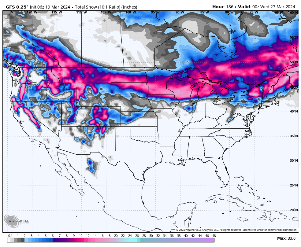
Below: Total snowfall per the GFS showing 10-20 for the Sierra through Sunday, Decent totals in the PNW through early in week #2 (Slow build-up), 12 plus inches for most of Montana and the Tetons (Peaking this weekend), and 7-15 inches for the Wasatch (Peaking Saturday midday to Sunday). Colorado will grab light-moderate totals this weekend and peak Monday-Tuesday in week #2 (9-15 for many mountains and perhaps the Front Range March 25-27).

Below: Meanwhile in New England, Saturday will bring storm ski conditions to many areas favoring the central and northern regions per the GFS model. There is also another scenario pushing some higher totals south. Sugarloaf and areas of northern Maine might see a precursor storm before the main event on Saturday.

Below: The European model shows higher totals in southern and central Vermont versus the GFS above. All are pretty consistent for an area in central and northern NH and Maine (N. Conway, I-93 corridor, Sunday River, Sugarloaf) as good targets. Temps start cold and finish warmer on Sunday (Might create snow quality issues by Sunday). Storm Ski on Saturday.

Extended
We have addressed much of the extended above. Look to chase from the Sierra or northern Rockies this weekend towards Colorado for early next week.
Below: Another low pushes into the west by Tuesday, March 26, and will advance into the Sierra and Rockies at some point mid-next week. The PNW will continue to stay active. You can see the departing low over Nebraska and the new system entering the coast of Oregon.

Below: Model accuracy is not good this far out. The system that comes ashore mid or late next week seems to take a southern route over CA and into the 4 corners before heading north into Colorado by April 1st.

HELP US OUT! Please donate here to Powderchasers if you have taken advantage of our free forecasts. This Is our number one source of revenue. Free swag for you on all donations from $50 and up. $100 donations grab you a custom shirt also!
We have new Powderchasers shirts fresh off production for sale currently for just $32 (Front and back powder)


Don't forget if you want to chase powder to the best locations every time, join our concierge package here. This provides custom 1:1 consults. You won't miss the deep.


