
A major storm is making landfall in California on Friday morning, marking the start of an extremely active pattern for the next 10+ days.
For the Sierra, snowfall will last from Friday morning through Sunday evening. Temperatures will start warm with snow levels above 7,000 feet. This means lots of rain and mixed precipitation until things cool off and the snow level drops below the lake on Friday evening/night. Friday night will bring 8-14" of fairly heavy snow for resorts along the Sierra Crest (Palisades Tahoe, Sugar Bowl, Kirkwood), 5-10" for central Tahoe resorts (Northstar, Homewood), and 3-7" of overnight snow for eastern Tahoe resorts (Mt. Rose, Diamond Peak, Heavenly). Resorts on the east side of the lake will see higher quality snow due to higher elevations and thus colder temperatures and fluffier snow. Mammoth will see 4-7" overnight.
After the cold front passes through on Friday night, temperatures will drop dramatically and will bring higher quality snow for the remainder of the storm.
On Saturday, Tahoe winds will be marginal, right on the edge of closing upper elevation lifts. Keep expectations low and don't expect upper mountains to be open, but know that there's a fairly good chance that resorts will be able to open upper-mountain terrain. Saturday will bring a few more inches to Tahoe and an additional 3-5" at Mammoth.
A final push of snow on Saturday night and Sunday morning with light winds will bring another 2-10" of snow to the region with the Sierra Crest being favored. Below is the ECMWF (left) and GFS (right) for that additional push of snow on Saturday and Sunday:

Utah:
Precipitation in the Wasatch will kick off on Saturday evening and remain heavy through Sunday morning (with lingering snowfall bringing several more inches after that). Snow quality will increase throughout the night as temperatures drop. The best day of skiing will be on Sunday with fresh snow, low temperatures, and low winds.
In terms of totals, resorts in Utah should pick up 4-8" overnight on Saturday night with 9-12 in the Cottonwoods. Lingering snowfall early next week should push totals up to 12-20" (Several light or moderate periods) in the canyons before the next storm hits on Thursday that will be stronger (more on this later).
Colorado:
Snowfall in Colorado starts on Saturday evening and lingers into mid-next week. The models are still very divergent on who will win from this storm. Just check out how much uncertainty there is by comparing the ECMWF (left) and GFS (right) solutions for forecasted snowfall by Monday evening:

They're both optimistic about the San Juans doing fairly well in the south. The GFS is throwing a lot more moisture in the central and northern mountains, especially in the Front Range. If that solution pans out, that would be great news for Eldora, Arapahoe Basin, Winter Park, and other resorts on or east of the continental divide.
We'll have to wait and see what solution the models converge to nail down totals for Colorado.
Announcement: If you want to Heli ski our trusted partner Alaska Backcountry Guides has 3 seats open from 4/14 to 4/20. All bookings earn you a Powderchasers swag bag including a free concierge membership for next season!
Extended forecast for the west -Plus New England Powder Alert
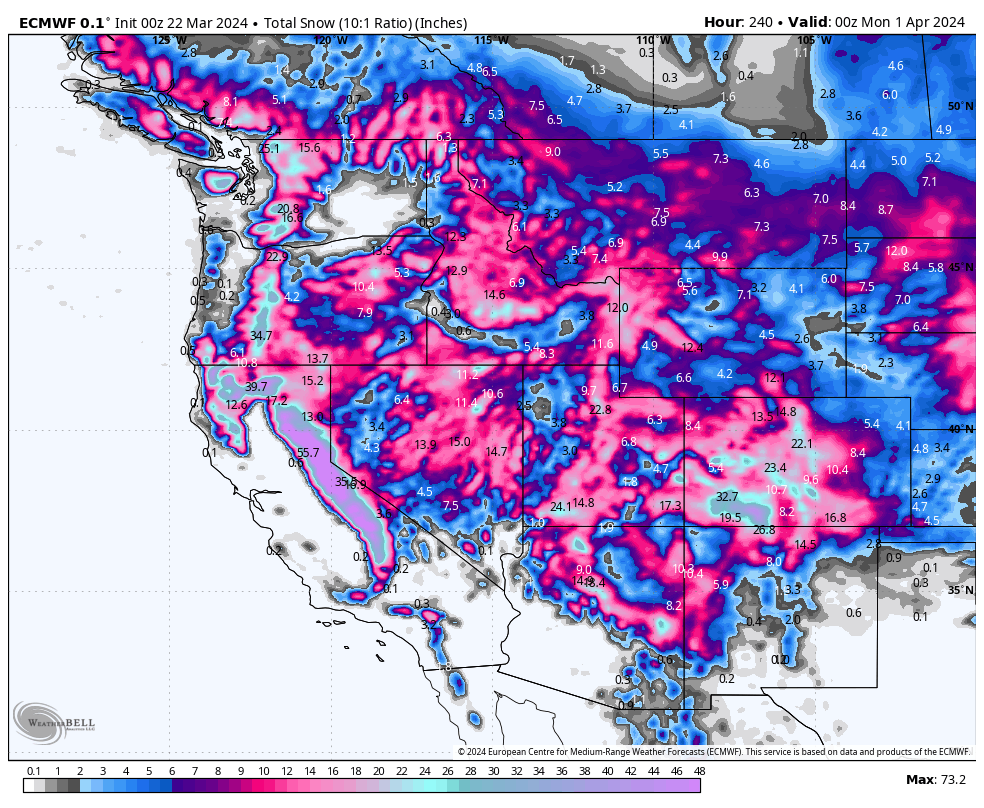
The next 10 days are looking extremely active in the West. Check out the next 10 days from the ECMWF 6 hour precipitation (Snow/Rain) painting multiple storms rolling through the west with significant lingering snowfall for the west on the tail end of each. The map is from today through April 1st.

Long story short, you really can't go wrong chasing next week. Below is the 10 day forecast from the ECMWF and GFS showing big totals all over the west, especially favoring the Sierra, Tetons, Wasatch, and southern Colorado. The Cascades will also see a slow ramp up of snow beginning this Saturday (Southern Washington) with 4K snow levels) and continues at times next week (Oregon and Washington).
Rather than several 1-2 foot events aside from the Sierra this weekend, expect several refresh periods in many areas of the west. The latter part of next week might be colder and a bit deeper. We call this the freight train (Slow and steady) that will be making stops along the way (Breaks in the action).
Please join our Concierge Program if you want to chase the best and often deepest resorts (We provide 1:1 forecasting based on several factors including snow density, wind, terrain etc.). You will often end up chasing with powderchasers.

While anything outside of 10 days is fairly low-confidence, ensembles are indicating this active pattern persisting into early April.
HELP US OUT! Please donate here to Powderchasers if you have taken advantage of our free forecasts. This Is our number one source of revenue. Free swag for you on all donations from $50 and up. $100 donations grab you a custom shirt also!
Here are the newest hats from PC that you can order here

Powder Alert New England!
Over the past week several resorts have picked up 20 plus inches of snowfall (Northern areas). The next storm is due from Friday night to late Saturday night. The system is moist and will land 12-18 inches for most of central and northern New England. Overnight totals will be impressive Saturday morning for Vermont while areas to the east will see the heaviest totals lingering into mid morning. You could start in Vermont and chase this storm to Maine for some additional freshies for Sunday. Caveat: Cold temps initially with this storm turn warmer by Saturday morning increasing density (Upside down). Temps cool behind the front. Rain will be likely closer to the coast or further south towards the NH/MA border.
Below: Total snowfall for New England Friday to Sunday. Central regions might do best from NY, VT, NH, and Maine. Northern areas of NH are also favored.

Ikon passes are on sale at the lowest pre season rates and can be purchased from the link below.


