
Summary:
Cold unstable air and unorganized bands of convection are firing in the Rockies. A more organized system will approach the Cascades and Sierra on Wednesday. Double digits are possible, especially in California that trickle into the Rockies by Thursday/Friday. Additional systems continue out west into next week.
The Cottonwoods fired last Sunday with 12-19 inches and 4-8 inches for PCMR. Snow showers that have persisted for the last several days in the Rockies keep building up those late March totals (Park City has seen 19 inches in the past week)
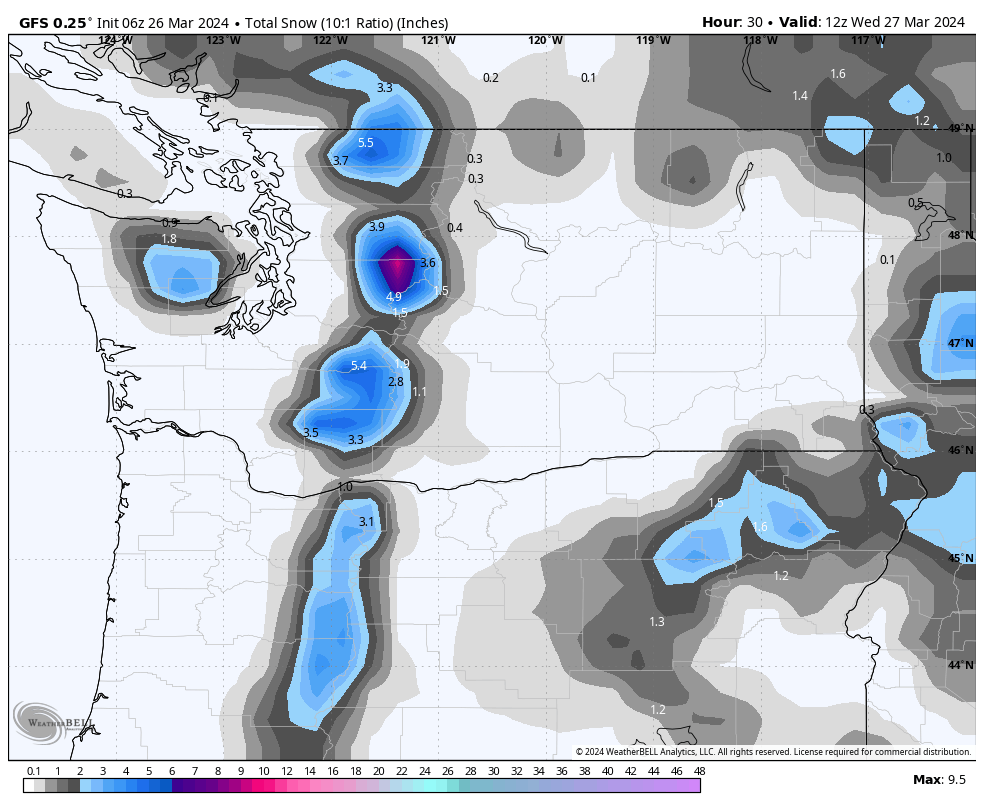
Below: Decent bands of precipitation were noted over the Ogden Valley Tuesday morning.
 .
.
Colorado scored on Monday with the highest snow totals coming from the Aspen Area Mountains and areas west towards Beaver Creek Monday morning (15 inches). Most mountains along I-70 ended up with 5-11 inches by late Monday with very good conditions reported.
Monarch reported 22 inches Monday! Taos is up to 44 inches in 72 hours! WOO HOO
The biggest news on Monday was the full burial of the Taos webcam with epic riding conditions and deep snow (12-18). An additional 6-10 inches fell Monday night (Telemetry showing 6 inches, with the cam higher totals (Seems a bit wind impacted). Regardless, it will be epic as the terrain opens on Tuesday that was closed on Monday. 44 inches in 3 days!
Below: Tao's webcam on Monday just before getting fully buried.

Snow showers are continuing on Tuesday, especially in the Tetons and Wasatch ranges. Targhee nabbed 5-6 inches of high-quality powder Monday night.
There are many options in looking for deep powder for the next 2-3 days and perhaps in the extended.
On Tuesday, the Cascades get teased with light snow, and heavier bands noted near Stevens Pass (A possible convergence zone with westerly wind direction). Timberline picked up 9 inches on Monday night! Snow will increase on Wednesday morning (Storm ski) with your highest odds of deeper turns. Wednesday offers a decent chase.
Below: Wednesday morning sees an uptick of moisture in the PNW with snow levels around 3000 rising to near 4000 by midday. Confidence is a bit higher for Baker and the higher elevations on Snoqualmie Pass or Stevens. SW wind direction on Wednesday normally pushes higher totals to the northern Cascades (Baker) but the models are somewhat optimistic in many areas.
Below: Decent timing and snowfall totals for the Sierra from Wednesday afternoon to Thursday morning. 1-1.5 inches of moisture on the western side of the lake should bring 12 plus inches of snow. The crest could approach 2 inches, however, this might be confined to areas outside the ski areas. Expect 12-15 inches of new snow for Thursday morning at many Tahoe resorts (Medium to medium dense due to winds and warmer conditions initially).

Below: Snow levels in the Sierra Wednesday afternoon start at near 5500 feet and slowly lower with this approaching colder air noted by midnight. The majority of snow will fall with the warmer air (10:1 snow ratios) with some colder higher quality towards Thursday morning as snow levels lower. This map shows the colder air just reaching Lake Tahoe in the 1-3 AM range Thursday. One issue with this storm is the strong SW winds which will be a factor as much of the precipitation falls Wednesday night. Winds remain elevated Thursday but similar to the last storm might decrease a bit for Thursday (50/50 on upper lifts). Wind-protected terrain will ski very well.

Below is the total snowfall from Tuesday to Thursday. The Cascades slowly build respectable totals. The Sierra grabs overnight powder for Thursday and the Rockies including western Idaho (Decent totals). The Rockies score Thursday to Friday.

Below: 2-day storm totals ending Saturday morning. Near double digits are possible for Wyoming, Utah, and areas of Western Colorado later this week. (Details will follow in a later post). The action starts on Thursday and drags on into Saturday with snow continuing in the extended. The Rockies generally grab 5-10 with this late-week wave. Persistent snow showers preceding this front on Thursday and showers continuing through the weekend will top the scales into double digits (Thursday to Saturday).

Below: U. of U ensembles for Alta Ski Area showing the better odds of enhanced precipitation 1st with the unstable colder NW flow Tuesday into the evening, and a second moderate wave Thursday to Friday. Both waves could deliver 6-10 inches. There is a warming trend later this week with snow densities becoming a bit higher. Persistent light to moderate snow will continue into next week.

Below: U of U ensembles for Jackson Hole showing decent odds of up to 12 inches from Thursday to Friday.

The extended looks good.
A series of storms will continue to impact the west in the extended. This barrage of moisture will keep things fresh with several periods of moderate snowfall.
Announcement: If you want to Heli ski our trusted partner Alaska Backcountry Guides has 3 seats open from 4/14 to 4/20. All bookings earn you a Powderchasers swag bag including a free concierge membership for next season!
Below: Storm #2 enters the Sierra on Friday-Saturday with another foot or more of snow. This system might favor Mammoth or the southern lake (Too far out to call). Weekly storm totals for the Sierra will be high from both systems (Thursday and Saturday totals).

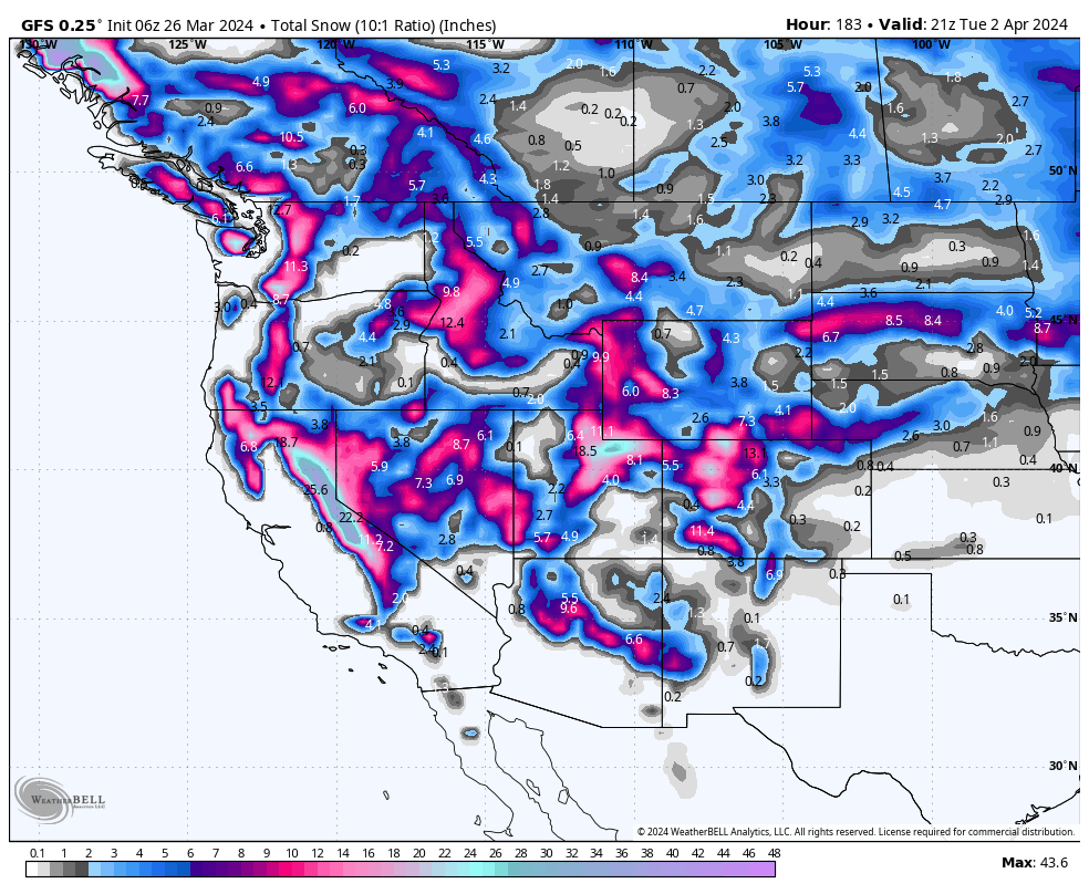
Below: 24-hour snowfall totals beginning on Saturday, March 30 (Sierra) and moving east, favoring the central or southern Rockies through next Monday, April 2nd. The latter storms seem to trend slightly further south than the initial ones we are currently seeing.

Below: Brief high pressure might ensure towards the middle of next week (April 3) with a signal of low pressure returning on both April 4/5 (Later next week) with renewed chances of another system moving ashore by April 7th. The storm door might stay open. These progressive systems appear to be taking a southerly track over California but they are too far out to put much confidence in.
We plan to chase the eclipse on April 8th so am watching carefully! Nothing this far out can predict what will happen.

HELP US OUT! Please donate here to Powderchasers if you have taken advantage of our free forecasts. This Is our number one source of revenue. Free swag for you on all donations from $50 and up. $100 donations grab you a custom shirt also!
We have new Powderchasers shirts fresh off production for sale currently for just $32 (Front and back powder)


Don't forget if you want to chase powder to the best locations every time, join our concierge package here. This provides custom 1:1 consults. You won't miss the deep.
Enjoy the powder, everyone!
Powderchaser Steve - 7AM.


