There's currently major snow falling in the Intermountain West, particularly in Colorado. Resorts already picked up a fair amount of snow during the day on Sunday, below are a few estimated totals from the day on Sunday (from telemetry and snow stakes after 8am through 8pm):
- Wolf Creek: 10"
- Snowmass: 5"
- Crested Butte: 2"
- Steamboat: 2"
Let's take a look at current radar in the region:

This precip is streaming in from the northwest on the western side of the Continental Divide and from the northeast on the eastern side. This is leading to nice upslope flow on both sides of the mountains - perfect recipe for snow. Let's take a look at short term model output for tonight by 6am Monday:

Notice the deep totals on the east and west sides of the divide due to the converging upslope winds. The HRRR is throwing bullseyes in the central mountains near Aspen and along the Front Range. Due to the northwest nature of the lower-atmospheric flow on the western slope of the mountains, Snowmass could do very well overnight and pick up solid totals by the morning.
The Canadian regional model below is showing more snowfall further south, which could allow Monarch Mountain to do well overnight:

On Monday, all models agree on the precipitation dissipating by the time lifts are open, save for strong bands in southeastern Colorado, though those bands will be over the plains and well away from any resorts.
For Colorado, the next wave rolls in on Tuesday night. This will bring a brief 24-hour push of snowfall that will benefit the central and northern mountains with an extra bit of snow. Below is the ECMWF (left) and GFS (right) outlooks for 24 hour snow by Wednesday night:

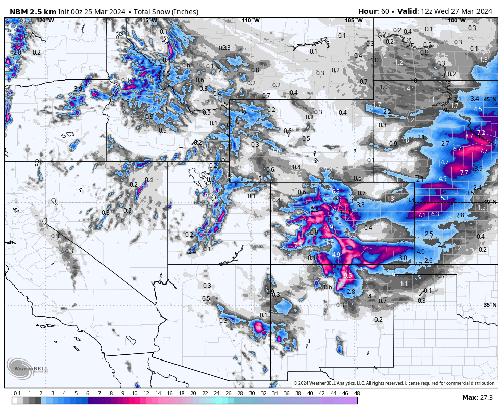
In Utah, resorts in the Cottonwood Canyons picked up ~6" during the day on Sunday. Short-range models are indicating snowfall slowing overnight, bringing maybe another inch or so. Snowfall ramps back up again on Monday morning, bringing 2-4" to Cottonwood resorts throughout the day. They should pick up another 2-5" on Monday night by Tuesday morning, with several more inches on Tuesday and Tuesday night. Totals from Sunday night through Wednesday morning should be between 8 and 15 inches for the Cottonwoods.
Below is the NBM output by Wednesday night:

The next window for snow in Utah will be on Thursday afternoon/evening as the next system rolls in. Stay tuned for updated snow total forecasts later this week.
For Wyoming, snowfall will sporadically ramp up in the afternoons and evenings and dump a few inches each day. Jackson should see 4-8" and Targhee should see 5-10". The next system moves in on Thursday morning and will last briefly, just until Thursday evening. This storm should drop around 5 inches with a few extra inches likely on the backend on Thursday night and Friday.
HELP US OUT! Please donate here to Powderchasers if you have taken advantage of our free forecasts. This is our primary source of revenue and keeps our high-quality and frequent forecasts free! Free swag for you on all donations from $50 and up. $100 donations get you a custom shirt too!
Here are the newest hats from PC that you can order here.


