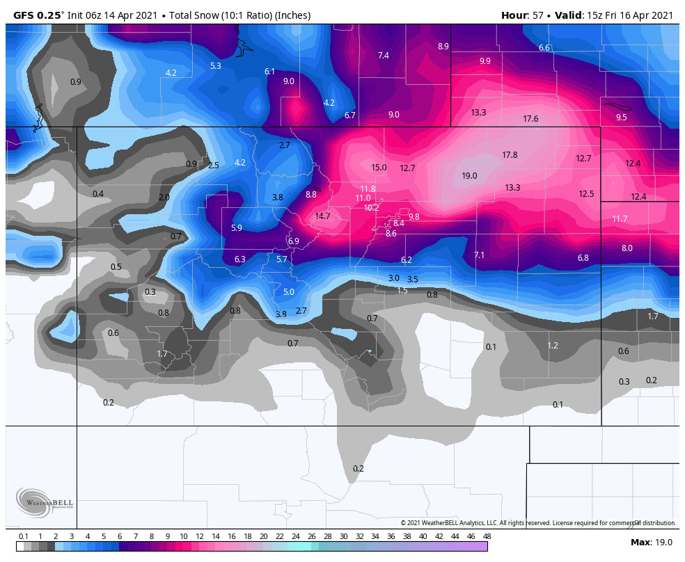
Unsettled conditions continue in the Rockies with significant snow in South central Wyoming in the short term. The latter part of the week will bring more snow for the Continental Divide closest to Denver.
Forecast:
The departing first wave of snowfall landed pretty close totals to my forecast from yesterday with many resorts in Colorado reporting 3 inches (Forecast was 2-5). Eldora, Loveland, Snowmass, Cooper all had 3 inches. In Utah similar amounts are being reported with snow continuing as forecasted through Wednesday (2-5 additional).
The upcoming storm per the various models still looks to bring another 5-10 inches to the Wasatch over the next 2 days (Light to moderate snow Wednesday, Light- moderate snow Thursday and another push of snow for Friday). Its possible that late Wednesday, early Thursday or early Friday offer some decent surprises. (Moderate freshness). Best Guess: 3-6 inches each day through Friday. Sum total will be decent with no overnight or double digit dump in a 12-24 hour period. Upper Cottonwoods will be deepest above 9,000 feet. As of 8AM Wednesday 3 inches has fallen in the Cottonwoods.
In Colorado, the final push of moisture will happen late Thursday to Friday. Snow will increase over the Continental Divide Thursday afternoon and continue into Friday. The American GFS is still bullish with double digits through Friday afternoon. The Europeans keeps the low further north and provides 4-9 inch solutions. The Canadian is also pretty bullish. Best Guess: 5-11 inches for Friday by midday along the Divide (Loveland and Eldora might report the deepest totals) followed by A-Basin, and Winter Park. Berthoud Pass should also do well with this pattern. The mountains further west along I-70 will see lower amounts (3-6). Higher amounts are possible as the models are still not in synch with this decent April system.
Snow will continue albeit lighter Friday night into Saturday especially along the Continental Divide (Additional 2-5) Its possible you can score moderate powder both Friday and Saturday.
Disclosure: If the GFS pans out, this will be a deeper storm than what is being forecasted. I would not be surprised to see some upside totals especially by midday Friday.
In Wyoming significant snow will fall in the southeast sections of the Wind River Range (12-18) Also, if you live in Jackson you might score some pow south towards the mountains near Pinedale.
This forecast will be updated tomorrow.
Powderchaser Steve


