Powderchasers has issued a powder watch for a colder pattern to set up over the west for the weekend.
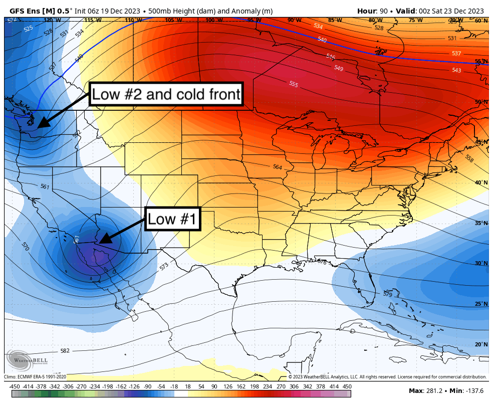
2 Low pressure systems will possibly merge over the 4 corners at some point by late Saturday. The Sierra continues to get pounded with rain and wind below 8,000 feet and some deeper snow totals likely at the summits. Colder temps and some moderate snow move into the PNW for the end of the week with some higher totals possible in the Rockies by Saturday/Sunday. There are still model differences on the track of these storms.
Wind gusts Monday night in the Sierra were in excess of 100 MPH at 8700 feet. (112 MPH noted on the Palisades Telemetry). Mammoth snow telemetry was showing near 4 inches of snow near the base area. Most resorts around Lake Tahoe were reporting 3-7 inches likely above 8,000 feet Tuesday morning. The summits in the Sierra are likely deeper.
SIERRA
Snow and rain will continue in 2 more waves peaking Tuesday PM to Wednesday AM and the final wave Wednesday night to Thursday. These waves will continue to push moderate snow to the summits above 8,000 feet. Some locations, especially Kirkwood summit or areas south to Mammoth might see higher amounts (Storm totals at upper elevations will likely be 8-17 inches with 0-4 at the bases. Some peaks could exceed these totals. Snow density will be creamy so definitely bring the surf wide boards and your waterproof outer layers for the lower elevations (Mammoth might see mainly snow at the bases). We might end up with feast and famine with 0-4 inches at the base and 10-18 inches at some peaks by Thursday morning.
ROCKIES and PNW
Below: 2 Low pressure systems for late this week. One moves from the PNW to the Rockies while the stubborn CA low finally moves east.

For the Rockies and PNW some good news is on the horizon for a modest storm due late this week. Colder temps will filter into the PNW Friday bringing moderate snow to the Cascade ranges midday Friday to Saturday. This system is a quick mover and will likely land 3-8 inches of decent density powder favoring areas in Washington and western BC (Whistler) with a bit less into Oregon. All areas of the PNW will see some snowfall from this system (Friday/Saturday). Ride last chair Friday or 1st chair Saturday with cooler temps.
That cold front races over Idaho, Montana, Wyoming, Utah and Colorado by Saturday (December 23). 2 low pressure systems may merge over Colorado this weekend.
Below: Fast moving cold front seen late this week in the PNW extending into the Rockies for the weekend (Map is late Friday to Sunday timeframe).

Models are not in good agreement on the track of this storm. We have high confidence for the Wasatch Range and areas of Colorado with the Tetons a solid wildcard. The American model keeps the northern low over northern Utah and most of Wyoming (Tetons) eventually tracking over the core of the central and northern mountains of Colorado (Summit County). This solution also shows heavy snowfall for the NE plains of Colorado (NE border). But wait, lets look at another solution.
The European solution shows a southward progression with less snow in the Tetons tracking from northern Utah to southern Colorado (San Juan Range). This solution shows higher snow totals for southern Colorado while the 2 lows merge together.
Below: American GFS showing a storm track this weekend impacting the PNW (Late week) into Montana and Wyoming (Tetons are highlighted) with decent totals possible for the northern and central Wasatch in Utah. This would eventually track over northern Colorado (I-70 corridor) and head east towards the Nebraska border (NE corner). Western Idaho will score moderate snowfall with either scenario below.

Below: The European model pushes a bit further south over the PNW extending into A wider area of Utah, Arizona, and New Mexico. If both lows merge over the 4 corners (Colder air and wet warm moist air from the Sierra) we could get some decent totals in the San Juan Range. This solution would result in less snow for the Tetons or Montana. We are leaning slightly towards this solution.

Meanwhile Alaska continues to get crushed with 2-4 feet expected for the ranges near Valdez (Thompson Pass) and 10-18 inches for Alyeska through Sunday (Slight warming trend this weekend).
Our long time partner Alaska Backcountry Guides still has some Heli openings for its epic terrain, fantastic staff, and deep powder (They are getting hammered). We have sent many guests there. Powderchasers will provide a free concierge package for the 23-24 or 25 season for all bookings with ABG. Mention PC for this free package.
Below: Open Heli seats with Alaska Backcountry Guides.

Extended Pow
The extended forecast looks to stay unsettled just after the holiday extending into the 1st week of January with several pulses of light or moderate moisture noted for the PNW and Sierra Ranges. We are not confident if much or any of this moisture will push east into the Rockies as of yet.
Announcements
This post is sponsored by Skis.com and Snowboards.com. Powderchasers supports them being family-owned and with a vast selection of quality gear and clothing. Please check them out as supporters of this forecast and truly a fantastic product mix. We will donate a PC tee shirt for every purchase over $200 (Email us).If you want to chase powder with Powderchasers sign up for the concierge package for the deepest resorts to chase to and 1:1 custom forecasting with our staff. Also, if you have read this far, please donate for the holidays to continue receiving these free forecasts. We appreciate the community support.
Powderchaser Steve - @powderchasersteve - Instagram,


