SUMMARY: The west is going to reap the coldest temps of the season, near 0 degrees F in some spots by the weekend. Midweek systems impact northern Wyoming and southern Montana while the grand finale slams into the west with frigid temps and deep snow by the weekend.
FORECAST:
light snow is falling in many areas of northern Wyoming near the Montana border. The weekend storm brought some snow to Red Lodge Mountain that sits near the MT/WY border.
Below: Red Lodge Mountain Ski area - Montana (Webcam this morning)

Here is a photo of the sunrise on Saturday morning from Jackson Wyoming- Photo: @powderchasersteve via Instagram. It was a brief period of epic alpenglow over the Tetons.

In the short term forecast light snow will continue for much of central Montana extending into some spots of northern Wyoming through Monday night. The models bring another moderate system from the interior of BC (Moderate snowfall) through Montana and north/central Wyoming late Wednesday into Thursday. This system will favor Glacier National Park, Teton Pass Ski Area, Showdown, and Red Lodge Mountain. Amounts will likely exceed 6 inches. This cold front will also extend some light snow to the Tetons (Wildcard), Big Sky and Bridger Bowl but amounts will be minimal. A brief warm up may happen over the Rockies late week before frigid temps slam the west late this weekend.
Another and much more potent and colder system will impact the west in the extended forecast, so keep reading.
EXTENDED:
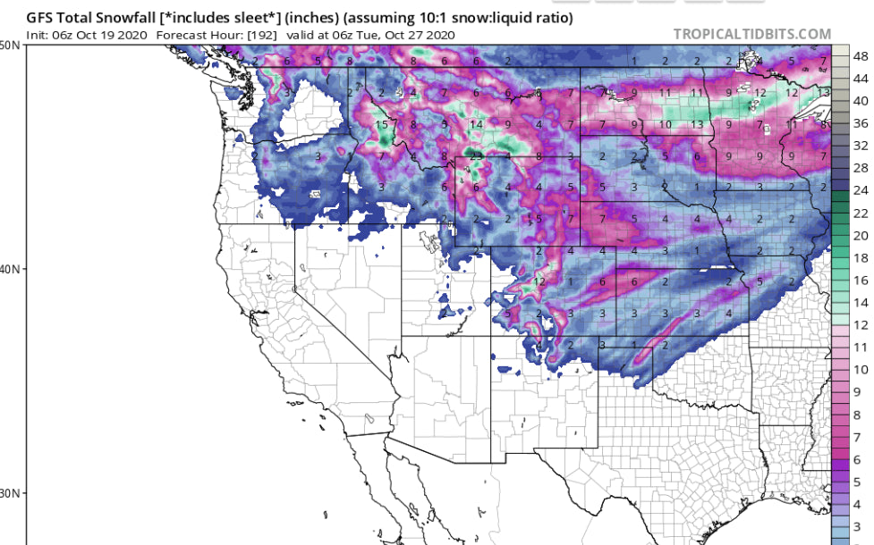
One thing for certain for the weekend. Arctic air more typical of January will slam into the west. Temps at 10K will be well below 0F. In fact, spots in Wyoming and Montana will see 0 degree Valley Temps by Sunday. Significant snow is likely for many areas of the west. The Euro shows an excess of a foot for many of the Pacific Northwest Resorts (Western Cascade Range) Friday-Saturday. The GFS is less optimistic showing light to moderate snow for the Cascades. The Euro and GFS are more in synch for the Rockies showing decent snowfall totals for much of the intermountain west this weekend. The highest confidence will be for interior Montana, Wind River Range of Wyoming, extending into most of Colorado by Sunday/Monday. The American GFS model keeps higher amounts just east of the Tetons while the European model pushes the system further west (Heavier snow for the Tetons). In looking at wind directions, confidence is very high for interior Wyoming, interior Montana, and much of Colorado. Bottom Line: Most of the ski resorts from the Pacific Northwest and Rockies will see snowfall late this weekend with even the San Juan Range and New Mexico in the action Sunday-Monday. Some areas will be reporting 12 plus by late next weekend. The wildfires in Colorado will gain some much needed moisture by Sunday. We are still 6-8 days out so confidence is only moderate on exactly how things pan out.
Below: Very unseasonable temps at 10K by late this weekend. -20C in some spots of the northern Rockies.

Below: The most optimistic European Model showing significant snowfall for the Cascades, north central Idaho, much of Montana, Wyoming and Colorado late this weekend. The American GFS is less optimistic especially for western Wyoming, Montana and the Cascades (Lighter amounts).

ANNOUNCEMENT: We have partnered with Tire Rack for winter tires and wheel packages. Based on what we are seeing for even lower elevations, we suggest you consider putting your winter tires on early. Check out these winter packages for some great options.
Please consider joining the Powder Concierge for specific forecasting for your trip planning, resort pics, reservations, and the best opportunity to stab deep pow.
Powderchaser Steve


